Santander, February 19th-22nd 2008 - Aranzadi
Santander, February 19th-22nd 2008 - Aranzadi
Santander, February 19th-22nd 2008 - Aranzadi

Create successful ePaper yourself
Turn your PDF publications into a flip-book with our unique Google optimized e-Paper software.
Of Shell and Sand: Coastal Habitat Availability and Human Foraging Strategies at Punta Candelero (Humacao, Puerto Rico)<br />
275<br />
using heavy machinery after Miguel Rodríguez’s<br />
archaeological intervention in the late 1980s and<br />
early 1990s, and was then covered with a thick layer<br />
of rubble fill (up to a metre thick in some areas).<br />
Recent development has widely impacted the<br />
region, and the original topography has been severely<br />
modified. The shoreline is classified as of moderate<br />
to high erosion risk, based on wave intensity.<br />
The littoral presents a wide and rich mosaic of<br />
habitats very close to the shore. Modern benthic<br />
habitats, as classified by the National Oceanic and<br />
Atmospheric Administration’s Biogeography Team<br />
(NOAA 2001), include various types of consolidated<br />
substrates such as bedrock, corals and other<br />
reefs, as well as sandy shores, sea grass habitats<br />
and patches of macroalgae (Figure 4).<br />
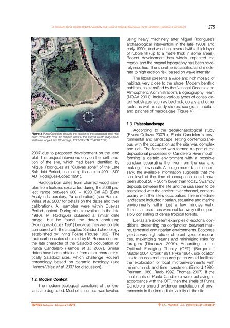
Figure 3. Punta Candelero showing the location of the suggested 'shell middens'.<br />
White dots mark the sampled units for this study (Satellite image modified<br />
from Google Earth 2004 image, 18°05’33.50”N 65°47’26.76”W).<br />
2007 due to proposed development on the land<br />
plot. This project intervened only on the north section<br />
of the site, which had been identified by<br />
Miguel Rodríguez as “Cuevas zone” of the Late<br />
Saladoid Period, estimating its date to 400 – 800<br />
AD (Rodríguez-López 1991).<br />
Radiocarbon dates from charred wood samples<br />
from features excavated during the 2006 project<br />
range between 660 – 1020 Cal AD (Beta<br />
Analytic Laboratory, 2σ calibration) (see Ramos-<br />
Vélez et al. 2007 for details on the dates and their<br />
calibration). All samples were within Cuevas<br />
Period context. During his excavations in the late<br />
1980s, M. Rodríguez obtained a similar date<br />
range, but he found the dates confusing<br />
(Rodríguez-López 1991) because they are too late<br />
compared with the accepted Saladoid chronology<br />
established by Irving Rouse (Rouse 1992). The<br />
radiocarbon dates obtained by M. Ramos confirm<br />
the late character of the Saladoid occupation on<br />
Punta Candelero (Ramos et al. 2007). Similar<br />
dates have been obtained from other characteristically<br />
Saladoid sites, which challenge Rouse’s<br />
chronology based on ceramic typology (see<br />
Ramos-Vélez et al. 2007 for discussion).<br />
1.2. Modern Context<br />
The modern ecological conditions of the foreland<br />
are degraded. Most of its surface was levelled<br />
1.3. Palaeolandscape<br />
According to the geoarchaeological study<br />
(Rivera-Collazo 2007b), Punta Candelero’s environmental<br />
and landscape setting contemporaneous<br />
with the occupation at the site was complex<br />
and rich. The foreland was formed as part of the<br />
depositional processes of Candelero River mouth,<br />
forming a deltaic environment with a possible<br />
sandbar separating the river from the sea and<br />
making it flow south. Although more data is necessary,<br />
the available information suggests that the<br />
sea level at the time of occupation could have<br />
been about 20 – 30cm lower than today. Swampy<br />
deposits between the site and the sea seem to be<br />
associated with the ancient river channel, contemporary<br />
with the site’s occupation. The immediate<br />
landscape included riparian, estuarine and marine<br />
environments within just a few minutes walk.<br />
Terrestrial resources were not far away either, possibly<br />
consisting of dense tropical forests.<br />
Deltas are excellent examples of ecotonal conditions,<br />
presenting the conjunction between marine,<br />
terrestrial and riparian environments. Ecotones<br />
yield a very high ratio of different types of resources,<br />
maximizing returns and minimizing risks for<br />
foragers (Dincauze 2000). According to the<br />
Optimal Foraging Theory (OFT) (Borgerhoff<br />
Mulder 2004, Cronk 1991, Pyke 1984), site location<br />
inside an ecotonal resource patch would facilitate<br />
the exploitation of local microenvironments with<br />
minimum risk and time investment (Binford 1980,<br />
Perlman 1980, Raab 1992, Thomas 2007). If the<br />
inhabitants of Punta Candelero were behaving in<br />
accordance with the OFT, then the shells of Punta<br />
Candelero should evidence exploitation of environments<br />
in the immediate vicinity of the site.<br />
MUNIBE Suplemento - Gehigarria 31, 2010<br />
S.C. <strong>Aranzadi</strong>. Z.E. Donostia/San Sebastián