Basis of Design Book 2 - City of St. Petersburg
Basis of Design Book 2 - City of St. Petersburg
Basis of Design Book 2 - City of St. Petersburg
You also want an ePaper? Increase the reach of your titles
YUMPU automatically turns print PDFs into web optimized ePapers that Google loves.
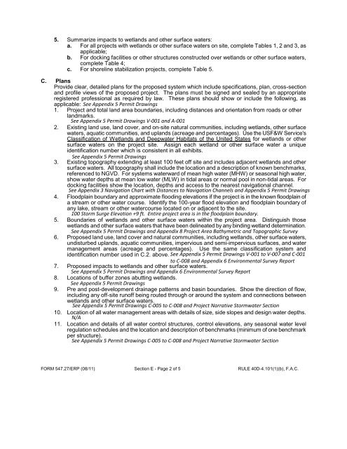
5. Summarize impacts to wetlands and other surface waters:<br />
a. For all projects with wetlands or other surface waters on site, complete Tables 1, 2 and 3, as<br />
applicable;<br />
b. For docking facilities or other structures constructed over wetlands or other surface waters,<br />
complete Table 4;<br />
c. For shoreline stabilization projects, complete Table 5.<br />
C. Plans<br />
Provide clear, detailed plans for the proposed system which include specifications, plan, cross-section<br />
and pr<strong>of</strong>ile views <strong>of</strong> the proposed project. The plans must be signed and sealed by an appropriate<br />
registered pr<strong>of</strong>essional as required by law. These plans should show or include the following, as<br />
applicable:<br />
1. Project and total land area boundaries, including distances and orientation from roads or other<br />
landmarks.<br />
2. Existing land use, land cover, and on-site natural communities, including wetlands, other surface<br />
waters, aquatic communities, and uplands (acreage and percentages). Use the USF&W Service's<br />
Classification <strong>of</strong> Wetlands and Deepwater Habitats <strong>of</strong> the United <strong>St</strong>ates for wetlands or other<br />
surface waters on the project site. Assign each wetland or other surface water a unique<br />
identification number which is consistent in all exhibits.<br />
3. Existing topography extending at least 100 feet <strong>of</strong>f site and includes adjacent wetlands and other<br />
surface waters. All topography shall include the location and a description <strong>of</strong> known benchmarks,<br />
referenced to NGVD. For systems waterward <strong>of</strong> mean high water (MHW) or seasonal high water,<br />
show water depths at mean low water (MLW) in tidal areas or normal pool in non-tidal areas. For<br />
docking facilities show the location, depths and access to the nearest navigational channel.<br />
4. Floodplain boundary and approximate flooding elevations if the project is in the known floodplain <strong>of</strong><br />
a stream or other water course. Identify the 100-year flood elevation and floodplain boundary <strong>of</strong><br />
any lake, stream or other watercourse located on or adjacent to the site.<br />
5. Boundaries <strong>of</strong> wetlands and other surface waters within the project area. Distinguish those<br />
wetlands and other surface waters that have been delineated by any binding wetland determination.<br />
6. Proposed land use, land cover and natural communities, including wetlands, other surface waters,<br />
undisturbed uplands, aquatic communities, impervious and semi-impervious surfaces, and water<br />
management areas (acreage and percentages). Use the same classification system and<br />
identification number used in C.2. above.<br />
7. Proposed impacts to wetlands and other surface waters.<br />
8. Locations <strong>of</strong> buffer zones abutting wetlands.<br />
9. Pre and post-development drainage patterns and basin boundaries. Show the direction <strong>of</strong> flow,<br />
including any <strong>of</strong>f-site run<strong>of</strong>f being routed through or around the system and connections between<br />
wetlands and other surface waters.<br />
10. Location <strong>of</strong> all water management areas with details <strong>of</strong> size, side slopes and design water depths.<br />
11. Location and details <strong>of</strong> all water control structures, control elevations, any seasonal water level<br />
regulation schedules and the location and description <strong>of</strong> benchmarks (minimum <strong>of</strong> one benchmark<br />
per structure).<br />
FORM 547.27/ERP (08/11) Section E - Page 2 <strong>of</strong> 5 RULE 40D-4.101(1)(b), F.A.C.


