District II Quebec City-Les Escoumins - Transports Canada
District II Quebec City-Les Escoumins - Transports Canada
District II Quebec City-Les Escoumins - Transports Canada

You also want an ePaper? Increase the reach of your titles
YUMPU automatically turns print PDFs into web optimized ePapers that Google loves.
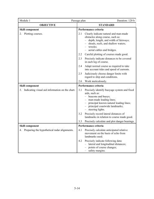
Module 1 Passage plan Duration: 120 h<br />
Skill component<br />
2. Plotting courses.<br />
OBJECTIVE<br />
Skill component<br />
3. Indicating visual aid information on the chart.<br />
Skill component<br />
4. Preparing the hypothetical radar alignments.<br />
STANDARD<br />
Performance criteria<br />
2.1 Clearly indicate natural and man-made<br />
obstacles along course, such as:<br />
– depth, length, and width of fairways;<br />
– shoals, reefs, and shallow waters;<br />
– wrecks;<br />
– aerial cables and bridges.<br />
2.2 Careful plotting of courses made good.<br />
2.3 Precisely indicate distances to be covered<br />
in each leg of course.<br />
2.4 Adapt normal course as required to take<br />
into account tides and speed of currents.<br />
2.5 Judiciously choose danger limits with<br />
regard to ship and conditions.<br />
2.6 Work meticulously.<br />
Performance criteria<br />
3.1 Precisely identify buoyage system and fixed<br />
aids, such as:<br />
– beacons and buoys;<br />
– man-made leading lines;<br />
– principal known natural leading lines;<br />
– principal coastwide landmarks;<br />
– steering lights.<br />
3.2 Precisely record lateral distances of<br />
landmarks in relation to course made good.<br />
3.3 Precisely calculate and plot danger bearings.<br />
Performance criteria<br />
4.1 Precisely calculate anticipated relative<br />
movement on the basis of echo from<br />
landmarks used.<br />
4.2 Precisely indicate following data:<br />
– lateral and longitudinal distances;<br />
– points of course changes;<br />
– safety margins.<br />
5-14