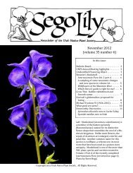
December 2012 Number 1 - Utah Native Plant Society
December 2012 Number 1 - Utah Native Plant Society
December 2012 Number 1 - Utah Native Plant Society

You also want an ePaper? Increase the reach of your titles
YUMPU automatically turns print PDFs into web optimized ePapers that Google loves.
Calochortiana <strong>December</strong> <strong>2012</strong> <strong>Number</strong> 1<br />
COLORADO: DELTA CO.: Dominguez Creek, W of<br />
the Gunnison River below Bridgeport, 0-1.5 mi up<br />
Dominguez Canyon, 19 May 1982, Atwood & Thompson<br />
8773 (NY); MESA CO.: NW end of Sinbad Valley<br />
at head of Salt Creek Canyon, 26 May 1983, Atwood<br />
9262 (CAS, NY); 2 mi E of Bedrock, Paradox Valley,<br />
23 May 1984, Atwood et al. 9728 (NY); 6 mi SSW of<br />
Grand Junction, Rough Canyon, base of sandstone wall,<br />
18 May 1988, Dorn 4886 (NY, RM); open slope 10 mi<br />
S of Gateway, 11 June 1949, Harrington 4423 (RM);<br />
Grand Junction, Colorado Monument Park, 03 June<br />
1921, Osterhout 6142 (RM, RSA); Colorado N.M., west<br />
entrance, white hills, 17 May 1982, Siplivinsky 3273<br />
(RM); Colorado N.M., head of Ute Canyon, within park<br />
boundary, 25 May 1982, Siplivinsky 3379 (RM); near<br />
hq. Colorado N.M., 6 mi S of Fruita, mesa summit, 21<br />
May 1948, Weber 3840 (CAS, DUD, RM, US); MON-<br />
TROSE CO.: La Sal Creek, 4 mi S of Paradox, near cliff<br />
dwellers mine, 20 May 1982, Atwood & Thompson<br />
8798 (NY, RM); Monogram Mesa, 6 mi W of Vancorum,<br />
3 June 1961, Barneby 13046 (CAS, NY, RSA);<br />
Paradox Valley, N slope, 25 April 1986, Franklin 2838<br />
(NY, RM); ca 18 air mi NW of Naturita, ca 2.5 air mi S<br />
of Bedrock, E side Dolores River Canyon, E facing<br />
slope on W side canyon, 17 June 1995, Moore 5502<br />
(RM); Slick Rock Canyon, Dolores River, ca 18 air mi<br />
W of Naturita, at mouth and surrounding area of Leach<br />
Creek, SW facing wash, 05 July 1995, Moore 6334<br />
(RM); Slick Rock Canyon, Dolores River, ca 18 air mi<br />
W of Naturita, at mouth and surrounding area of Leach<br />
Creek, SW facing wash, 05 July 1995, Moore 6335<br />
(RM); near Naturita, SW Colorado, dry hills, 22 May<br />
1914, Payson 335 (RM); SAN MIGUEL CO.: Colorado<br />
side of Island Mesa, 27 May 1998, Atwood & Trotter<br />
23617 (NY); roadside, rocky cedar breaks,1 mi S of<br />
Gladel, 09 June 1951, Penland & Hartwell 4178 (RM);<br />
W end Gypsum Valley, rocky mouth of Hamm Canyon,<br />
09 June 1949, Weber 4735 (CAS, DUD, RM, RSA, UC,<br />
US); UTAH: CARBON CO.: ca 1.5 mi N of Emery Co.<br />
line along US Hwy 50-6, 29 April 1965, Welsh 3875<br />
(NY); EMERY CO.: San Rafael Swell, Chimney Rock<br />
flats, 17 May 1979, Harris 116 (RM); near junction of<br />
Lower Black Box Rd to Swazys Leap and Sulphur<br />
Spring, 19 May 1992, Heil & Hyder 7132 (RSA); San<br />
Rafael Swell, near Temple Mtn, 30 April 1968, Higgins<br />
& Reveal 1277 (NY, RM); San Rafael Swell, 18 May<br />
1915, Jones s.n. (UC), 12 May 1914, Jones s.n. (POM);<br />
Red Plateau, SW of Woodside, along rd to Castledale,<br />
6.9 mi W of US 50, 5 June 1958, Raven 13079 (CAS,<br />
GH, NY); Red Plateau, SE of Woodside, 13 June 1947,<br />
Ripley & Barneby 8675 (RSA); rocky draw, San Rafael<br />
Swell, 22 mi W of Green River on I-70, 1mi E of rest<br />
area just below Rattlesnake Bench, 28 April 1979,<br />
Shultz et al. 3113 (NY, RM, RSA); Summerville<br />
[Wash], at Woodside, 27 April 1977, Welsh & Taylor<br />
14624 (NY); GARFIELD CO.: upper E end of Choprock<br />
Bench, ca 30 mi ESE of Escalante, 6 May 1987,<br />
Tuhy & Holland 3127 (NY, RSA); head of North Wash,<br />
28 April 1981, Welsh 20368 (NY, RSA); GRAND CO.:<br />
Kane Springs Rd, 13 mi S of Moab, [no date], Atwood<br />
7478 (NY); Sandflat Rd, E of Moab 12 mi., ca 0.25 mi<br />
W of Forest Service boundary, 20 May 1982, Atwood &<br />
Thompson 8787 (NY,RM); Arches N.M., 5 mi NW of<br />
Moab, 21 May 1984, Atwood et al. 9695 (NY); 11 mi N<br />
of Moab, 18 May 1955, Barneby 12753 (CAS, NY,<br />
RSA); 1 mi N of Moab, 14 April 1940, Beath 48 (RM);<br />
Arches road, 04 May 1947, Beath s.n. (RM); near<br />
Moab, 17 May 1940, Beath & Goodding 6-373 (RM); 8<br />
mi NW of Moab, along UT Hwy 160, 28 April 1961,<br />
Bright 135 (NY); between Moab and bridge, 13 May<br />
1933, Cottam 5623 (RM); hillside in the Colorado River<br />
Canyon, a little below Salt Wash, NE of Moab, 9 May<br />
1961, Cronquist 8974 (GH, NY, RSA); slope E above<br />
Hwy 128, 0.15 mi N of Pole Canyon, 05 May 1985,<br />
Franklin 1391 (NY, RM); Red Hills SE above White<br />
Ranch along Colorado River, 07 May 1985, Franklin<br />
1421 (NY, RM); 3.7 mi due E of Moab, sand flats<br />
among sandstone fins, 17 April 1986, Franklin 2679<br />
(RM); Mat Martin Point, sand pockets on slickrock, 12<br />
May 1986, Franklin 2933 (RM); Sevenmile Mesa, point<br />
W of confluence of Dolores River and Fisher Cr., ca 25<br />
mi due NE of Moab, 18 May 1986, Franklin 3104<br />
(RM); Onion Creek, 22 May 1984, Goodrich et al.<br />
20398 (NY); N end of La Sal Mountains, Fisher Valley,<br />
22 May 1984, Goodrich et al. 20414 (NY); 1 mi NE of<br />
Moab, 0.5 mi along UT Hwy 128, along Colorado<br />
River, 30 April 1961, Hanson 148 (NY); on edge of<br />
Colorado River, Moab, clay buttes, 09 May 1933, Harrison<br />
5945 (RM); cliffs above headquarters, S edge of<br />
Arches N.M., sandy terraces among rocks, 25 April<br />
1947, Harrison 11123 (RSA, US), Harrison s.n. (UC);<br />
south of Courthouse Towers, Arches N.M., sandy flat,<br />
17 May 1950, Harrison 11383 (US, UC); The 'Neck" 13<br />
miles due WSW of Moab, sand rock ridge, 11 June<br />
1941, Harrison et al. 10286 (US); Arches N.M., 29 June<br />
1948, Howell 24752 (CAS,RSA); near Skyline Arch,<br />
Arches N.M., 7 September 1968, Howell & True 44906<br />
(CAS,NY); 10 mi N of Moab, sandy plain, 17 June<br />
1955, Isely 6460 (RSA, US); Castle Valley, May 1931,<br />
Jones s.n. (POM); red sandstone banks just north of<br />
Kane Springs, ca. 15 miles south of Moab, 21 April<br />
1966, Ledingham 4694 (UC); 5 mi N of Moab, 08 June<br />
1939, Porter 1796 (RM), Porter 1797 (RM); San Sige<br />
[illegible] Hollow, Grand River Canon [Grand River<br />
Canyon near Moab, June 1899], 1899, Purpus s.n. (UC);<br />
sandy slopes near headquarters, Arches N.M., near<br />
Moab, 6 June 1962, Rever & Belcher 73 (NY); W of<br />
Thompson, 13 June 1947, Ripley & Barneby 8662<br />
(RSA); Spanish Valley, 4.5 mi E of Moab, along roadside<br />
in town, 03 May 2000, Spencer 1487 (NY, RM);<br />
153