December 2012 Number 1 - Utah Native Plant Society
December 2012 Number 1 - Utah Native Plant Society
December 2012 Number 1 - Utah Native Plant Society

Create successful ePaper yourself
Turn your PDF publications into a flip-book with our unique Google optimized e-Paper software.
Calochortiana <strong>December</strong> <strong>2012</strong> <strong>Number</strong> 1<br />
New Mexico are the least studied and documented in<br />
published literature. The following are a few examples<br />
of some historic and extant New Mexico ciénegas that I<br />
have personally studied.<br />
San Simon Ciénega was one of the wetland jewels in<br />
the crown of the southwest. It was a wet valley bottom<br />
about five miles long and a half mile broad that straddled<br />
the New Mexico/Arizona border in the upper-most<br />
reach of the San Simon Valley of Hidalgo County. The<br />
perennial spring-run creek had emergent marsh vegetation<br />
surrounded by wet meadow bordered with riparian<br />
woodland in sharp contrast to the adjacent Chihuahuan<br />
Desert scrub. When I first visited in 1994, San Simon<br />
Ciénega was dead and being covered with mesquite<br />
(Prosopis glandulosa Torrey). Many decadent cottonwood<br />
and willows trees still survived as reminders of<br />
the former wetland. The situation is the same today, but<br />
a little grimmer as these senescent tree remnants continue<br />
to decline.<br />
The lower part of San Simon Ciénega in Arizona was<br />
destroyed just before the turn of the twentieth century<br />
by regional overgrazing of cattle and an arroyo erosion<br />
cut that lowered the water table (Hendrickson and<br />
Minckley 1985). The arroyo headcut was arrested by a<br />
dam at the New Mexico border and seemed to spare the<br />
New Mexican part of the ciénega. Then irrigated cotton<br />
farming moved into the Arizona side of the valley and<br />
intercepted the spring aquifer emanating from the Chiricahua<br />
Mountains. An anonymous and undated report at<br />
the New Mexico Energy, Minerals and Natural Res-<br />
ources Department, Forestry Division documents most<br />
of the following events. The spring-run creek stopped<br />
flowing in 1952, shortly after irrigated agriculture<br />
started. When the Mexican duck was listed as an Endangered<br />
species, the New Mexico Game and Fish Department<br />
and federal Bureau of Land Management attempted<br />
to create some open-water nesting habitat in the<br />
still wet valley bottom by detonating powerful explosives.<br />
The resulting crater pools were not suitable nesting<br />
habitat, created habitat for weedy plants, and the<br />
valley bottom continued to dry from irrigated farming in<br />
the adjacent uplands. A nesting pond was excavated and<br />
frequently pumped full of water, but was eventually<br />
abandoned after the Mexican duck was removed from<br />
the list of Endangered species for taxonomic reasons.<br />
All permanent wetlands quickly disappeared from the<br />
valley.<br />
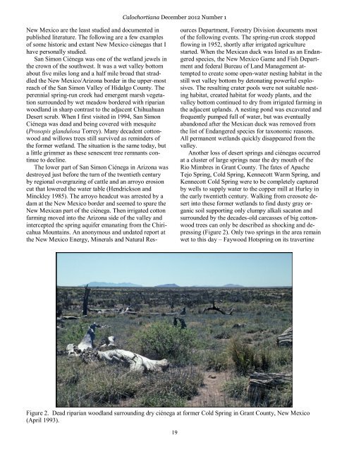
Another loss of desert springs and ciénegas occurred<br />
at a cluster of large springs near the dry mouth of the<br />
Rio Mimbres in Grant County. The fates of Apache<br />
Tejo Spring, Cold Spring, Kennecott Warm Spring, and<br />
Kennecott Cold Spring were to be completely captured<br />
by wells to supply water to the copper mill at Hurley in<br />
the early twentieth century. Walking from creosote desert<br />
into these former wetlands to find dusty gray organic<br />
soil supporting only clumpy alkali sacaton and<br />
surrounded by the decades-old carcasses of big cottonwood<br />
trees can only be described as shocking and depressing<br />
(Figure 2). Only two springs in the area remain<br />
wet to this day – Faywood Hotspring on its travertine<br />
Figure 2. Dead riparian woodland surrounding dry ciénega at former Cold Spring in Grant County, New Mexico<br />
(April 1993).<br />
19