December 2012 Number 1 - Utah Native Plant Society
December 2012 Number 1 - Utah Native Plant Society
December 2012 Number 1 - Utah Native Plant Society

Create successful ePaper yourself
Turn your PDF publications into a flip-book with our unique Google optimized e-Paper software.
Calochortiana <strong>December</strong> <strong>2012</strong> <strong>Number</strong> 1<br />
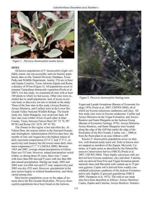
Figure 1. Physaria thamnophila rosette leaves.<br />
SITES<br />
All known populations of P. thamnophila (eight verifiably<br />
extant, one not accessible, and one historic population;<br />
data on file, Natural Diversity Database, Texas<br />
Parks and Wildlife Department, Austin, TX) are in Starr<br />
and Zapata Counties, Texas, between Zapata and Roma,<br />
a distance of 69 km (Figure 3). All populations occur in<br />
remnant Tamaulipan thornscrub vegetation (Poole et al.<br />
2007). For this study, we examined all sites with at least<br />
100 plants to which we had access. Other sites were excluded<br />
due to small populations, lack of access to private<br />
land, or discovery too late to include in the study.<br />
Three of the four sites in this study (Arroyo Ramirez,<br />
Arroyo Morteros, and Cuellar) were in the Lower Rio<br />
Grande Valley National Wildlife Refuge. The fourth<br />
study site, Santa Margarita, was on private land. All<br />
four sites were within 18 km of each other in Starr<br />
County, Texas, between Falcon Dam (26° 33’ N, 99°<br />
09’W) and Roma (26° 24’N, 99° 01’W).<br />
The climate in this region is hot and often dry. At<br />
Falcon Dam, the nearest station in the National Oceanic<br />
and Atmospheric Administration (NOAA) data base, the<br />
months of July and August have the highest means of<br />
daily maximum temperatures (37.6 o C and 37.5 o C, respectively)<br />
and January has the lowest mean daily minimum<br />
temperature (7.7 o C) (NOAA 2009). Between<br />
1963 and 2007, average annual precipitation at Falcon<br />
Dam was 515 mm. However, annual precipitation varied<br />
widely, as during those 45 years, there were 7 years<br />
with more than 600 mm and 9 years with less than 400<br />
mm annual precipitation. During our study, 2003 and<br />
2004 were wet (804 mm and 671 mm, respectively) and<br />
2005 was dry (353 mm). However, precipitation in the<br />
area occurs largely as isolated thunderstorms, and likely<br />
varied among sites.<br />
Most known populations occur on the edges of terraces<br />
above the Rio Grande flood plain. Physaria thamnophila<br />
populations have been found on the Jackson,<br />
173<br />
Figure 2. Physaria thamnophila fruiting stem.<br />
Yegua and Laredo formations (Bureau of Economic Geology<br />
1976; Poole et al. 2007; USFWS 2004), all of<br />
which are Eocene calcareous sandstones and clays. All<br />
four study sites were on Eocene sandstones: Cuellar and<br />
Arroyo Morteros on the Yegua Formation, and Arroyo<br />
Ramirez and Santa Margarita on the Jackson Group<br />
(Bureau of Economic Geology 1976). Arroyo Morteros,<br />
Arroyo Ramirez, and Santa Margarita were located<br />
along the edge of the cliff that marks the edge of the<br />
flood plain of the Rio Grande; Cuellar was ~ 3000 m<br />
from the flood plain in an area without a cliff.<br />
Known P. thamnophila populations occur on shallow,<br />
well-drained sandy loam soil. Soils at known sites<br />
are mapped as members of the Zapata, Maverick, Catarina,<br />
or Copita series as described by the Natural Resources<br />
Conservation Service (NRCS) (Poole et al.<br />
2007; USFWS 2004). These highly calcareous soils are<br />
derived from Eocene sandstone, clay and shale. Catarina<br />
soils are derived from Frio and Yegua formation parent<br />
material; these and Maverick soils contain up to 15 percent<br />
gypsum. Copita soil is derived from weakly consolidated<br />
calcareous sandstone of the Jackson Formation<br />
and is only slightly (2 percent) gypsiferous (NRCS<br />
2009; Thompson et al. 1972). The soils at our study<br />
sites have been described as follows: Arroyo Morteros:<br />
Copita, Zapata and Catarina; Arroyo Ramirez: Jimenez-