

Annual Meeting - SCEC.org
Annual Meeting - SCEC.org
Annual Meeting - SCEC.org

You also want an ePaper? Increase the reach of your titles
YUMPU automatically turns print PDFs into web optimized ePapers that Google loves.
Funning et al. resurveyed 19 GPS<br />
sites in the Anza gap region along<br />
the San Jacinto fault and processed<br />
these data to extend position time<br />
series for these sites. These data<br />
have made possible new or revised<br />
velocity calculations for GPS sites<br />
in this region. In the event of a San<br />
Jacinto fault earthquake, these<br />
velocities will be required in order<br />
to obtain accurate coseismic and<br />
postseismic displacement<br />
measurements. Improved<br />
interseismic velocities will also<br />
prove valuable for refining models<br />
strain accumulation, and thus<br />
seismic hazard, in the vicinity of<br />
the San Jacinto fault.<br />
GPS data collection in the Anza<br />
gap region is complemented by the<br />
variety of observations recorded at<br />
the Piñon Flat Observatory (PFO).<br />
With partial support from <strong>SCEC</strong>,<br />
Wyatt et al. maintained and<br />
operated the PFO, which includes a<br />
longbaseline strainmeter, assisted<br />
other groups with operation and<br />
testing of various seismic<br />
instruments, and continued<br />
<strong>SCEC</strong> Research Accomplishments | Report<br />
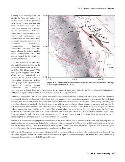
Figure 8. M7.2 El Mayor-Cucupah coseismic displacements (black arrows) from campaign<br />
GPS surveys.(Sandwell et al., 2010)<br />
processing and archiving longbaseline strain data. These data show intriguing trends during the initial months following the<br />
El Mayor Cucapah earthquake that may reflect slow slip on the San Jacinto fault.<br />
Oskin et al. developed a test to distinguish between two end-member models of long-term earthquake temporal clustering<br />
and applied it to the southern San Jacinto fault. One end-member is that clustering occurs due to changes in the brittle fault<br />
strength, and this would predict anti-correlated slip rate behavior of individual fault strands. Alternatively, clustering can<br />
result from changes in loading by the ductile lower crust which would predict correlated slip rate behavior of fault strands. To<br />
test these models they estimated slip rates at six sites along strands of the San Jacinto fault using two independent dating<br />
techniques to reduce potential bias in the results. Their results indicate there is a strong slip rate gradient along the San Jacinto<br />
fault with the slip rate decreasing to the southeast where slip is transferred from the Clark fault strand to the Coyote Creek<br />
fault and Salton Trough. The slip rates estimated for the Clark and Coyote Creek faults both show an increase over time<br />
suggesting that the change is due to an increase in fault zone loading.<br />
Weldon et al. completed mapping of the north branch of the San Andreas fault in the San Bernardino Valley and prepared for<br />
sample collection for cosmogenic dating to be conducted in the summer of 2011. These data will be used to determine the slip<br />
rate on this fault branch, a structure for which little slip rate information exists despite its important role in assessing the<br />
geodetic/geologic slip rate discrepancy and seismic hazard in this region.<br />
Kilb inspected the spectra for triggered earthquakes in the wavetrain of large amplitude teleseismic events and demonstrated<br />
that these triggered events are similar to typical shallow earthquakes in the same region (the Salton Sea) rather than having<br />
frequency characteristics expected of triggered tremor.<br />
2011 <strong>SCEC</strong> <strong>Annual</strong> <strong>Meeting</strong> | 45
