

Annual Meeting - SCEC.org
Annual Meeting - SCEC.org
Annual Meeting - SCEC.org

Create successful ePaper yourself
Turn your PDF publications into a flip-book with our unique Google optimized e-Paper software.
Report | <strong>SCEC</strong> Research Accomplishments<br />
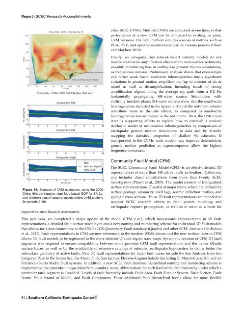
Figure 16. Example of CVM evaluation, using the 2008<br />
Chino Hills earthquake. (top) Map-based GOF for SA-2s,<br />
and (bottom) bias of spectral accelerations at 65 stations<br />
for periods 2-10s.<br />
regional seismic hazards assessment.<br />
54 | Southern California Earthquake Center<br />
other <strong>SCEC</strong> CVM's. Multiple CVM's are evaluated at one time, so that<br />
performance of a new CVM can be compared to existing, or prior,<br />
CVM versions. The GOF method includes a series of metrics, such as<br />
PGA, PGV, and spectral accelerations (SA) at various periods (Olsen<br />
and Mayhew 2010).<br />
Finally, we recognize that state-of-the-art velocity models do not<br />
resolve small-scale amplification effects in the near-surface sediments,<br />
possibly introducing bias in earthquake ground motion simulations,<br />
as frequencies increase. Preliminary analysis shows that even simple<br />
and rather weak fractal stochastic inhomogenities imply significant<br />
variations in ground motion amplifications (up to a factor of six or<br />
more) as well as de-amplification, including bands of strong<br />
amplification aligned along the average ray path from a 0-2 Hz<br />
horizontally propagating SH-wave source. Simulations with<br />
vertically incident planar SH-wave sources show that the small-scale<br />
heterogeneities included in the upper ~100m of the sediment column<br />
contribute more to the site effects, as compared to small-scale<br />
heterogeneities buried deeper in the sediments. Thus, the USR Focus<br />
Area is supporting efforts to explore how to establish a realistic<br />
stochastic model of near-surface inhomogeneities by comparison of<br />
earthquake ground motion simulations to data and by directly<br />
mapping the statistical properties of shallow Vs estimates. If<br />
incorporated in the CVMs, such models may improve deterministic<br />
ground motion prediction as supercomputers allow the highest<br />
frequency to increase.<br />
Community Fault Model (CFM)<br />
The <strong>SCEC</strong> Community Fault Model (CFM) is an object-oriented, 3D<br />
representation of more than 140 active faults in Southern California,<br />
and includes direct contributions from more than twenty <strong>SCEC</strong><br />
investigators (Plesch et al., 2007). The model consists of triangulated<br />
surface representations (T-surfs) of major faults, which are defined by<br />
surface geology, seismicity, well logs, seismic reflection profiles, and<br />
geologic cross sections. These 3D fault representations are intended to<br />
support <strong>SCEC</strong> research efforts in fault system modeling and<br />
earthquake rupture propagation, as well as to serve as a basis for<br />
This past year, we completed a major update of the model (CFM v.4.0), which incorporates improvements in 3D fault<br />
representations, a detailed fault surface trace layer, and a new naming and numbering scheme for individual 3D fault models<br />
that allows for direct connections to the USGS/CGS Quaternary Fault database (Qfaults) and other <strong>SCEC</strong> data sets (Nicholson<br />
et al., 2011). Fault representations in CFM are now referenced to the modern WG84 datum and the new surface layer in CFM<br />
allows 3D fault models to be registered to the more detailed Qfaults digital trace maps. Systematic revision of CFM 3D fault<br />
segments was required to ensure compatibility between some previous CFM fault representations and the newer Qfaults<br />
surface traces, as well as by the availability of extensive catalogs of relocated earthquake hypocenters to define better the<br />
subsurface geometry of active faults. New 3D fault representations for major fault zones include the San Andreas from San<br />
G<strong>org</strong>onio Pass to the Salton Sea, the Mecca Hills, San Jacinto, Elsinore-Laguna Salada (including El Mayor-Cucapah), and an<br />
Fernando/Sierra Madre fault systems. In addition, a new <strong>SCEC</strong> fault database hierarchical naming and numbering scheme is<br />
implemented that provides unique identifiers (number, name, abbreviation) for each level of the fault hierarchy under which a<br />
particular fault segment is classified. Levels of fault hierarchy include Fault Area, Fault Zone or System, Fault Section, Fault<br />
Name, Fault Strand or Model, and Fault Component. These additional fault hierarchical levels allow for more flexible
