

Annual Meeting - SCEC.org
Annual Meeting - SCEC.org
Annual Meeting - SCEC.org

Create successful ePaper yourself
Turn your PDF publications into a flip-book with our unique Google optimized e-Paper software.
Earthquake Geology<br />
<strong>SCEC</strong> Research Accomplishments | Report<br />
The <strong>SCEC</strong> geology disciplinary group coordinates diverse field-based investigations of the Southern California natural<br />
laboratory. The majority of Geology research accomplishments fall under two categories: (1) focused studies of the southern<br />
San Andreas and San Jacinto faults in coordination with the SoSAFE (Southern San Andreas Fault Evaluation) special project;<br />
and (2) studies of other portions of the southern California fault network aimed at a better understanding fault system<br />
behavior. Geology also contributes to earthquake response efforts and supports field observations related to several focusgroup<br />
activities (e.g., USR, WGCEP, FARM, GMP, LAD, CDM). Additional goals include longer-term slip rates and long,<br />
multi-event paleoseismologic records that have a high impact on seismic hazard assessments. In support to these efforts the<br />
Geology group coordinates geochronology infrastructure resources that are shared among various <strong>SCEC</strong>-sponsored projects.<br />
SoSAFE Special Project<br />
The primary goal of the SoSAFE project is to document the timing of large paleoearthquakes and amount of slip released by<br />
the southern San Andreas and San Jacinto faults over the past 2000 years. Additional goals include examination of longer-term<br />
slip rates and modeling studies that directly impact seismic hazard assessments. The SoSAFE project has become the<br />
dominant focus of geological investigations under <strong>SCEC</strong>3. The numerous accomplishments of this program are described in<br />
detail in the Special Projects section, below.<br />
Fault System Behavior<br />
A major emphasis of the Geology group has been to characterize patterns in fault system behavior that could significantly<br />
affect earthquake hazards. Recent efforts, focused on the San Cayetano-Ventura reverse fault system, aim to understand fault<br />
linkage and potential earthquake magnitude along the rapidly converging northern margin of the Ventura basin. Analysis of<br />
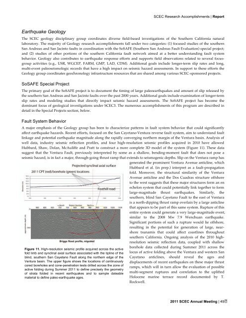
well data, industry seismic reflection profiles, and four high-resolution seismic profiles acquired in 2010 have allowed<br />
Hubbard, Shaw, Dolan, McAuliffe and Pratt to construct a more complete 3D model of the system (Figure 11). These data<br />
suggest that the Ventura Fault, previously interpreted by some as a shallow, bending-moment fault that does not pose a<br />
seismic hazard, is in fact a major, through-going thrust ramp that extends to seismogenic depths. Slip on the Ventura ramp has<br />
generated the prominent Ventura Avenue anticline, which<br />
Hubbard et al. (in prep.) interpret as a fault-propagation<br />
fold. Moreover, the structural similarity of the Ventura<br />
Avenue anticline and the Dos Cuadras structure offshore<br />
to the west suggests that these major structures form an en<br />
echelon system that could potentially link together to form<br />
large-magnitude thrust earthquakes. Similarly, the<br />
southern, blind San Cayetano Fault to the east of Ventura<br />
is a north-dipping thrust ramp overlain by a large anticline<br />
that appears to be part of this same system. Rupture of this<br />
entire system could generate a very large-magnitude event,<br />
similar to the 2008 Mw 7.9 Wenchuan earthquake.<br />
Significant portions of such a rupture would lie offshore,<br />
resulting in the potential for generation of large, nearshore<br />
tsunamis that could affect coastlines throughout<br />
southern California. Ongoing analysis of the 2010 highresolution<br />
seismic reflection data, coupled with shallow<br />
Figure 11. High-resolution seismic profile acquired across the active<br />
fold limb and synclinal axial surface associated with the tipline of the<br />
blind, southern San Cayetano Fault along the northern edge of the<br />
Ventura basin. The upper figure shows the locations of continuously<br />
cored boreholes and cone-penetration tests drilled across the zone of<br />
active folding during Summer 2011 to define precisely the geometry<br />
of strata folded in recent earthquakes and to sample dateable<br />
material to define paleo-earthquake ages.<br />
borehole data collected during Summer 2011 across the<br />
locus of active folding above the Ventura and western San<br />
Cayetano anticlines, should reveal the ages and<br />
displacements of recent earthquakes on these major thrust<br />
ramps, which will in turn allow the evaluation of possible<br />
multi-segment ruptures and correlation to the uplifted<br />
Holocene marine terrace record documented by T.<br />
Rockwell.<br />
2011 <strong>SCEC</strong> <strong>Annual</strong> <strong>Meeting</strong> | 49
