

Annual Meeting - SCEC.org
Annual Meeting - SCEC.org
Annual Meeting - SCEC.org

Create successful ePaper yourself
Turn your PDF publications into a flip-book with our unique Google optimized e-Paper software.
<strong>SCEC</strong> researchers are also attempting to<br />
determine how representative geologic slip<br />
rates are of the true slip rate of fault slip at<br />
depth. Although surface fault slip<br />
measurements are commonly used to infer<br />
seismic hazard, it has long been noted that<br />
surface slip during earthquakes is often<br />
smaller than slip at depth determined from<br />
inversion of geodetic and seismologic data. If<br />
this shallow slip deficit is due to significant<br />
off-fault deformation in the near-surface<br />
region, as suggested by earlier <strong>SCEC</strong>supported<br />
studies (e.g. Shelef and Oskin, 2010),<br />
then geological surface slip measurements will<br />
systematically underestimate fault slip at<br />
depth. Consequently, seismic hazard inferred<br />
from these measurements will also be<br />
underestimated. In an effort to determine if<br />
this shallow slip deficit varies as a function of<br />
measureable fault characteristics such as total<br />
fault slip or near-surface geology, Haravitch<br />
<strong>SCEC</strong> Research Accomplishments | Report<br />
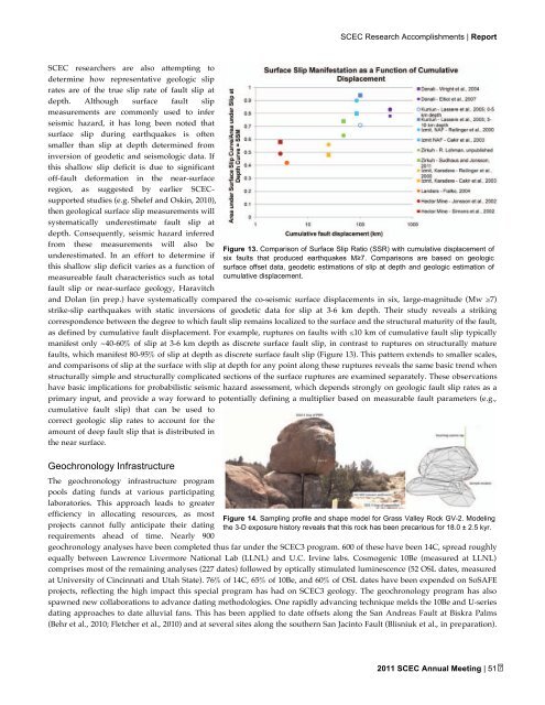
and Dolan (in prep.) have systematically compared the co-seismic surface displacements in six, large-magnitude (Mw ≥7)<br />
strike-slip earthquakes with static inversions of geodetic data for slip at 3-6 km depth. Their study reveals a striking<br />
correspondence between the degree to which fault slip remains localized to the surface and the structural maturity of the fault,<br />
as defined by cumulative fault displacement. For example, ruptures on faults with ≤10 km of cumulative fault slip typically<br />
manifest only ~40-60% of slip at 3-6 km depth as discrete surface fault slip, in contrast to ruptures on structurally mature<br />
faults, which manifest 80-95% of slip at depth as discrete surface fault slip (Figure 13). This pattern extends to smaller scales,<br />
and comparisons of slip at the surface with slip at depth for any point along these ruptures reveals the same basic trend when<br />
structurally simple and structurally complicated sections of the surface ruptures are examined separately. These observations<br />
have basic implications for probabilistic seismic hazard assessment, which depends strongly on geologic fault slip rates as a<br />
primary input, and provide a way forward to potentially defining a multiplier based on measurable fault parameters (e.g.,<br />
cumulative fault slip) that can be used to<br />
correct geologic slip rates to account for the<br />
amount of deep fault slip that is distributed in<br />
the near surface.<br />
Geochronology Infrastructure<br />
The geochronology infrastructure program<br />
pools dating funds at various participating<br />
laboratories. This approach leads to greater<br />
efficiency in allocating resources, as most<br />
projects cannot fully anticipate their dating<br />
requirements ahead of time. Nearly 900<br />
Figure 13. Comparison of Surface Slip Ratio (SSR) with cumulative displacement of<br />
six faults that produced earthquakes M≥7. Comparisons are based on geologic<br />
surface offset data, geodetic estimations of slip at depth and geologic estimation of<br />
cumulative displacement.<br />
Figure 14. Sampling profile and shape model for Grass Valley Rock GV-2. Modeling<br />
the 3-D exposure history reveals that this rock has been precarious for 18.0 ± 2.5 kyr.<br />
geochronology analyses have been completed thus far under the <strong>SCEC</strong>3 program. 600 of these have been 14C, spread roughly<br />
equally between Lawrence Livermore National Lab (LLNL) and U.C. Irvine labs. Cosmogenic 10Be (measured at LLNL)<br />
comprises most of the remaining analyses (227 dates) followed by optically stimulated luminescence (52 OSL dates, measured<br />
at University of Cincinnati and Utah State). 76% of 14C, 65% of 10Be, and 60% of OSL dates have been expended on SoSAFE<br />
projects, reflecting the high impact this special program has had on <strong>SCEC</strong>3 geology. The geochronology program has also<br />
spawned new collaborations to advance dating methodologies. One rapidly advancing technique melds the 10Be and U-series<br />
dating approaches to date alluvial fans. This has been applied to date offsets along the San Andreas Fault at Biskra Palms<br />
(Behr et al., 2010; Fletcher et al., 2010) and at several sites along the southern San Jacinto Fault (Blisniuk et al., in preparation).<br />
2011 <strong>SCEC</strong> <strong>Annual</strong> <strong>Meeting</strong> | 51
