

Annual Meeting - SCEC.org
Annual Meeting - SCEC.org
Annual Meeting - SCEC.org

You also want an ePaper? Increase the reach of your titles
YUMPU automatically turns print PDFs into web optimized ePapers that Google loves.
Workshops<br />
<strong>SCEC</strong> Research Accomplishments | Report<br />
<strong>SCEC</strong> supported three workshops related to crustal deformation modeling in 2010, covering (i) finite-element deformation<br />
modeling, (ii) integrating GPS into the UCERF3 process, and (iii) comparing earthquake simulators.<br />
The ninth annual Workshop on Crustal Deformation Modeling (June 14-18, 2010, in Golden Colorado) was co-sponsored by<br />
<strong>SCEC</strong> and the Computational Infrastructure for Geodynamics (CIG), and attracted 68 participants. The first two days were<br />
dedicated to training in the use of state-of-the-art finite-element codes for modeling crustal deformation with the remaining<br />
three days filled with science talks and discussions. See http://www.geodynamics.<strong>org</strong>/cig/workinggroups/short/workshops/cdm-<br />
10/agenda for the complete agenda and slides for all of the presentations. This year’s workshop included several presentations<br />
on the recent Haiti, Chile, and El Mayor-Cucapah earthquakes along with talks on fault and bulk rheologies with a focus on<br />
the base of the seismogenic zone. A discussion at the end of the workshop indicated overwhelming support for continuing the<br />
series of annual workshops. In early 2011 the <strong>org</strong>anizing committee decided that in order to keep the scientific agenda fresh<br />
and increase interest among leading researchers, we will switch to biannual meetings and skip holding a workshop in 2011.<br />
Instead we will hold a virtual (online) workshop in 2011 focused solely on training users in the use of PyLith and related codes<br />
for modeling crustal deformation. This experiment with online training should enable us to determine if this approach is<br />
effective and how to distribute our efforts in the future between in-person training at workshops versus online training.<br />
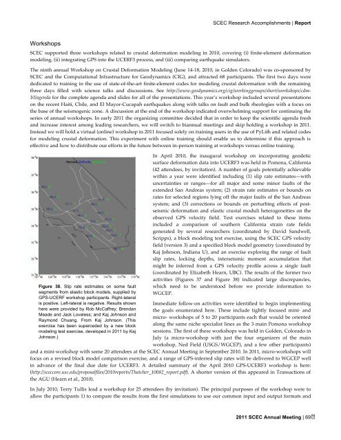
Figure 38. Slip rate estimates on some fault<br />
segments from elastic block models, supplied by<br />
GPS-UCERF workshop participants. Right-lateral<br />
is positive. Left-lateral is negative. Results shown<br />
here were provided by Rob McCaffrey; Brendan<br />
Meade and Jack Loveless; and Kaj Johnson and<br />
Raymond Chuang. From Kaj Johnson. (This<br />
exercise has been superceded by a new block<br />
modeling test exercise, developed in 2011 by Kaj<br />
Johnson.)<br />
In April 2010, the inaugural workshop on incorporating geodetic<br />
surface deformation data into UCERF3 was held in Pomona, California<br />
(42 attendees, by invitation). A number of goals potentially achievable<br />
within a year were identified including (1) slip rate estimates—with<br />
uncertainties or ranges—for all major and some minor faults of the<br />
extended San Andreas system; (2) strain rate estimates or bounds on<br />
rates for selected regions lying off the major faults of the San Andreas<br />
system; and (3) corrections or bounds on perturbing effects of postseismic<br />
deformation and elastic crustal moduli heterogeneities on the<br />
observed GPS velocity field. Test exercises related to these items<br />
included a comparison of southern California strain rate fields<br />
generated by several researchers (coordinated by David Sandwell,<br />
Scripps), a block modeling test exercise, using the <strong>SCEC</strong> GPS velocity<br />
field (version 3) and a specified block model geometry (coordinated by<br />
Kaj Johnson, Indiana U), and an exercise exploring the range of fault<br />
slip rates, locking depths, interseismic moment accumulation that<br />
might be inferred from a GPS velocity profile across a single fault<br />
(coordinated by Elizabeth Hearn, UBC). The results of the former two<br />
activities (Figures 37 and Figure 38) indicated large discrepancies,<br />
which need to be understood before we provide information to<br />
WGCEP.<br />
Immediate follow-on activities were identified to begin implementing<br />
the goals enumerated here. These include tightly focused mini- and<br />
micro- workshops of 5 to 20 participants each that would be oriented<br />
along the same niche specialist lines as the 3 main Pomona workshop<br />
sessions. The first of these workshops was held in Golden, Colorado in<br />
July (a micro-workshop with just the four <strong>org</strong>anizers of the main<br />
workshop, Ned Field (USGS/WGCEP), and a few other participants)<br />
and a mini-workshop with some 20 attendees at the <strong>SCEC</strong> <strong>Annual</strong> <strong>Meeting</strong> in September 2010. In 2011, micro-workshops will<br />
focus on a revised block model comparison exercise, and a range of GPS-inferred slip rates will be delivered to WGCEP well<br />
in advance of the final due date for UCERF3. A detailed summary of the April 2010 GPS-UCERF3 workshop is here:<br />
(http://sceccore.usc.edu/proposalfiles/2010reports/Thatcher_10082_report.pdf). A shorter version of this appeared in Transactions of<br />
the AGU (Hearn et al., 2010).<br />
In July 2010, Terry Tullis lead a workshop for 25 attendees (by invitation). The principal purposes of the workshop were to<br />
allow the participants 1) to compare the results from the first simulations to use our common input and output formats and<br />
2011 <strong>SCEC</strong> <strong>Annual</strong> <strong>Meeting</strong> | 69
