

Ninth International Conference on Permafrost ... - IARC Research
Ninth International Conference on Permafrost ... - IARC Research
Ninth International Conference on Permafrost ... - IARC Research

Create successful ePaper yourself
Turn your PDF publications into a flip-book with our unique Google optimized e-Paper software.
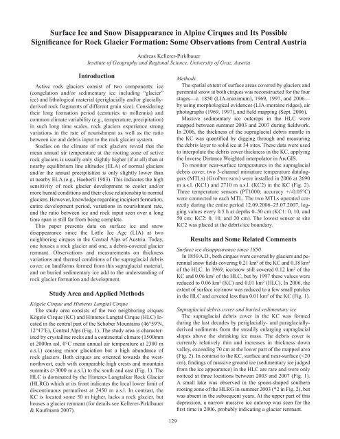
Surface Ice and Snow Disappearance in Alpine Cirques and Its PossibleSignificance for Rock Glacier Formati<strong>on</strong>: Some Observati<strong>on</strong>s from Central AustriaAndreas Kellerer-PirklbauerInstitute of Geography and Regi<strong>on</strong>al Science, University of Graz, AustriaIntroducti<strong>on</strong>Active rock glaciers c<strong>on</strong>sist of two comp<strong>on</strong>ents: ice(c<strong>on</strong>gelati<strong>on</strong> and/or sedimentary ice including “glacier”ice) and lithological material (periglacially and/or glaciallyderivedrock fragments of different grain size). C<strong>on</strong>sideringtheir l<strong>on</strong>g formati<strong>on</strong> period (centuries to millennia) andcomm<strong>on</strong> climate variability (e.g., temperature, precipitati<strong>on</strong>)in such l<strong>on</strong>g time scales, rock glaciers experience str<strong>on</strong>gvariati<strong>on</strong>s in the rate of nourishment as well as the ratiobetween ice and debris input to the rock glacier system.Studies <strong>on</strong> the climate of rock glaciers reveal that themean annual air temperature at the rooting z<strong>on</strong>e of activerock glaciers is usually <strong>on</strong>ly slightly higher (if at all) than atnearby equilibrium line altitudes (ELA) of normal glaciersand/or the annual precipitati<strong>on</strong> is <strong>on</strong>ly slightly lower thanat nearby ELA (e.g., Haeberli 1983). This indicates the highsensitivity of rock glacier development to cooler and/ormore humid c<strong>on</strong>diti<strong>on</strong>s and their close relati<strong>on</strong>ship to normalglaciers. However, knowledge regarding incipient formati<strong>on</strong>,entire development period, variati<strong>on</strong>s in nourishment rate,and the ratio between ice and rock input seen over a l<strong>on</strong>gtime span is still far from being complete.This paper presents data <strong>on</strong> surface ice and snowdisappearance since the Little Ice Age (LIA) at tw<strong>on</strong>eighboring cirques in the Central Alps of Austria. Today,<strong>on</strong>e houses a rock glacier and <strong>on</strong>e, a debris-covered glacierremnant. Observati<strong>on</strong>s and measurements <strong>on</strong> thicknessvariati<strong>on</strong>s and thermal c<strong>on</strong>diti<strong>on</strong>s of the supraglacial debriscover, <strong>on</strong> landforms formed from this supraglacial material,and <strong>on</strong> buried sedimentary ice add to the understanding ofrock glacier formati<strong>on</strong> and development.Study Area and Applied MethodsKögele Cirque and Hinteres Langtal CirqueThe study area c<strong>on</strong>sists of the two neighboring cirquesKögele Cirque (KC) and Hinteres Langtal Cirque (HLC) locatedin the central part of the Schober Mountains (46°59′N,12°47′E), Central Alps (Fig. 1). The study area is characterizedby crystalline rocks and a c<strong>on</strong>tinental climate (1500mmat 2000m asl, 0°C mean annual air temperature at 2300 ma.s.l.) causing minor glaciati<strong>on</strong> but a high abundance ofrock glaciers. Both cirques are oriented towards the westnorthwest,each with comparable high crests and mountainsummits (>3000 m a.s.l.) to the south and east (Fig. 1). TheHLC is dominated by the Hinteres Langtalkar Rock Glacier(HLRG) which at its fr<strong>on</strong>t indicates the local lower limit ofdisc<strong>on</strong>tinuous permafrost at 2450 m a.s.l. In c<strong>on</strong>trast, theKC is located some 50 m higher, lacks a rock glacier, buthouses a glacier remnant (for details see Kellerer-Pirklbauer& Kaufmann 2007).MethodsThe spatial extent of surface areas covered by glaciers andperennial snow at both cirques was rec<strong>on</strong>structed for the fourstages—c. 1850 (LIA-maximum), 1969, 1997, and 2006—by using morphological evidences (LIA-moraine ridges), airphotographs (1969, 1997), and field mapping (Sept. 2006).Massive sedimentary ice outcrops in the HLC weremapped between summer 2003 and 2007 during fieldwork.In 2006, the thickness of the supraglacial debris mantle inthe KC was quantified by digging through and measuringthe debris layer to solid ice at 34 sites. These data were usedto interpolate the debris cover thickness in the KC, applyingthe Inverse Distance Weighted interpolator in ArcGIS.To m<strong>on</strong>itor near-surface temperatures in the supraglacialdebris cover, two 3-channel miniature temperature dataloggers(MTLs) (Ge oPr e c i s i o n) were installed in 2006 at 2690m a.s.l. (KC1) and 2710 m a.s.l. (KC2) in the KC (Fig. 2).Three temperature sensors (PT1000; accuracy +/-0.05°C)were c<strong>on</strong>nected to each MTL. The two MTLs operated correctlyduring the entire period 12.09.2006–25.07.2007, loggingvalues every 0.5 h at depths 0–50 cm (KC1: 0, 10, and50 cm; KC2: 0, 10, and 20 cm). The lowest sensor at siteKC2 was placed at the debris/ice boundary.Results and Some Related CommentsSurface ice disappearance since 1850In 1850 A.D., both cirques were covered by glaciers and perennialsnow fields covering 0.21 km² of the KC and 0.18 km²of the HLC. In 1969, ice/snow still covered 0.12 km² of theKC and 0.06 km² of the HLC, but by 1997 these values werereduced to 0.06 km² (KC) and 0.01 km² (HLC). In 2006, theextent of surface ice/snow was reduced to a few small patchesin the HLC and covered less than 0.01 km² of the KC (Fig. 1).Supraglacial debris cover and buried sedimentary iceThe supraglacial debris cover in the KC was formedduring the last decades by periglacially- and paraglaciallyderivedsediments from the steadily enlarging supraglacialslopes above the shrinking ice mass. The debris cover iscurrently relatively thin and increases in thickness downvalley, exceeding 70 cm at the lower part of the mapped area(Fig. 2). In c<strong>on</strong>trast to the KC, surface and near-surface (


