

Ninth International Conference on Permafrost ... - IARC Research
Ninth International Conference on Permafrost ... - IARC Research
Ninth International Conference on Permafrost ... - IARC Research

Create successful ePaper yourself
Turn your PDF publications into a flip-book with our unique Google optimized e-Paper software.
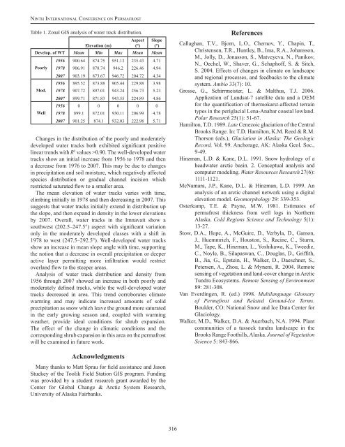
Ni n t h In t e r n at i o n a l Co n f e r e n c e o n Pe r m a f r o s tTable 1. Z<strong>on</strong>al GIS analysis of water track distributi<strong>on</strong>.Elevati<strong>on</strong> (m)Aspect(°)Slope(°)Develop. of WT Mean Min Max Mean MeanPoorlyMod.Well1956 900.64 874.75 951.13 235.43 4.711978 906.91 878.74 946.2 226.46 4.942007 903.19 873.67 946.72 204.72 4.341956 895.52 873.88 905.44 229.88 3.981978 907.72 897.01 943.24 256.73 5.232007 899.71 871.83 943.55 224.89 4.861956 0 0 0 0 01978 899.1 872.01 930.11 206.99 4.782007 901.25 874.1 932.03 222.98 5.71Changes in the distributi<strong>on</strong> of the poorly and moderatelydeveloped water tracks both exhibited significant positivelinear trends with R 2 values >0.90. The well-developed watertracks show an initial increase from 1956 to 1978 and thena decrease from 1976 to 2007. This may be due to changesin precipitati<strong>on</strong> and soil moisture, which negatively affectedspecies distributi<strong>on</strong> or gradual channel incisi<strong>on</strong> whichrestricted saturated flow to a smaller area.The mean elevati<strong>on</strong> of water tracks varies with time,climbing initially in 1978 and then decreasing in 2007. Thissuggests that water tracks initially extend in distributi<strong>on</strong> upthe slope, and then expand in density in the lower elevati<strong>on</strong>sby 2007. Overall, water tracks in the Imnavait show asouthwest (202.5–247.5°) aspect with significant variati<strong>on</strong><strong>on</strong>ly in the moderately developed classes with a shift in1978 to west (247.5–292.5°). Well-developed water tracksshow an increase in mean slope angle with time, supportingthe noti<strong>on</strong> that a decrease in overall precipitati<strong>on</strong> or deeperactive layer permitting more infiltrati<strong>on</strong> would restrictoverland flow to the steeper areas.Analysis of water track distributi<strong>on</strong> and density from1956 through 2007 showed an increase in both poorly andmoderately defined tracks, while the well-developed watertracks decreased in area. This trend corroborates climatewarming and may indicate increased amounts of solidprecipitati<strong>on</strong> as snow which leave the ground more saturatedin the early growing seas<strong>on</strong> and, coupled with warmingweather, provide ideal c<strong>on</strong>diti<strong>on</strong>s for shrub expansi<strong>on</strong>.The effect of the change in climatic c<strong>on</strong>diti<strong>on</strong>s and thecorresp<strong>on</strong>ding shrub expansi<strong>on</strong> in this area <strong>on</strong> the permafrostwill be examined in future work.ReferencesCallaghan, T.V., Bjorn, L.O., Chernov, Y., Chapin, T.,Christensen, T.R., Huntley, B., Ima, R.A., Johanss<strong>on</strong>,M., Jolly, D., J<strong>on</strong>ass<strong>on</strong>, S., Matveyeva, N., Panikov,N., Oechel, W., Shaver, G., Schaphoff, S. & Sitch,S. 2004. Effects of changes in climate <strong>on</strong> landscapeand regi<strong>on</strong>al processes, and feedbacks to the climatesystem. Ambio 33(7): 10.Grosse, G., Schirrmeister, L. & Malthus, T.J. 2006.Applicati<strong>on</strong> of Landsat-7 satellite data and a DEMfor the quantificati<strong>on</strong> of thermokarst-affected terraintypes in the periglacial Lena-Anabar coastal lowland.Polar <strong>Research</strong> 25(1): 51-67.Hamilt<strong>on</strong>, T.D. 1989. Late Cenezoic glaciati<strong>on</strong> of the CentralBrooks Range. In: T.D. Hamilt<strong>on</strong>, K.M. Reed & R.M.Thors<strong>on</strong> (eds.), Glaciati<strong>on</strong> in Alaska: The GeologicRecord, Vol. 99. Anchorage, AK: Alaska Geol. Soc.,9-49.Hinzman, L.D. & Kane, D.L. 1991. Snow hydrology of aheadwater arctic basin. 2. C<strong>on</strong>ceptual analysis andcomputer modeling. Water Resources <strong>Research</strong> 27(6):1111-1121.McNamara, J.P., Kane, D.L. & Hinzman, L.D. 1999. Ananalysis of an arctic channel network using a digitalelevati<strong>on</strong> model. Geomorphology 29: 339-353.Osterkamp, T.E. & Payne, M.W. 1981. Estimates ofpermafrost thickness from well logs in NorthernAlaska. Cold Regi<strong>on</strong>s Science and Technology 5(1):13-27.Stow, D.A., Hope, A., McGuire, D., Verbyla, D., Gam<strong>on</strong>,J., Huemmrich, F., Houst<strong>on</strong>, S., Racine, C., Sturm,M., Tape, K., Hinzman, L., Yoshikawa, K., Tweedie,C., Noyle, B., Silapaswan, C., Douglas, D., Griffith,B., Jia, G., Epstein, H., Walker, D., Daeschner, S.,Petersen, A., Zhou, L. & Myneni, R. 2004. Remotesensing of vegetati<strong>on</strong> and land-cover change in ArcticTundra Ecosystems. Remote Sensing of Envir<strong>on</strong>ment89: 281-308.Van Everdingen, R. (ed.) 1998. Multilanguage Glossaryof <strong>Permafrost</strong> and Related Ground-Ice Terms.Boulder, CO: Nati<strong>on</strong>al Snow and Ice Data Center forGlaciology.Walker, M.D., Walker, D.A. & Auerbach, N.A. 1994. Plantcommunities of a tussock tundra landscape in theBrooks Range Foothills, Alaska. Journal of Vegetati<strong>on</strong>Science 5: 843-866.AcknowledgmentsMany thanks to Matt Sprau for field assistance and Jas<strong>on</strong>Stuckey of the Toolik Field Stati<strong>on</strong> GIS program. Fundingwas provided by a student research grant awarded by theCenter for Global Change & Arctic System <strong>Research</strong>,University of Alaska Fairbanks.316


