

Ninth International Conference on Permafrost ... - IARC Research
Ninth International Conference on Permafrost ... - IARC Research
Ninth International Conference on Permafrost ... - IARC Research

Create successful ePaper yourself
Turn your PDF publications into a flip-book with our unique Google optimized e-Paper software.
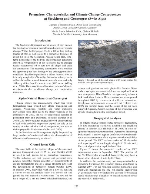
<strong>Permafrost</strong> Characteristics and Climate Change C<strong>on</strong>sequencesat Stockhorn and Gornergrat (Swiss Alps)Introducti<strong>on</strong>Clemens C<strong>on</strong>stantin Maag, Oliver Wild, Lorenz KingJustus-Liebig-University Giessen, GermanyMartin Baum, Sebastian Klein, Christin HilbichFriedrich-Schiller-University Jena, GermanyThe Stockhorn-Gornergrat tourist area is of high interestfor the study of mountain permafrost and aspects of climatechange. Within the EU-project PACE, a 100 m deep drillinglocated at 3405 m a.s.l. points to a permafrost thickness ofabout 170 m at the Stockhorn Plateau. Since then, l<strong>on</strong>gtermm<strong>on</strong>itoring of the bedrock and permafrost c<strong>on</strong>diti<strong>on</strong>sstarted. A reorganizati<strong>on</strong> of the ski regi<strong>on</strong> due to changedtourist expectati<strong>on</strong>s led to both new ski slopes and cablecar c<strong>on</strong>necti<strong>on</strong>s. The necessary c<strong>on</strong>structi<strong>on</strong> work providesthe opportunity for new findings of the existing permafrostc<strong>on</strong>diti<strong>on</strong>s. Stockhorn qualifies as a salient research area, asit is <strong>on</strong>ly marginally affected by the tourist industry yet iswithin the well-examined Zermatt research area, and <strong>on</strong>ly10 km by airline from Kleinmatterhorn (3883 m a.s.l.) (Kinget al. 2008). These c<strong>on</strong>diti<strong>on</strong>s allow observati<strong>on</strong> of climaticdevelopments due to climate change and c<strong>on</strong>structi<strong>on</strong>measures.Alpine Natural Hazards at GornergratClimate change and accompanying effects like risingtemperatures have created new alpine phenomena anddangers. Avalanches, rockfalls and water inclusi<strong>on</strong>smay appear more often due to the steady warming of theatmosphere. In 2003, the rise of temperatures resulted inpermafrost thaw and excepti<strong>on</strong>al rockfalls (Gruber et al2004b). As further research projects showed, characteristicsof rock walls and their temperature depend not <strong>on</strong>ly <strong>on</strong> thequality of solar radiati<strong>on</strong> and air temperature, but also <strong>on</strong>their topographic distributi<strong>on</strong> (Gruber et al. 2004).As the Stockhorn and Gornergrat are highly frequented bylarge numbers of tourists and skiers, the characteristics ofthis area must be c<strong>on</strong>stantly m<strong>on</strong>itored.Ground Ice at KelleThe area Kelle at the northern slopes of the east–westrunning Gornergrat crest (3135 m) and Hohtälli (3286m a.s.l.) is well known for its permafrost occurrences.Visible indicators are rock glaciers and perennial snowpatches. Scientific studies c<strong>on</strong>sisted of measurements ofground temperatures and BTS values (Philippi 2003) andthe development of permafrost models (Gruber 2000).In summer 2007, excavati<strong>on</strong> work for a new ski run anda culvert system for artificial snow was carried out, andground ice was exposed at various sites. The new ski runhas a length of 2.5 km and 300 m altitudinal difference, andFigure 1. Ground ice of the rock glacier with water c<strong>on</strong>duit forartificial snow producti<strong>on</strong> (lower right).crosses rock glaciers and rock glacier-like features. Nearsurfacetop layers were removed down to a depth of 8 to 10m at some places. This offered the rare opportunity to have alook inside these features. The excavati<strong>on</strong> was accompaniedthroughout 2007 by researchers of different universities.Geophysical measurements were carried out (Hilbich et al.2007), ice samples taken, and the course of the ski tracksurveyed (Giessen, Zurich). Melting of the ground ice wasalready observed during the c<strong>on</strong>structi<strong>on</strong> period.Geophysical AnalysesIn order to observe climate-related permafrost degradati<strong>on</strong>,a fix ERT m<strong>on</strong>itoring system was installed at the Stockhornplateau in summer 2005 (Hilbich et al. 2008) in close cooperati<strong>on</strong>with the PERMOS network (<strong>Permafrost</strong> M<strong>on</strong>itoringSwitzerland). It enables regular (preferably seas<strong>on</strong>al) semiautomaticmeasurements of the apparent electrical resistivityof the ground. The ERT secti<strong>on</strong> c<strong>on</strong>sists of 55 electrodeswith a spacing of 2 m, resulting in a length of 108 m in total.The vertical penetrati<strong>on</strong> depth is about 20 m.Figure 2 shows the computed results of an ERTmeasurement made in September 2007. The positi<strong>on</strong> ofthe PACE boreholes are marked; however they may have alateral offset of about 10 m to the ERT line.In additi<strong>on</strong>, the electrode array was complemented by acoinciding fix transect for refracti<strong>on</strong> seismic m<strong>on</strong>itoring insummer 2007. For the refracti<strong>on</strong> seismic m<strong>on</strong>itoring, <strong>on</strong>eshort (2 m spacing) and <strong>on</strong>e l<strong>on</strong>g (4 m spacing) secti<strong>on</strong> with24 geoph<strong>on</strong>es each were installed to account for both highspatial resoluti<strong>on</strong> (at a length of 46 m) and extensi<strong>on</strong> acrossthe whole ERT line (96 m).195


