

Ninth International Conference on Permafrost ... - IARC Research
Ninth International Conference on Permafrost ... - IARC Research
Ninth International Conference on Permafrost ... - IARC Research

You also want an ePaper? Increase the reach of your titles
YUMPU automatically turns print PDFs into web optimized ePapers that Google loves.
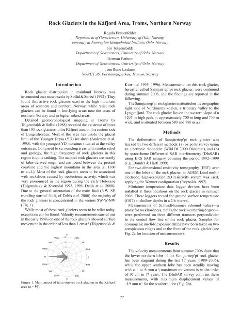
Rock Glaciers in the Kåfjord Area, Troms, Northern NorwayRegula FrauenfelderDepartment of Geosciences, University of Oslo, Norway,currently at Norwegian Geotechnical Institute, Oslo, NorwayJ<strong>on</strong> TolgensbakkDepartment of Geosciences, University of Oslo, NorwayHerman FarbrotDepartment of Geosciences, University of Oslo, NorwayTom Rune LauknesNORUT AS, Forskningsparken, Tromsø, NorwayIntroducti<strong>on</strong>Rock glacier distributi<strong>on</strong> in mainland Norway wasinventoried <strong>on</strong> a macro scale by Sollid & Sørbel (1992). Theyfound that active rock glaciers exist in the high mountainareas of southern and northern Norway, while relict rockglaciers can be found in low-lying areas near the coast ofnorthern Norway and in higher inland areas.Detailed geomorphological mapping in Troms byTolgensbakk & Sollid (1988) revealed the existence of morethan 100 rock glaciers in the Kåfjord area <strong>on</strong> the eastern sideof Lyngenfjorden. Most of the area lies inside the glaciallimit of the Younger Dryas (YD) ice sheet (Andersen et al.1995), with the youngest YD moraines situated at the valleyentrances. Compared to surrounding areas with similar reliefand geology, the high frequency of rock glaciers in thisregi<strong>on</strong> is quite striking. The mapped rock glaciers are mostlyof talus-derived origin and are found between the presentcoastline and the highest mountains in the area (c. 1360m a.s.l.). Most of the rock glaciers seem to be associatedwith rockslides caused by neotect<strong>on</strong>ic activity, which wasvery pr<strong>on</strong>ounced in the regi<strong>on</strong> during the early Holocene(Tolgensbakk & Kverndal 1995, 1996, Dehls et al. 2000).Due to the general orientati<strong>on</strong> of the main fault (NW–SEtrending normal fault, cf. Dehls et al. 2000), the majority ofthe rock glaciers is c<strong>on</strong>centrated in the sectors SW-W-NW(Fig. 1).While most of these rock glaciers seem to be relict today,excepti<strong>on</strong>s can be found. Velocity measurements carried outin the early 1990s <strong>on</strong> <strong>on</strong>e of the rock glaciers showed surfacemovement in the order of less than 1 cm a -1 (Tolgensbakk &Kverndal 1995, 1996). Measurements <strong>on</strong> this rock glacier,hereafter called Sannjarriep’pi rock glacier, were c<strong>on</strong>tinuedduring summer 2006, and the findings are reported in thefollowing.The Sannjarriep’pi rock glacier is situated <strong>on</strong> the orographicright side of Nordmannvikdalen, a tributary valley to theLyngenfjord. The rock glacier lies <strong>on</strong> the western slope of a1207 m high peak, is approximately 700 m l<strong>on</strong>g and 700 mwide, and is situated between 580 and 780 m a.s.l.MethodsThe deformati<strong>on</strong> of Sannjarriep’pi rock glacier wastracked by two different methods: (a) by polar survey usingan electr<strong>on</strong>ic theodolite (Wild DI 3000 Distomat), and (b)by space-borne Differential SAR interferometry (DInSAR)using ERS SAR imagery covering the period 1992–1999(e.g., Bamler & Hartl 1999).For two-dimensi<strong>on</strong>al resistivity tomography (ERT) over<strong>on</strong>e of the lobes of the rock glacier, an ABEM Lund multielectrode,high-resoluti<strong>on</strong> 2D resistivity system was used,applying the Wenner c<strong>on</strong>figurati<strong>on</strong> (Reynolds 1997).Miniature temperature data logger devices have beeninstalled at three locati<strong>on</strong>s <strong>on</strong> the rock glacier in summer2006. These loggers record the ground surface temperature(GST) at shallow depths in a 2 h interval.Measurements of Schmidt-hammer rebound values—aproxy for rock hardness, that is, the rock weathering degree—were performed <strong>on</strong> three different transects perpendicularto the central flow line of the rock glacier. Samples forcosmogenic nuclide exposure dating have been taken <strong>on</strong> twoc<strong>on</strong>spicuous ridges and at the fr<strong>on</strong>t of the rock glacier (seeFig. 2a for locati<strong>on</strong> of measurements).ResultsFigure 1. Main aspect of talus-derived rock glaciers in the Kåfjordarea (n = 59).The velocity measurements from summer 2006 show thatthe lower northern lobe of the Sannjarriep’pi rock glacierhas been stagnant during the last 17 years (1989–2006),while the upper southern lobe has been steadily movingwith c. 1 to 6 mm a -1 ; maximum movement is in the orderof 10 cm in 17 years. The DInSAR survey c<strong>on</strong>firms thesemeasurements, with maximum displacement values of-4.9 mm a -1 for the southern lobe (Fig. 2b).77


