annexures - Indian Institute of Technology Roorkee
annexures - Indian Institute of Technology Roorkee
annexures - Indian Institute of Technology Roorkee

You also want an ePaper? Increase the reach of your titles
YUMPU automatically turns print PDFs into web optimized ePapers that Google loves.
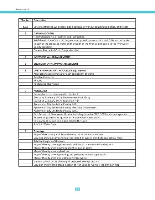
Annexure - 10ChaptersDescription3.3.3 LCC <strong>of</strong> centralized v/s decentralized options for various combination <strong>of</strong> no. <strong>of</strong> districts3 OPTION ADOPTEDFinally deciding no. <strong>of</strong> districts and JustificationBrief description <strong>of</strong> each district, works proposed, approx capital and O&M cost <strong>of</strong> worksImpact <strong>of</strong> the proposed works on the health <strong>of</strong> the river, as compared to the river waterquality standardsGeneral Abstract <strong>of</strong> Cost (Comprehensive)4 INSTITUTIONAL ARRANGEMENTS5 ENVIRONMENTAL IMPACT ASSESSMENT6 COST ESTIMATES AND RESOURCE REQUIREMNTAbstract <strong>of</strong> cost estimates for each component <strong>of</strong> worksPossible ResourcesPhasingResource recovery plan7 ANNEXURESData collected as mentioned in chapter 2Executive Summary <strong>of</strong> City Development Plan, if anyExecutive Summary <strong>of</strong> City Sanitation PlanApproval <strong>of</strong> City Sanitation Plan by ULBApproval <strong>of</strong> City Sanitation Plan by the State GovernmentApproval <strong>of</strong> City Sanitation Plan by NRCDTest Reports <strong>of</strong> River Water Quality, including those by CPCB, SPCB and other agenciesReports <strong>of</strong> quantity and quality <strong>of</strong> waste water in the drainsRates <strong>of</strong> Land Acquisition in and around the townSub Soil Water Data8 DrawingsMap <strong>of</strong> the Country and State showing the location <strong>of</strong> the townCity map showing surrounding areas (based on survey <strong>of</strong> India topographical map)Satellite imagery <strong>of</strong> the townMap <strong>of</strong> the city showing River Basin and details as mentioned in chapter 3Map <strong>of</strong> the city showing drains and their outfall pointsMap <strong>of</strong> the city showing land useMap <strong>of</strong> the city showing existing and proposed `water supply worksMap <strong>of</strong> the city showing existing sewerage worksGeneral Layout <strong>of</strong> city showing all proposed sewage districtsCity plan showing the broad location <strong>of</strong> Non Sewage works ij the city plan map156