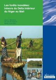
Delta intérieur Du fleuve niger
Delta intérieur Du fleuve niger
Delta intérieur Du fleuve niger

You also want an ePaper? Increase the reach of your titles
YUMPU automatically turns print PDFs into web optimized ePapers that Google loves.
232 Summary<br />
summarY<br />
In 1998, Wetlands International took the initiative to<br />
launch a new project in one of the largest floodplains of<br />
the world: the Inner Niger <strong>Delta</strong> in Mali. Situated in the<br />
Sahel, the Inner <strong>Delta</strong> of the Niger can be characterised as<br />
a seasonal, river-fed floodplain, of which the flooded surface<br />
varies from year to year, being 30,000 - 40,000 km 2<br />
in most years. The area provides a daily base for subsistence<br />
to about one million people who try to make a living as<br />
fishermen, cattle breeders or farmers. Since time immemorial,<br />
local communities have exploited the available natural<br />
resources in the <strong>Delta</strong>. Carrying the burden of periods of<br />
severe drought in the years 1970 and 1980, with at the<br />
same time an expanding local population, the <strong>Delta</strong> is<br />
facing a growing pressure on natural resources. Even so,<br />
the <strong>Delta</strong> is internationally renowned for its outstanding<br />
natural resources and biodiversity. Biological resources<br />
concern primarily the large concentrations of waterbirds<br />
which congregate in the <strong>Delta</strong>. Large fauna, such as ungulates<br />
and reptiles (lizards, crocodiles, etc.) are on the edge<br />
of extinction in the <strong>Delta</strong>, though Hippo’s Hippopotamus<br />
amphibius and Manatees Trichechus senegalensis are still present in<br />
low numbers.<br />
With the initiation of the current project in August 1998,<br />
Wetlands International started a process in the Inner Niger<br />
<strong>Delta</strong> which addresses all stakeholders involved in the use<br />
and management of natural resources: local populations,<br />
Malian authorities and relevant NGO’s. Using the outcomes<br />
of past projects, this project served as a first phase, in<br />
which a reconnaissance was carried out into the actual<br />
socio-economic organisation and biodiversity. At the same<br />
time, the project aimed at identifying bottlenecks and<br />
potentials for a sustainable use of natural resources in the<br />
<strong>Delta</strong>. The project did not include fish and related aspects,<br />
however, since this has recently been a topic of extensive<br />
study by IER, IRD and OPM. The current project forms a<br />
solid basis for an integral approach in which local populations<br />
play a key role, supported by governmental organisations<br />
and NGO’s where appropriate. Such an approach fits<br />
well in the decentralisation policy of the Malian government.<br />
This project was supported by the Malian and <strong>Du</strong>tch<br />
governments, and was financed within the framework of<br />
the <strong>Du</strong>tch PIN-OS funds. In this report the results of the<br />
project are briefly presented.<br />
Objectives and organisation<br />
The main short-term objectives of the project were:<br />
• To establish long-term collaboration with Malian organisations<br />
(capacity building and transfer of specific<br />
wetland knowledge and information) and to train<br />
Malian project-participants in survey-techniques and<br />
research methods;<br />
• To develop a knowledge of the hydrological and ecological<br />
relationships by, amongst others, executing waterbird<br />
surveys and ecological research in the central part<br />
of the Inner Niger <strong>Delta</strong>;<br />
• To develop a monitoring plan for waterbirds, which<br />
would be suitable for monitoring changes in environmental<br />
conditions and the use of waterbirds as indicators;<br />
• To contribute to the development of a management plan.<br />
The project was built on existing knowledge and linked up,<br />
where possible, with running projects in the <strong>Delta</strong>. The<br />
project in the Inner Niger <strong>Delta</strong> was led by Wetlands<br />
International in Sévaré in close co-operation with the<br />
Malian authorities, A&W ecological consultants (co-ordination<br />
of and participation in the Biological Research<br />
Programme), and the <strong>Du</strong>tch research institutes RIZA and<br />
Alterra (support and input of specific wetland-ecology<br />
knowledge). The Romanian Donau <strong>Delta</strong> National Institute<br />
(DDNI) provided remote sensing support. The project staff<br />
operated from Sévaré with a field station in Akka, on the<br />
border of Lac Debo in the central part of the <strong>Delta</strong>.<br />
The Inner Niger <strong>Delta</strong> - hydrology<br />
The Inner Niger <strong>Delta</strong> in Mali is one of the largest floodplains<br />
in Africa, intensively used by local populations for<br />
their subsistence. Rising in the mountainous regions in<br />
Guinea, the river Niger flows through Mali, forming an<br />
immense delta between Ké Macina and Tombouctou.<br />
Though local rainfall is concentrated mainly in July and<br />
August, the maximum of the flood is reached in November-<br />
December, depending on the height of the flood. The water<br />
charge of the Niger is subject to a large annual fluctuation<br />
and as a consequence the inundated area varies also: in the<br />
last century the inundated area varied between 9,500 km 2<br />
in 1984 and 44,000 km 2 in 1957. Recent series of years<br />
with severe drought occurred in the 1970’s, 1980’s and<br />
early 1990’s. From earlier studies it is known that the production<br />
of fish – the main protein source for the local<br />
populations – is strongly related to the inundated surface<br />
area. The means of subsistence for local populations thus<br />
depends heavily on the height of the flood: water rules life<br />
in a real sense.<br />
Remote sensing data in this report show that a series of low<br />
or higher floods lead to a shift in the zoning of the vegetation.<br />
Also, local people tend to shift their rice cultures to<br />
more suitable places during long periods of drought. Flood<br />
forests, which still remained in the lower parts of the <strong>Delta</strong>,<br />
were cleared for rice cultivation<br />
Socio-economic organisation and the use of natural<br />
resources<br />
In the course of the centuries a complex system of land use<br />
and management of natural resources (the Dina law) has<br />
been developed in the <strong>Delta</strong>, in which different ethnic<br />
groups are involved as herdsmen and fishermen. Up to<br />
now, this traditional system has played an important role in<br />
controlling the use of natural resources by the local communities.<br />
Together with the decentralisation policy of the<br />
Malian government, this means that the involvement of<br />
local communities from the start in any project is essential<br />
for a successful approach. One of the first steps in the project<br />
therefore was to initiate the collaboration with the local<br />
populations in the <strong>Delta</strong>.<br />
Since working in the entire <strong>Delta</strong> wouldn’t be possible,<br />
given its scale and logistic constraints, Wetlands<br />
International sought the collaboration of 28 villages in the<br />
<strong>Delta</strong> (partner villages). From an extensive inventory taken<br />
in these villages, it appeared that in nearly every village<br />
several local socio-economic organisations are present. The<br />
ones which deal with natural resources are, amongst<br />
others, focussing on the protection of flooded forests,<br />
lakes, fishing grounds and pastures which belong to the<br />
village and are controlled by the village chief and his advisors.<br />
In nearly every village, external NGOs are working.<br />
Only a few of these are dealing with the use and management<br />
of natural resources as well as biodiversity: UICN,<br />
Wetlands International, the Near East Foundation (NEF)<br />
and the Organisation pour la Gestion de l’Environnement<br />
au Sahel (OGES). Other NGOs are mainly involved in<br />
health care, education, poverty alleviation and local or<br />
regional development activities.<br />
In each village the village chief and his advisors are highly<br />
respected and play an essential role as social peacekeepers<br />
and controllers of natural resource management. Any project<br />
in a village can only be effective and successful through<br />
acceptance and support by the village chief and his advisors.<br />
As a consequence, each project invests a lot in co-operation<br />
with the village chief, but apparently not in collaboration<br />
with other NGOs. There is no exchange of information<br />
on the execution of the development programmes of<br />
external parties in the same village. This might be a hindrance<br />
to the success of activities undertaken by governmental<br />
structures, the NGOs and even the local populations<br />
themselves. Moreover, each initiative by external interveners<br />
(NGOs) should work from an integral approach,<br />
taking into account already existing projects and activities.<br />
In all cases the unstable and often precarious food supply<br />
in the villages should be kept in mind.<br />
In all 28 partner villages, natural resources are used more<br />
or less intensively. Basically, this includes rice cultivation,<br />
Summary 233<br />
grazing, fishing and waterbird exploitation. Each specific<br />
resource or all the resources belonging to a specified territory<br />
has/have its own controllers, according to traditional<br />
management principles. These principles are still respected,<br />
though land tenure conflicts are not uncommon. The<br />
decentralisation policy of the Malian government has<br />
recently improved the local situation and supports the local<br />
communities in their management of their own natural<br />
resources. Most important constraints mentioned by the<br />
villagers are drought periods, overgrazing, over-exploitation<br />
(fish, waterbirds), lack of materials, and the disappearance<br />
of forests, specific fish and bird species. A number of<br />
partner villages showed a deliberate readiness to work on<br />
the regeneration of flood forests, especially the Pora villages,<br />
Koumbé Niasso and surrounding villages and Bouna.<br />
In the case of the still existing flood forests of Akkagoun<br />
and Dentaka, the surrounding villages are already involved<br />
in the conservation and sustainable use of these forests<br />
through participation in management projects initiated by<br />
the IUCN.<br />
Biological resources<br />
In the framework of this project a solid inventory of the<br />
ornithological populations was executed through monthly<br />
censuses and gathering supplementary data. The results<br />
show that the <strong>Delta</strong> holds very large concentrations of<br />
waterbirds and afro-tropical birds as well as Palaearctic<br />
migrants (breeding in Europe, E-Russia, W-Asia). In the<br />
Debo-complex – the study area in the central part of the<br />
<strong>Delta</strong> consisting of Lac Debo, Walado Debo and Lac<br />
Korientzé - at least twenty-seven species are present in<br />
internationally (very) important numbers. In comparison<br />
with other sahelian floodplains, the Inner Niger <strong>Delta</strong> is<br />
especially important for species like Purple heron Ardea<br />
purpurea, Glossy ibis Plegadis falcinellus, Spur-winged goose<br />
Plectropterus gambensis, Kittlitz’s plover Charadrius pecuarius,<br />
Spotted redshank Tringa erythropus and Caspian tern Sterna caspia.<br />
Large afro-tropical wading birds are only present in (very)<br />
low numbers, which is partly the result of the severe<br />
drought in the years 1970 and 1980 but predominantly as<br />
a result of human pressure such as hunting and disturbance<br />
or destruction of breeding sites. However, the <strong>Delta</strong> is<br />
important to a number of vulnerable species like African<br />
pygmy goose Nettapus auritus, Black-crowned crane Balearica<br />
pavonina and the Great snipe Gallinago media. The <strong>Delta</strong> hosts<br />
small breeding colonies of the Whiskered tern Chlidonias<br />
hybridus, the first and only ones recorded in West-Africa.<br />
The presence and distribution of in wetlands is driven by<br />
available food resources and the possibilities to exploit<br />
them. In the Debo complex, where huge concentrations of