Desktop Study on - Regional Climate Change Adaptation ...
Desktop Study on - Regional Climate Change Adaptation ...
Desktop Study on - Regional Climate Change Adaptation ...

You also want an ePaper? Increase the reach of your titles
YUMPU automatically turns print PDFs into web optimized ePapers that Google loves.
<str<strong>on</strong>g>Desktop</str<strong>on</strong>g> <str<strong>on</strong>g>Study</str<strong>on</strong>g><br />
RESEARCH SYNTHESIS ON LAO PDR<br />
COUNTRY<br />
CHARACTERISTICS<br />
This secti<strong>on</strong> presents Lao PDR’s geographic<br />
attributes, social, ec<strong>on</strong>omic and climatic risks<br />
situati<strong>on</strong>. Lao PDR’s country profile overview is<br />
shown in Table 1.<br />
Geographic Attributes<br />
Lao PDR is located in the Mek<strong>on</strong>g Regi<strong>on</strong>, bordering<br />
<strong>on</strong> China in the North, Thailand and Myanmar in the<br />
West, Cambodia in the South, and Viet Nam in the<br />
East (see Figure 3). From its total land area of about<br />
236,800 km2, approximately 80% are mountainous,<br />
located in northern Lao PDR in the eastern border,<br />
and in the south. The remaining land area mainly<br />
c<strong>on</strong>sists of flat floodplain al<strong>on</strong>g the Mek<strong>on</strong>g River<br />
(Lao PDR, 2009a).<br />
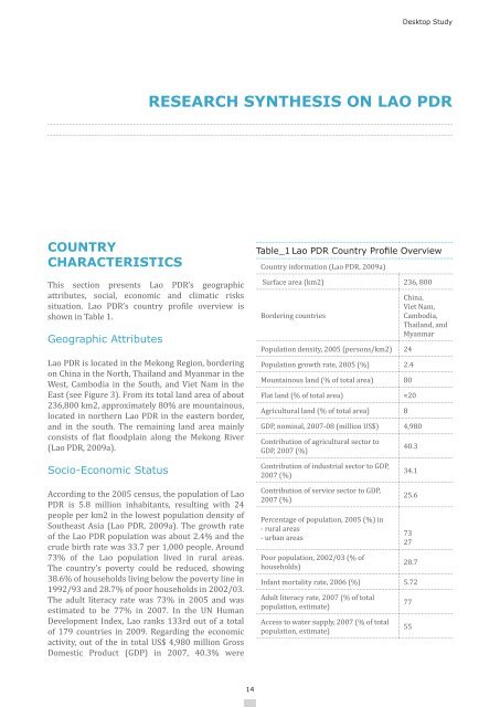
Table_1 Lao PDR Country Profile Overview<br />
Country informati<strong>on</strong> (Lao PDR, 2009a)<br />
Surface area (km2) 236, 800<br />
Bordering countries<br />
Populati<strong>on</strong> density, 2005 (pers<strong>on</strong>s/km2) 24<br />
Populati<strong>on</strong> growth rate, 2005 (%) 2.4<br />
Mountainous land (% of total area) 80<br />
Flat land (% of total area)<br />
Agricultural land (% of total area) 8<br />
China,<br />
Viet Nam,<br />
Cambodia,<br />
Thailand, and<br />
Myanmar<br />
≈20<br />
GDP, nominal, 2007-08 (milli<strong>on</strong> US$) 4,980<br />
C<strong>on</strong>tributi<strong>on</strong> of agricultural sector to<br />
GDP, 2007 (%)<br />
40.3<br />
Socio-Ec<strong>on</strong>omic Status<br />
C<strong>on</strong>tributi<strong>on</strong> of industrial sector to GDP,<br />
2007 (%)<br />
34.1<br />
According to the 2005 census, the populati<strong>on</strong> of Lao<br />
PDR is 5.8 milli<strong>on</strong> inhabitants, resulting with 24<br />
people per km2 in the lowest populati<strong>on</strong> density of<br />
Southeast Asia (Lao PDR, 2009a). The growth rate<br />
of the Lao PDR populati<strong>on</strong> was about 2.4% and the<br />
crude birth rate was 33.7 per 1,000 people. Around<br />
73% of the Lao populati<strong>on</strong> lived in rural areas.<br />
The country’s poverty could be reduced, showing<br />
38.6% of households living below the poverty line in<br />
1992/93 and 28.7% of poor households in 2002/03.<br />
The adult literacy rate was 73% in 2005 and was<br />
estimated to be 77% in 2007. In the UN Human<br />
Development Index, Lao ranks 133rd out of a total<br />
of 179 countries in 2009. Regarding the ec<strong>on</strong>omic<br />
activity, out of the in total US$ 4,980 milli<strong>on</strong> Gross<br />
Domestic Product (GDP) in 2007, 40.3% were<br />
C<strong>on</strong>tributi<strong>on</strong> of service sector to GDP,<br />
2007 (%)<br />
Percentage of populati<strong>on</strong>, 2005 (%) in<br />
- rural areas<br />
- urban areas<br />
Poor populati<strong>on</strong>, 2002/03 (% of<br />
households)<br />
25.6<br />
73<br />
27<br />
28.7<br />
Infant mortality rate, 2006 (%) 5.72<br />
Adult literacy rate, 2007 (% of total<br />
populati<strong>on</strong>, estimate)<br />
Access to water supply, 2007 (% of total<br />
populati<strong>on</strong>, estimate)<br />
77<br />
55<br />
14