east liberty station: realizing the potential - City of Pittsburgh
east liberty station: realizing the potential - City of Pittsburgh
east liberty station: realizing the potential - City of Pittsburgh

You also want an ePaper? Increase the reach of your titles
YUMPU automatically turns print PDFs into web optimized ePapers that Google loves.
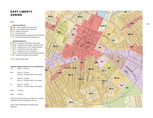
EAST LIBERTY<br />
ZONING<br />
Key<br />
Mixed Use Districts<br />
UNC - urban neighborhood commercial<br />
LNC - local neighborhood commercial<br />
HC - highway commercial<br />
UI - urban Industrial<br />
AP- residential/commercial planned unit development<br />
CP - commercial planned unit development<br />
45<br />
Residential Districts<br />
RM-H - residential multi-family, high density<br />
RM-M - residential multi-family, moderate density<br />
R3-M - residential three-unit, moderate density<br />
R2-H - residential two-unit, high density<br />
R2-L - residential two-unit, low density<br />
R1A-H - residential single-unit attached, high density<br />
RP - residential Planned unit development<br />
PO - parks and open space<br />
Allowable Height & Density for key classifications:<br />
LNC<br />
FAR 2.0 - 3 Stories<br />
FAR 2.0 - 3 Stories<br />
UNC<br />
FAR 3.0 - 3 Stories<br />
FAR 4.0 - 4 Stories (1500’ from <strong>station</strong>)<br />
HC<br />
FAR 2.0 - 5 Stories<br />
FAR 3.0 - 5 Stories (1500’ from <strong>station</strong>)<br />
UI<br />
FAR 3.0 - 4 Stories<br />
FAR 4.0 - 4 Stories (1500’ from <strong>station</strong>)<br />
RM-M<br />
4 Stories<br />
RM-H<br />
9 Stories<br />
Planned Unit district height and intensity is generally<br />
regulated by that <strong>of</strong> <strong>the</strong> adjacent districts.<br />
Source: <strong>City</strong> <strong>of</strong> <strong>Pittsburgh</strong> GIS & Zoning Code |<br />
Studio fSP