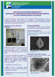
Monografija - Geološki zavod Slovenije
Monografija - Geološki zavod Slovenije
Monografija - Geološki zavod Slovenije

You also want an ePaper? Increase the reach of your titles
YUMPU automatically turns print PDFs into web optimized ePapers that Google loves.
Marko KomacNapoved verjetnosti pojavljanja plazov z analizo satelitskih in drugih prostorskih podatkov34 DeGraff, J. V. & Romesburg, H. C. 1984: Regional landslide susceptibility assessmentfor wildland managegment: a matrix approach.- In: Coates, D. R. & Vitak, J. (Eds.)Thresholds in geomorphology, Allen and Unwin, p. 401–414, Boston.35 Dhakal, A. S., Amada, T. & Aniya, M. 2000: Landslide hazard mapping and itsevaluation using GIS: An investigation of sampling schemes for a grid-cell basedquantitative method.- Photogrammetric engineering and remote sensing, Vol. 66(8),American Society of Photogrammetry and Remote Sensing, p. 981–989, Falls Church.36 Doornkamp, J. C. & King, C. A. M. 1971: Numerical analysis in geomorphology: anintroduction.- Arnold, 327 str., London.37 Eastman, J. R., Kyem, P. A. K., Toledano, J. 1993: A procedure for multi-objectivedecision making in GIS under conditions of conflicting objectives.- Proceedings of theFourth European Conference and Exhibition on Geographical Information SystemsEGIS '93, Vol. 1, EGIS Foundation, p. 438–447, Genova.38 Eastman, J. R., Jin., W., Kyem, P. A. K. & Toledano, J. 1995: Raster Procedures forMulti-Criteria and Multi-Objective Decisions.- Photogrammetric engineering andremote sensing, Vol. 61(5), American Society of Photogrammetry and RemoteSensing, p. 539–547, Falls Church.39 ERDAS, 1999: ERDAS Field Guide .- ERDAS, Inc., 698 str., Atlanta.40 ESRI, 1999: ARC/INFO, Version 8.0 – Help System.- Environmental SystemsResearch Institute, inc., Redlands.41 Fazarinc, R. & Pintar, J. 1991: Plazna erozija kot posledica intenzivnih padavin.-Gradbeni vestnik, let. 40, št. 1–2, Zveza društev gradbenih inženirjev in tehnikov<strong>Slovenije</strong>, str. 10–12, Ljubljana.42 Fell, R. 1994: Landslide risk assessment and acceptable risk.- Canadian GeotechnicalJournal, vol. 31, NRC Research Press, p. 261–272, Ottawa.43 Fortner, B. & Meyer, T. E. 1997: Number by colors: a guide to using color tounderstand technical data.- Springer–Verlag, str. 109, New York.44 Gee, M. D. 1992: Classification of hazard zonation methods and a test of predictivecapability.- In: Bell, D. H. (Ed.) Proceedings of 6 th International Symposium onLandslides, A. A. Balkema, p. 947–952, Christchurch.45 Gorsevski, P. V., Gessler, P. & Foltz, R. B. 2000a: Spatial prediction of Landslidehazard using discriminant analysis and GIS.- GIS in the Rockies 2000, Conferenceand Workshop, Denver.46 Gorsevski, P. V., Gessler, P. & Foltz, R. B. 2000b: Spatial prediction of Landslidehazard using logistic regression and GIS.- 4 th International Conference on IntegratingGIS and Environmental Modeling (GIS/EM4): Problems, Prospect and ResearchNeeds, Banff, Alberta.216 <strong>Geološki</strong> <strong>zavod</strong> <strong>Slovenije</strong>