Town of Summerville Planning Area - BCD Council of Governments
Town of Summerville Planning Area - BCD Council of Governments
Town of Summerville Planning Area - BCD Council of Governments
- No tags were found...

Create successful ePaper yourself
Turn your PDF publications into a flip-book with our unique Google optimized e-Paper software.
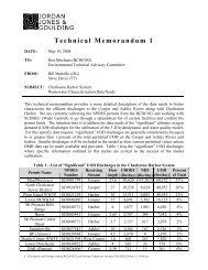
The Ladson Road/Trolley Road/Dorchester Road Intersection Commercial District should be planned forcontinued expansion <strong>of</strong> the commercial, residential and a mixture <strong>of</strong> retail, pr<strong>of</strong>essional <strong>of</strong>fice, recreation andinstitutional land uses. Plans are underway for a CARTA Express transit route in this area as identified on theTransit Service and Potential Commuter Rail‐Map #5.The east Ladson Road Commercial District located towards the intersection <strong>of</strong> Lincolnville Road is planned forcontinued commercial growth. Commercial land uses should remain predominate in this District.Traditional suburban style shopping centers and other commercial sites located in these Commercial Districtsshould be redeveloped considering the proximity to existing infrastructure and surrounding services. Highdensity residential and mixed use is recommended and should be planned in redevelopment projects. Shoppingcenters with large oversized parking lots should consider out‐parceling to facilitate redevelopment. Outparcelingis a lot separated from a commercial development which may be sold or developed.Gateway Mixed Use (GMU) DistrictThe Gateway Mixed Use District is intended to enhance the traditional street grid system within the <strong>Town</strong> <strong>of</strong><strong>Summerville</strong> and encourage a mixture <strong>of</strong> light and heavy commercial, retail, <strong>of</strong>fice and residential land uses.The GMU District comprises portions <strong>of</strong> “New <strong>Town</strong>” <strong>Summerville</strong> with a mixture <strong>of</strong> commercial and residentialland uses. The boundaries <strong>of</strong> the GMU District extend northward <strong>of</strong> the NSX Rail line along Main Street towardsthe Berlin G. Myers Parkway intersection <strong>of</strong> Main Street. The western boundary is along Pine Street, the easternboundary is approximately a quarter mile south <strong>of</strong> the Berlin G. Myers Parkway north <strong>of</strong> the NSX Rail line.The Berlin G. Myers Parkway, Fifth Street North (US 78) and Main Street (Highway 17A) are major transportationcorridors bisecting the GMU District. Transportation widening projects and new road construction is planned forportions <strong>of</strong> the GMU District. Fifth Street North is scheduled to be widened from a two lane to four lane road;while the Berlin G. Myers/Maple Street Extension is programmed in the CHATS Long Range Transportation Plan.The GMU District is located adjacent to the NSX rail line. A Commuter Rail Feasibility Study is currently beingundertaken by the <strong>BCD</strong>COG.Multiple land uses encouraging a variety <strong>of</strong> intensities to support transit and commuter rail will be encouragedwithin the GMU District through zoning regulations. High residential densities are recommended for the GMUDistrict. Potential commuter rail station sites have been identified on the Transit Service and PotentialCommuter Rail‐Map #5 and referenced in the Transportation Design Element and Priority Investment <strong>Area</strong>sElement.The GMU District contains the luxury <strong>of</strong> a highly connected street network, major transportation corridors andsupporting transit services. Vertical growth and compact land development will be planned for the GMUDistrict.Neighborhood Mixed Use (NMU) DistrictThe Neighborhood Mixed Use District is intended to encourage the integration <strong>of</strong> commercial and residentialland uses.The NMU District is proposed in three areas: 1) North <strong>of</strong> Main Street along the Fifth Street North corridor,spanning west along Richardson Avenue towards the Fifth Street North/Richardson Avenue intersection. Thisportion consists <strong>of</strong> mainly residential land uses with commercial and industrial land uses surrounding the FifthStreet North/Richardson Avenue intersection. 2) Surrounding Miles Jamison Road /Gahagan Road intersection,spanning towards the Berlin G. Myers Parkway. This segment consists <strong>of</strong> commercial and residential land uses.3) The Coastal Center tract located along Miles Jamison Road.Future Land Use Element Page 3