Town of Summerville Planning Area - BCD Council of Governments
Town of Summerville Planning Area - BCD Council of Governments
Town of Summerville Planning Area - BCD Council of Governments
- No tags were found...
Create successful ePaper yourself
Turn your PDF publications into a flip-book with our unique Google optimized e-Paper software.
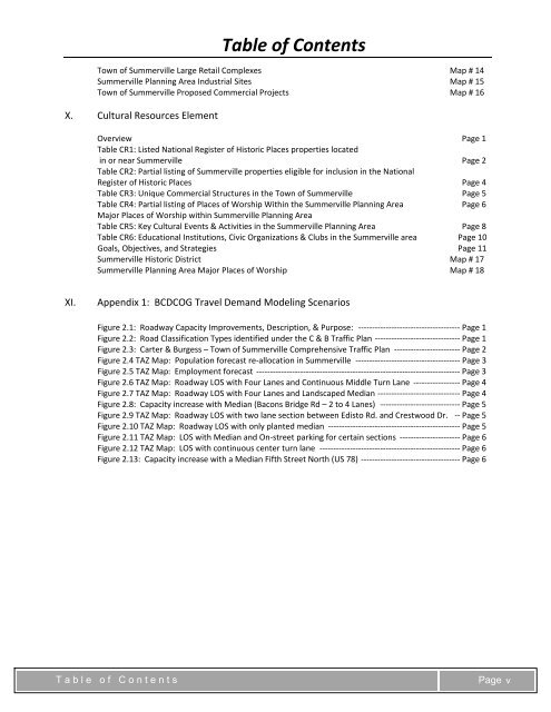
Table <strong>of</strong> Contents<strong>Town</strong> <strong>of</strong> <strong>Summerville</strong> Large Retail Complexes Map # 14<strong>Summerville</strong> <strong>Planning</strong> <strong>Area</strong> Industrial Sites Map # 15<strong>Town</strong> <strong>of</strong> <strong>Summerville</strong> Proposed Commercial Projects Map # 16X. Cultural Resources ElementOverview Page 1Table CR1: Listed National Register <strong>of</strong> Historic Places properties locatedin or near <strong>Summerville</strong> Page 2Table CR2: Partial listing <strong>of</strong> <strong>Summerville</strong> properties eligible for inclusion in the NationalRegister <strong>of</strong> Historic Places Page 4Table CR3: Unique Commercial Structures in the <strong>Town</strong> <strong>of</strong> <strong>Summerville</strong> Page 5Table CR4: Partial listing <strong>of</strong> Places <strong>of</strong> Worship Within the <strong>Summerville</strong> <strong>Planning</strong> <strong>Area</strong> Page 6Major Places <strong>of</strong> Worship within <strong>Summerville</strong> <strong>Planning</strong> <strong>Area</strong>Table CR5: Key Cultural Events & Activities in the <strong>Summerville</strong> <strong>Planning</strong> <strong>Area</strong> Page 8Table CR6: Educational Institutions, Civic Organizations & Clubs in the <strong>Summerville</strong> area Page 10Goals, Objectives, and Strategies Page 11<strong>Summerville</strong> Historic District Map # 17<strong>Summerville</strong> <strong>Planning</strong> <strong>Area</strong> Major Places <strong>of</strong> Worship Map # 18XI.Appendix 1: <strong>BCD</strong>COG Travel Demand Modeling ScenariosFigure 2.1: Roadway Capacity Improvements, Description, & Purpose: ‐‐‐‐‐‐‐‐‐‐‐‐‐‐‐‐‐‐‐‐‐‐‐‐‐‐‐‐‐‐‐‐‐‐‐‐‐ Page 1Figure 2.2: Road Classification Types identified under the C & B Traffic Plan ‐‐‐‐‐‐‐‐‐‐‐‐‐‐‐‐‐‐‐‐‐‐‐‐‐‐‐‐‐‐‐ Page 1Figure 2.3: Carter & Burgess – <strong>Town</strong> <strong>of</strong> <strong>Summerville</strong> Comprehensive Traffic Plan ‐‐‐‐‐‐‐‐‐‐‐‐‐‐‐‐‐‐‐‐‐‐‐‐ Page 2Figure 2.4 TAZ Map: Population forecast re‐allocation in <strong>Summerville</strong> ‐‐‐‐‐‐‐‐‐‐‐‐‐‐‐‐‐‐‐‐‐‐‐‐‐‐‐‐‐‐‐‐‐‐‐‐‐‐ Page 3Figure 2.5 TAZ Map: Employment forecast ‐‐‐‐‐‐‐‐‐‐‐‐‐‐‐‐‐‐‐‐‐‐‐‐‐‐‐‐‐‐‐‐‐‐‐‐‐‐‐‐‐‐‐‐‐‐‐‐‐‐‐‐‐‐‐‐‐‐‐‐‐‐‐‐‐‐‐‐‐‐‐‐‐‐ Page 3Figure 2.6 TAZ Map: Roadway LOS with Four Lanes and Continuous Middle Turn Lane ‐‐‐‐‐‐‐‐‐‐‐‐‐‐‐‐‐ Page 4Figure 2.7 TAZ Map: Roadway LOS with Four Lanes and Landscaped Median ‐‐‐‐‐‐‐‐‐‐‐‐‐‐‐‐‐‐‐‐‐‐‐‐‐‐‐‐‐‐ Page 4Figure 2.8: Capacity increase with Median (Bacons Bridge Rd – 2 to 4 Lanes) ‐‐‐‐‐‐‐‐‐‐‐‐‐‐‐‐‐‐‐‐‐‐‐‐‐‐‐‐‐ Page 5Figure 2.9 TAZ Map: Roadway LOS with two lane section between Edisto Rd. and Crestwood Dr. ‐‐ Page 5Figure 2.10 TAZ Map: Roadway LOS with only planted median ‐‐‐‐‐‐‐‐‐‐‐‐‐‐‐‐‐‐‐‐‐‐‐‐‐‐‐‐‐‐‐‐‐‐‐‐‐‐‐‐‐‐‐‐‐‐‐‐ Page 5Figure 2.11 TAZ Map: LOS with Median and On‐street parking for certain sections ‐‐‐‐‐‐‐‐‐‐‐‐‐‐‐‐‐‐‐‐‐‐ Page 6Figure 2.12 TAZ Map: LOS with continuous center turn lane ‐‐‐‐‐‐‐‐‐‐‐‐‐‐‐‐‐‐‐‐‐‐‐‐‐‐‐‐‐‐‐‐‐‐‐‐‐‐‐‐‐‐‐‐‐‐‐‐‐‐‐ Page 6Figure 2.13: Capacity increase with a Median Fifth Street North (US 78) ‐‐‐‐‐‐‐‐‐‐‐‐‐‐‐‐‐‐‐‐‐‐‐‐‐‐‐‐‐‐‐‐‐‐‐‐ Page 6Table <strong>of</strong> ContentsPage v


