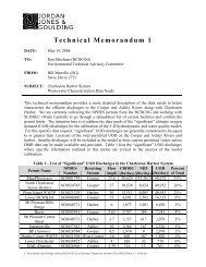
Town of Summerville Planning Area - BCD Council of Governments
Town of Summerville Planning Area - BCD Council of Governments
Town of Summerville Planning Area - BCD Council of Governments
- No tags were found...

Create successful ePaper yourself
Turn your PDF publications into a flip-book with our unique Google optimized e-Paper software.
The transportation network <strong>of</strong> new residential subdivisions should promote connectivity with existing residentialneighborhoods. These transportation connection points will disperse traffic, increase mobility and provide avariety <strong>of</strong> travel routes for vehicles and pedestrians, while limiting congestion on arterial roads. Morerecommendations for transportation connectivity and street network design are provided in the TransportationDesign Element.Rural Residential (RR) DistrictThe Rural Residential District is intended to promote and preserve low‐density residential neighborhoods withlimited infrastructure.The RR District is intended to encourage rural‐density residential neighborhoods with average densities <strong>of</strong> 1 unitper 5 to 8 acres. Environmental and culturally sensitive resources are prevalent in the RR District and should bepreserved. Future development will be designed to conserve environmentally sensitive resources and preserverural character. Residential land uses requiring limited public infrastructure are recommended for the RRDistrict.Public utilities, services and infrastructure capable <strong>of</strong> supporting large scale commercial, industrial or residentialdevelopment should be discouraged within the RR District.Rural Agricultural (RA) DistrictThe Rural Agricultural District is intended to preserve rural, agricultural and farm lands.The RA District encourages rural densities <strong>of</strong> 1 dwelling unit per 8 to 12 acres. The majority <strong>of</strong> the RA Districtconsists <strong>of</strong> large estate residential tracts with agricultural land uses. Natural and environmental resources areprevalent within the RA District.Large residential subdivisions are discouraged within the RA District. Future residential land uses shouldconserve rural character. <strong>Planning</strong> and land development techniques such as open space dedication,conservation subdivision design, low impervious surface coverage ratios, and preservation <strong>of</strong> roadside trees areencouraged to preserve the natural beauty and scenic landscape <strong>of</strong> the area.Sufficient buffering and setback requirements from cultural and natural resources will be encouraged. Limitedcurb cuts and alternative street design standards should be implemented to limit impervious surface coverage.Recreation Open SpaceThe Recreation Open Space designation classifies public and privately dedicated open space and passiverecreational land uses.Recreation Open Space District includes the Pine Forest and Miler Golf Course, the Sawmill Branch CanalPedestrian and Bicycle Trail, privately dedicated open space and easements in addition to the ColonialDorchester State Historic Site.The Recreation Open Space District designates passive recreational amenities and open space. Open space island that is essentially unimproved, set‐aside, and/or reserved and may be publicly or privately dedicated orowned. Passive recreational amenities are typically classified as walking trails, public parks, golf courses andother areas with limited structural improvements.The <strong>Town</strong> <strong>of</strong> <strong>Summerville</strong> will encourage the advancement <strong>of</strong> recreational efforts to provide a variety <strong>of</strong> activeand passive recreational conveniences for existing and future residents.Future Land Use Element Page 5