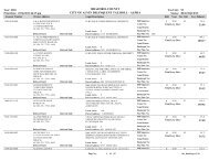
Comprehensive Master Plan - City of Alvin
Comprehensive Master Plan - City of Alvin
Comprehensive Master Plan - City of Alvin
- No tags were found...

Create successful ePaper yourself
Turn your PDF publications into a flip-book with our unique Google optimized e-Paper software.
Land Usefacts & figuresFuture <strong>Plan</strong>ning OutcomesThe committee worked in two smaller independent groups to developalternative growth and development scenarios. While they workedseparately, the outcomes were very similar as each defined uniqueboundaries to the downtown‐original town area and focused non‐residentialdevelopment along each <strong>of</strong> the major transportation corridors. The remainingareas were identified for residential development. Conclusions drawn fromthis exercise were as follows:• The participants recognize the uniqueness <strong>of</strong> the immediate downtownarea and the surrounding traditional neighborhoods. The designation <strong>of</strong>this area with unique boundaries acknowledges a need for handling thisarea different from recent development. To do so, the standards <strong>of</strong>development must be differentiated to preserve the unique characteristics<strong>of</strong> this area.• Each <strong>of</strong> the major transportation corridors were identified for nonresidentialuse. This rationale follows that which is now occurring and als<strong>of</strong>ollows the premise <strong>of</strong> higher land values adjacent to the highways as wellas increased provision for higher traffic volumes and truck access. One <strong>of</strong>the groups distinguished areas for commercial versus industrialdevelopment while the other simply designated them as universally nonresidential.In order to separate commercial and industrial uses, this wouldrequire either the use <strong>of</strong> some type <strong>of</strong> zoning or possible performancestandards related to building coverage, impervious area, floor area ratios,volume <strong>of</strong> truck and heavy vehicle traffic, number <strong>of</strong> loading bays, etc.Either way could accomplish similar objectives coupled with ordinanceprovisions for buffering between incompatible uses.• The areas outside <strong>of</strong> the downtown‐original town and the corridors weregenerally classified as residential without distinguishing between theindividual types <strong>of</strong> housing or their character. In other words, while therewas some indication according to the written survey that there is concernfor separating different types <strong>of</strong> residential uses, e.g. small versus largelots or site‐built versus manufactured homes, the future land userepresentations did not express this desire.• There was general acknowledgement for a more condense pattern <strong>of</strong>development as the focus was concentrated on the urbanized area <strong>of</strong> thecommunity. The outer periphery areas were generally perceived to be lessdense, large‐lot countryside areas. There were no determinations throughthis exercise as to limits <strong>of</strong> urban development or definition <strong>of</strong> urbanversus rural development.Page 3-41April 1, 2005