

Geoinformation for Disaster and Risk Management - ISPRS
Geoinformation for Disaster and Risk Management - ISPRS
Geoinformation for Disaster and Risk Management - ISPRS

You also want an ePaper? Increase the reach of your titles
YUMPU automatically turns print PDFs into web optimized ePapers that Google loves.
Check <strong>for</strong> compliance with risk regulation<br />
When the available Topographic L<strong>and</strong> Map <strong>and</strong> the<br />
housing data from the RAND were combined, it was<br />
possible to map all settlements within two<br />
kilometres of the coastline. A limited number of<br />
inspection sites were selected, where it was possible<br />
to collect field data including the use of a h<strong>and</strong>held<br />
Global Positioning System (GPS) to ensure positional<br />
accuracy. To be able to provide a benchmark,<br />
inspection sites were selected from various<br />
implementing agencies. To ascertain if newly<br />
constructed houses complied with government<br />
regulations, it is a straight<strong>for</strong>ward process to simply<br />
map the distance from the coast. As can be seen from<br />
Figure 4, some of the houses were constructed<br />
within 300 metres of the coastline. We can also see<br />
from this example that houses built by NGOs are<br />
located even closer to the coastline.<br />
Lessons learned<br />
From the housing audit in Aceh Indonesia, it is clear<br />
that many limitations exist concerning the<br />
availability of data. Data required <strong>for</strong> the audit do not<br />
exist or are not provided by the auditee. The<br />
combined use of GIS <strong>and</strong> remote sensing could help<br />
in resolving this problem. Data accuracy <strong>and</strong><br />
methods to assess the accuracy of spatial (audit)<br />
data still require more attention. As with all data<br />
used by an audit institute, reliability of the data used<br />
in the audit is important <strong>for</strong> its credibility <strong>and</strong> the<br />
confidence of the general public.<br />
86<br />
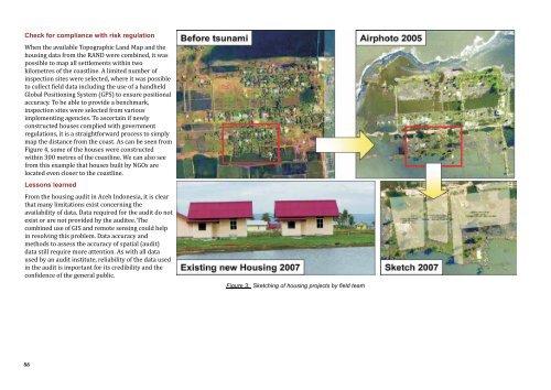
Figure 3: Sketching of housing projects by field team


