

Geoinformation for Disaster and Risk Management - ISPRS
Geoinformation for Disaster and Risk Management - ISPRS
Geoinformation for Disaster and Risk Management - ISPRS

Create successful ePaper yourself
Turn your PDF publications into a flip-book with our unique Google optimized e-Paper software.
Satellite communication serves to warn people at<br />
risk in remote areas, <strong>and</strong> to connect a disaster area<br />
to the outside world, providing medical in<strong>for</strong>mation<br />
(telemedicine) or geographic in<strong>for</strong>mation <strong>and</strong> data<br />
to support mapping activities. Global Navigation<br />
Satellite Systems (GNSS) provide positional<br />
in<strong>for</strong>mation on disaster related events <strong>and</strong> objects<br />
<strong>and</strong> support relief <strong>for</strong>ces in the field.<br />
Nevertheless, potential users worldwide are still<br />
facing questions about the existence, availability,<br />
accessibility, quality, costs, <strong>and</strong> timeliness of spacebased<br />
in<strong>for</strong>mation. There is clearly still a widespread<br />
need <strong>for</strong> an in<strong>for</strong>mation gateway to space-based<br />
in<strong>for</strong>mation <strong>for</strong> disaster management support.<br />
104<br />
Where mechanisms <strong>for</strong> providing earth observation<br />
data <strong>for</strong> disaster management are already available,<br />
their applications are restricted to supporting only<br />
response measures in the immediate aftermath of a<br />
disastrous event, not <strong>for</strong> covering pre-disaster<br />
activities such as mitigation <strong>and</strong> early warning, or<br />
monitoring of slow-onset disasters. An outst<strong>and</strong>ing<br />
example of these restrictions is given by the Terms of<br />
Reference of the International Charter Space <strong>and</strong><br />
Major <strong>Disaster</strong>s.<br />
http://www.disasterscharter.org/web/charter/charter<br />
What is UN-SPIDER ? M<strong>and</strong>ate <strong>and</strong> Mission<br />
The world of disaster management <strong>and</strong> space-based<br />
technologies is complex. Knowledge <strong>and</strong> expertise<br />
are widely dispersed. Institutions <strong>and</strong> practitioners<br />
need support, orientation <strong>and</strong> advice to access <strong>and</strong><br />
use available data, in<strong>for</strong>mation, knowledge <strong>and</strong><br />
services. In recognition of these needs the United<br />
Nations General Assembly, in its resolution<br />
A/RES/61/110 of 14 December 2006, established<br />
UN-SPIDER as a programme implemented by the<br />
United Nations Office <strong>for</strong> Outer Space Affairs<br />
(UNOOSA), with the following mission statement:<br />
“Ensure that all countries <strong>and</strong> international <strong>and</strong><br />
regional organizations have access to <strong>and</strong> develop<br />
the capacity to use all types of space-based<br />
in<strong>for</strong>mation to support the full disaster<br />
management cycle.”<br />
UN-SPIDER is a plat<strong>for</strong>m which advances the use of<br />
space-based technologies <strong>for</strong> disaster management<br />
<strong>and</strong> emergency response, by<br />
� being a gateway to space in<strong>for</strong>mation <strong>for</strong><br />
disaster management support;<br />
�serving as a bridge to connect the disaster<br />
management <strong>and</strong> space communities;<br />
�being a facilitator of capacity-building <strong>and</strong><br />
institutional strengthening.<br />
To fulfil these tasks, the UN-SPIDER core team relies<br />
on a global network of Regional Support Offices <strong>and</strong><br />
National Focal Points.<br />
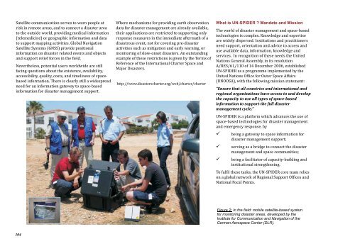
Figure 2: In the field: mobile satellite-based system<br />
<strong>for</strong> monitoring disaster areas, developed by the<br />
Institute <strong>for</strong> Communication <strong>and</strong> Navigation of the<br />
German Aerospace Center (DLR).


