

Geoinformation for Disaster and Risk Management - ISPRS
Geoinformation for Disaster and Risk Management - ISPRS
Geoinformation for Disaster and Risk Management - ISPRS

You also want an ePaper? Increase the reach of your titles
YUMPU automatically turns print PDFs into web optimized ePapers that Google loves.
The local capacity to use geoin<strong>for</strong>matics <strong>for</strong> LFEWS<br />
is gradually growing but still limited to a small<br />
number of institutions, such as universities <strong>and</strong> a<br />
few others. Substantial training is needed to enable<br />
more institutions to make full use of the potential of<br />
remote sensing <strong>and</strong> GIS tools. Cost remains a factor<br />
limiting the spreading of geoin<strong>for</strong>matics to many<br />
offices. However, the potential of free or low cost<br />
tools <strong>and</strong> data in flood risk management is<br />
substantial. There are several free <strong>and</strong> open-source<br />
(FOSS) GIS <strong>and</strong> remote sensing programs covering a<br />
wide range of tasks. Nevertheless, <strong>for</strong> specific<br />
processing tasks, such as <strong>for</strong> actual flood modeling<br />
or more advanced image processing, commercial<br />
software is still needed, <strong>and</strong> was also used in the<br />
setting up of the Binahaan LFEWS. Use was made of<br />
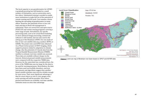
free or low-cost satellite data (e.g. L<strong>and</strong>sat, SRTM, or<br />
GDEM). The project also used SPOT data obtained<br />
via a Planet Action project of SPOT Imaging, which<br />
supports projects related to adaptation to climate<br />
change. Also the potential of 3-hourly data from the<br />
Tropical Rainfall Measurement Mission (TRMM)<br />
satellite to estimate real-time rainfall was assessed.<br />
These data are available without charge via the<br />
internet. Historical ground rainfall measurements<br />
were compared with the respective TRMM data.<br />
However, <strong>for</strong> the watershed size considered here, the<br />
error of the TRMM data was too large <strong>for</strong> the data to<br />
be used <strong>for</strong> warning purposes. Nevertheless, the data<br />
have been used successfully elsewhere, <strong>and</strong> new<br />
instruments <strong>and</strong> algorithms suggest that satellitebased<br />
rainfall estimates may soon be reliable enough<br />
<strong>for</strong> most areas. Their most significant advantage is<br />
that <strong>for</strong> areas where no rain or river gauges exist,<br />
early warning will still be possible. Even where<br />
ground instruments are available, real-time satellite<br />
estimates mean an extra time advantage<br />
Figure 4: L<strong>and</strong> use map of Binahaan river basin based on SPOT <strong>and</strong> ASTER data.<br />
61


