

Geoinformation for Disaster and Risk Management - ISPRS
Geoinformation for Disaster and Risk Management - ISPRS
Geoinformation for Disaster and Risk Management - ISPRS

Create successful ePaper yourself
Turn your PDF publications into a flip-book with our unique Google optimized e-Paper software.
Comm<strong>and</strong> <strong>and</strong> in<strong>for</strong>mation chain<br />
The central part of the LFEWS is a communication<br />
chain starting with reading <strong>and</strong> transmitting rainfall<br />
<strong>and</strong> river level data upstream to the OC. In case a<br />
threshold is exceeded a warning is issued by the OC<br />
<strong>and</strong> sent to the four municipalities. From there<br />
different villages are in<strong>for</strong>med, <strong>and</strong> the message is<br />
passed onto the households. Most steps of the chain<br />
use mobile <strong>and</strong> l<strong>and</strong>line phones, as well as radio<br />
communication. Households are often in<strong>for</strong>med with<br />
bells or megaphones, which is a simple but robust<br />
method.<br />
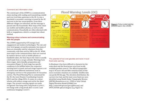
Warning colour scheme <strong>and</strong> communicating<br />
with the people<br />
The LFEWS supported by GTZ merges local<br />
engagement <strong>and</strong> modern technologies. The rain <strong>and</strong><br />
river level gauges are partly automatic, but many of<br />
them are manually read by volunteers from the<br />
community, with data sent by SMS to the OC. While<br />
most steps in the communication chain are covered<br />
by modern devices such as mobile phones or<br />
h<strong>and</strong>held radios, the final step in the chain is usually<br />
a bell made from a cut gas cylinder. Warnings have<br />
three stages: alert/st<strong>and</strong>by, preparation <strong>and</strong><br />
evacuation (Figure 3). Each stage has specific<br />
conditions to be fulfilled be<strong>for</strong>e the respective<br />
warning level is issued, <strong>and</strong> each stage requires a set<br />
of actions from different institutions such as<br />
emergency services or the preparation of evacuation<br />
centres. The Flood Warning Plan is customized <strong>for</strong><br />
the OC, the town <strong>Disaster</strong> Coordinating Councils<br />
(DCC) <strong>and</strong> the village DCCs. It comes in a colour<br />
scheme with yellow, orange <strong>and</strong> red <strong>for</strong> the three<br />
stages. The acoustic warning signals are easily<br />
recognised. One bang with a long break is Level 1,<br />
two bangs with a long break after is Level 2 <strong>and</strong><br />
continuous banging is Level 3.<br />
60<br />
The potential of low-cost geodata <strong>and</strong> tools in local<br />
flood early warning<br />
In Binahaan it has been difficult to characterize the<br />
watershed <strong>and</strong> the flood prone area from locally<br />
available geodata sources. The official topographic<br />
map is 50 years old <strong>and</strong> little statistical data on the<br />
socio-economic situation are available. Satellite data<br />
can partly fill this gap. The elevation distribution, the<br />
current river bed, <strong>and</strong> the l<strong>and</strong> cover/l<strong>and</strong> use were<br />
identified using Shuttle Radar Topography Mission<br />
[SRTM] (Kummerow et al., 1998) or Aster Global<br />
Digital Elevation Model [GDEM] (see<br />
http://asterweb.jpl.nasa.gov/gdem.asp), <strong>and</strong><br />
SPOT/ASTER optical imagery (e.g. Figure 4).<br />
Figure 3: Colour-coded alerting<br />
scheme used in the LFEWS.


