

Geoinformation for Disaster and Risk Management - ISPRS
Geoinformation for Disaster and Risk Management - ISPRS
Geoinformation for Disaster and Risk Management - ISPRS

Create successful ePaper yourself
Turn your PDF publications into a flip-book with our unique Google optimized e-Paper software.
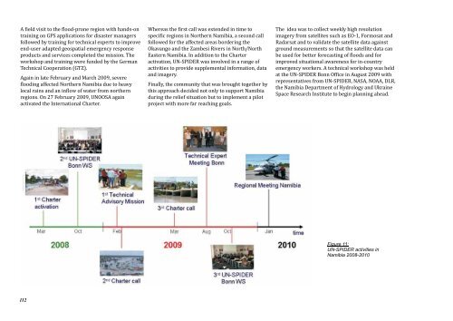
A field visit to the flood-prone region with h<strong>and</strong>s-on<br />
training on GPS applications <strong>for</strong> disaster managers<br />
followed by training <strong>for</strong> technical experts to improve<br />
end-user adapted geospatial emergency response<br />
products <strong>and</strong> services completed the mission. The<br />
workshop <strong>and</strong> training were funded by the German<br />
Technical Cooperation (GTZ).<br />
Again in late February <strong>and</strong> March 2009, severe<br />
flooding affected Northern Namibia due to heavy<br />
local rains <strong>and</strong> an inflow of water from northern<br />
regions. On 27 February 2009, UNOOSA again<br />
activated the International Charter.<br />
112<br />
Whereas the first call was extended in time to<br />
specific regions in Northern Namibia, a second call<br />
followed <strong>for</strong> the affected areas bordering the<br />
Okavango <strong>and</strong> the Zambesi Rivers in North/North<br />
Eastern Namibia. In addition to the Charter<br />
activation, UN-SPIDER was involved in a range of<br />
activities to provide supplemental in<strong>for</strong>mation, data<br />
<strong>and</strong> imagery.<br />
Finally, the community that was brought together by<br />
this approach decided not only to support Namibia<br />
during the relief situation but to implement a pilot<br />
project with more far reaching goals.<br />
The idea was to collect weekly high resolution<br />
imagery from satellites such as EO-1, Formosat <strong>and</strong><br />
Radarsat <strong>and</strong> to validate the satellite data against<br />
ground measurements so that the satellite data can<br />
be used <strong>for</strong> better <strong>for</strong>ecasting of floods <strong>and</strong> <strong>for</strong><br />
improved situational awareness <strong>for</strong> in-country<br />
emergency workers. A technical workshop was held<br />
at the UN-SPIDER Bonn Office in August 2009 with<br />
representatives from UN-SPIDER, NASA, NOAA, DLR,<br />
the Namibia Department of Hydrology <strong>and</strong> Ukraine<br />
Space Research Institute to begin planning ahead.<br />
Figure 11:<br />
UN-SPIDER activities in<br />
Namibia 2008-2010


