

Geoinformation for Disaster and Risk Management - ISPRS
Geoinformation for Disaster and Risk Management - ISPRS
Geoinformation for Disaster and Risk Management - ISPRS

You also want an ePaper? Increase the reach of your titles
YUMPU automatically turns print PDFs into web optimized ePapers that Google loves.
Conclusions<br />
A Web-GIS developed separately <strong>for</strong> the Earthquakes<br />
<strong>and</strong> Volcanoes plat<strong>for</strong>ms has been developed<br />
according to end-users requirements. The EO<br />
products relating to the selected eruption occurring<br />
at Mt. Etna (Sicily) in 2001 have been integrated with<br />
the geophysical in<strong>for</strong>mation derived from the ground<br />
network. The Web-GIS has been designed to supply<br />
specific in<strong>for</strong>mation in a user-friendly <strong>and</strong> efficient<br />
way <strong>and</strong> to support Civil Protection in the decision<br />
process.<br />
During the 2006 Mt. Etna eruption we per<strong>for</strong>med a<br />
successfully pre-operative test on the two phases. In<br />
the first phase, we tested the European Space Agency<br />
procedures to rapidly receive the EO data to obtain<br />
the ground surface de<strong>for</strong>mation. In the second phase<br />
characterized by paroxysmal events with volcanic<br />
ash emission, we tested the procedures to give<br />
relevant in<strong>for</strong>mation on volcanic ash to DPC to<br />
support their decision making process. This test<br />
does not address the precise location of events <strong>for</strong><br />
prevention <strong>and</strong> mitigation purposes, but responds to<br />
the needs of decision-makers to better underst<strong>and</strong><br />
the situation <strong>and</strong> to identify vulnerable populations.<br />
The Preview project work <strong>and</strong> the pre-operative test<br />
is an example of successful collaboration between<br />
industry <strong>and</strong> a national body using results from the<br />
scientific community in a practical way the <strong>for</strong> the<br />
risk management.<br />
The work carried out will be further developed to an<br />
operational stage through the new project SAFER<br />
funded by the European Union in the FP7<br />
framework.<br />
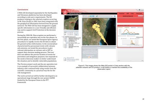
Figure 6: This image shows the Web-GIS portal in Crisis section with the<br />
selected volcanic ash EO product. In left bottom is marked the availability of the<br />
observation report.<br />
81


