

Geoinformation for Disaster and Risk Management - ISPRS
Geoinformation for Disaster and Risk Management - ISPRS
Geoinformation for Disaster and Risk Management - ISPRS

Create successful ePaper yourself
Turn your PDF publications into a flip-book with our unique Google optimized e-Paper software.
Case Study: Kinglake Complex Fire, Australia<br />
In February, 2009, multiple days of temperatures<br />
above 41ºC (106ºF) combined with low humidity, 13<br />
years of drought, <strong>and</strong> northerly 100 kilometres per<br />
hour winds to create an alignment of <strong>for</strong>ces that<br />
produced extreme bushfire conditions that far<br />
exceeded the maximum fire danger ever recorded.<br />
Melbourne, Australia recorded its hottest day ever, a<br />
blistering 46.6ºC (116ºF).<br />
Police in the state of Victoria were directed to search<br />
every property within the Kinglake Complex fire<br />
perimeter, 222,500 hectares with more than 8,000<br />
properties <strong>and</strong> structures.. The organization had<br />
never carried out such a large-scale emergency<br />
damage assessment.<br />
The traditional method <strong>for</strong> documenting property<br />
searches was manual. Victoria Police looked at their<br />
current assessment tools, paper maps, <strong>for</strong>ms, <strong>and</strong><br />
binders <strong>and</strong> realized they had a problem. There was<br />
no time <strong>for</strong> errors such as <strong>for</strong>ms being incomplete or<br />
inaccurate, requiring properties to be searched<br />
again. The need <strong>for</strong> accurate, speedy in<strong>for</strong>mation<br />
prompted the use of geospatial technologies <strong>and</strong><br />
real-time mobile GIS to determine the extent of the<br />
devastation <strong>and</strong> to document the location of human<br />
remains. For 43 days, emergency responders helped<br />
carry out search operations. More than 40 GIS<br />
personnel worked 3,600 total hours (306 work<br />
days).<br />
Each night staff members from the Rescue<br />
Coordination Centre drove the 150-kilometre roundtrip<br />
to the incident comm<strong>and</strong> post in Kinglake. They<br />
retrieved <strong>for</strong>ms <strong>and</strong> memory cards <strong>for</strong> cameras, then<br />
manually typed newly captured data from the paper<br />
96<br />
<strong>for</strong>ms into the database. The updated database was<br />
used to generate maps depicting areas searched <strong>and</strong><br />
areas needing to be searched. Search managers<br />
monitored field operations on a continuous basis<br />
with dynamic data constantly coming into comm<strong>and</strong><br />
centres <strong>and</strong> in turn updated in all mobile devices in<br />
the field.<br />
Staff found that the process when collecting<br />
in<strong>for</strong>mation during their massive search was<br />
simplified <strong>and</strong> made faster. Using mobile GIS,<br />
thous<strong>and</strong>s of properties were searched <strong>and</strong> records<br />
were created, managed <strong>and</strong> shared easily.<br />
The officers commented favourably on how much<br />
time the application saved them. These were some of<br />
the same team leaders who had previously used<br />
paper <strong>for</strong>ms <strong>and</strong> had limited or no prior GIS<br />
experience.<br />
Using Mobile GIS to per<strong>for</strong>m the search in less than<br />
three weeks meant a faster, more efficient response<br />
time <strong>and</strong> the ability <strong>for</strong> thous<strong>and</strong>s of homeowners to<br />
return to their properties quickly <strong>and</strong> rebuild their<br />
lives.<br />
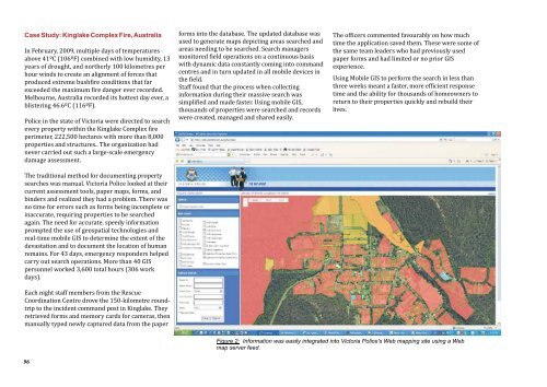
Figure 2: In<strong>for</strong>mation was easily integrated into Victoria Police's Web mapping site using a Web<br />
map server feed.


