

Geoinformation for Disaster and Risk Management - ISPRS
Geoinformation for Disaster and Risk Management - ISPRS
Geoinformation for Disaster and Risk Management - ISPRS

Create successful ePaper yourself
Turn your PDF publications into a flip-book with our unique Google optimized e-Paper software.
damage, together with major effects that are<br />
obscured from overhead viewing such as soft storey<br />
collapses. A detailed street-view perspective<br />
captured using tools like the VIEWS data collection<br />
system designed by ImageCat<br />
(www.imagecatinc.com ) in collaboration with<br />
MCEER (www.mceer.buffalo.edu), fills these<br />
in<strong>for</strong>mation gaps.<br />
VIEWS is a notebook-based field data collection <strong>and</strong><br />
visualization system. It integrates pre- <strong>and</strong> postdisaster<br />
remote sensing imagery with real-time GPS<br />
(Global Positioning System) readings <strong>and</strong> map layers,<br />
<strong>and</strong> operates in conjunction with a high-definition<br />
video (HDV) digital camera <strong>and</strong> digital video<br />
recorder. The VIEWS system was first deployed <strong>for</strong><br />
earthquake field reconnaissance following the<br />
December 2003 Bam (Iran) earthquake (Adams et<br />
al., 2004), <strong>and</strong> has since been utilised following<br />
events including the Indian Ocean tsunami <strong>and</strong> the<br />
2008 Wenchuan earthquake.<br />
Conclusion<br />
Within the risk management arena, to date, the<br />
research focus of remote sensing <strong>and</strong> GIS has<br />
generally been on engineering aspects of urban<br />
inventory. Nevertheless, faced with increasing<br />
human losses from natural disasters as urban<br />
populations exp<strong>and</strong>, the global research community<br />
is beginning to recognise the potential of these<br />
technologies <strong>for</strong> estimating socio-economic<br />
parameters.<br />
It can concluded that with the goal of minimising<br />
future human suffering <strong>and</strong> loss, in<strong>for</strong>mation on<br />
population <strong>and</strong> its distribution is one of the most<br />
crucial parameters <strong>for</strong> resilient disaster<br />
94<br />
<strong>Management</strong>. The case study of Ahmedabad<br />
demonstrates that population data <strong>for</strong> different<br />
spatial levels, as well as in<strong>for</strong>mation on the data<br />
source <strong>and</strong> associated metadata are scarce,<br />
expensive or unavailable. Initial results indicate that<br />
a tiered conceptual framework provides a<br />
transparent <strong>and</strong> consistent system <strong>for</strong> estimating<br />
population at different levels. Implementation of the<br />
framework described is currently being completed<br />
<strong>and</strong> initial results are expected in early 2010.<br />
Remote sensing <strong>and</strong> GIS are also increasingly being<br />
used <strong>for</strong> inventory data development <strong>and</strong> disaster<br />
response within the re/insurance <strong>and</strong> humanitarian<br />
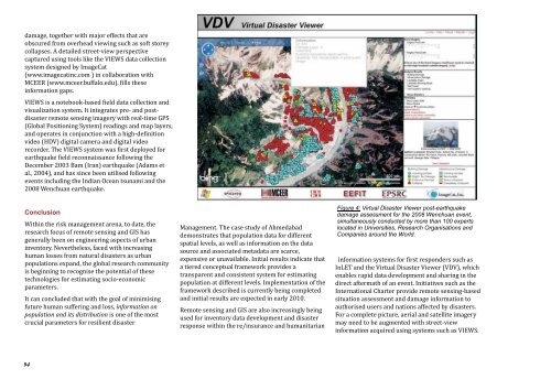
Figure 4: Virtual <strong>Disaster</strong> Viewer post-earthquake<br />
damage assessment <strong>for</strong> the 2008 Wenchuan event,<br />
simultaneously conducted by more than 100 experts<br />
located in Universities, Research Organisations <strong>and</strong><br />
Companies around the World.<br />
in<strong>for</strong>mation systems <strong>for</strong> first responders such as<br />
InLET <strong>and</strong> the Virtual <strong>Disaster</strong> Viewer (VDV), which<br />
enables rapid data development <strong>and</strong> sharing in the<br />
direct aftermath of an event. Initiatives such as the<br />
International Charter provide remote sensing-based<br />
situation assessment <strong>and</strong> damage in<strong>for</strong>mation to<br />
authorised users <strong>and</strong> nations affected by disasters.<br />
For a complete picture, aerial <strong>and</strong> satellite imagery<br />
may need to be augmented with street-view<br />
in<strong>for</strong>mation acquired using systems such as VIEWS.


