

Geoinformation for Disaster and Risk Management - ISPRS
Geoinformation for Disaster and Risk Management - ISPRS
Geoinformation for Disaster and Risk Management - ISPRS

Create successful ePaper yourself
Turn your PDF publications into a flip-book with our unique Google optimized e-Paper software.
22<br />
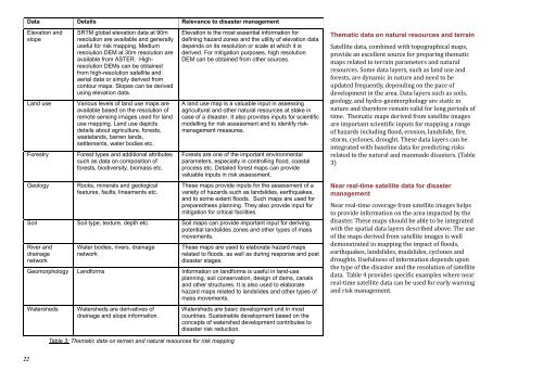
Data Details Relevance to disaster management<br />
Elevation <strong>and</strong><br />
slope<br />
SRTM global elevation data at 90m<br />
resolution are available <strong>and</strong> generally<br />
useful <strong>for</strong> risk mapping. Medium<br />
resolution DEM at 30m resolution are<br />
available from ASTER. Highresolution<br />
DEMs can be obtained<br />
from high-resolution satellite <strong>and</strong><br />
aerial data or simply derived from<br />
contour maps. Slopes can be derived<br />
using elevation data.<br />
L<strong>and</strong> use Various levels of l<strong>and</strong> use maps are<br />
available based on the resolution of<br />
remote sensing images used <strong>for</strong> l<strong>and</strong><br />
use mapping. L<strong>and</strong> use depicts<br />
details about agriculture, <strong>for</strong>ests,<br />
wastel<strong>and</strong>s, barren l<strong>and</strong>s,<br />
settlements, water bodies etc.<br />
Forestry Forest types <strong>and</strong> additional attributes<br />
such as data on composition of<br />
<strong>for</strong>ests, biodiversity, biomass etc.<br />
Geology Rocks, minerals <strong>and</strong> geological<br />
features, faults, lineaments etc.<br />
Elevation is the most essential in<strong>for</strong>mation <strong>for</strong><br />
defining hazard zones <strong>and</strong> the utility of elevation data<br />
depends on its resolution or scale at which it is<br />
derived. For mitigation purposes, high resolution<br />
DEM can be obtained from other sources.<br />
A l<strong>and</strong> use map is a valuable input in assessing<br />
agricultural <strong>and</strong> other natural resources at stake in<br />
case of a disaster. It also provides inputs <strong>for</strong> scientific<br />
modelling <strong>for</strong> risk assessment <strong>and</strong> to identify riskmanagement<br />
measures.<br />
Forests are one of the important environmental<br />
parameters, especially in controlling flood, coastal<br />
process etc. Detailed <strong>for</strong>est maps can provide<br />
valuable inputs in risk assessment.<br />
These maps provide inputs <strong>for</strong> the assessment of a<br />
variety of hazards such as l<strong>and</strong>slides, earthquakes,<br />
<strong>and</strong> to some extent floods. Such maps are used <strong>for</strong><br />
preparedness planning. They also provide input <strong>for</strong><br />
mitigation <strong>for</strong> critical facilities.<br />
Soil Soil type, texture, depth etc. Soil maps can provide important input <strong>for</strong> deriving<br />
potential l<strong>and</strong>slides zones <strong>and</strong> other types of mass<br />
movements.<br />
River <strong>and</strong><br />
drainage<br />
network<br />
Water bodies, rivers, drainage<br />
network<br />
These maps are used to elaborate hazard maps<br />
related to floods, as well as during response <strong>and</strong> post<br />
disaster stages.<br />
Geomorphology L<strong>and</strong><strong>for</strong>ms In<strong>for</strong>mation on l<strong>and</strong><strong>for</strong>ms is useful in l<strong>and</strong>-use<br />
planning, soil conservation, design of dams, canals<br />
<strong>and</strong> other structures. It is also used to elaborate<br />
hazard maps related to l<strong>and</strong>slides <strong>and</strong> other types of<br />
mass movements.<br />
Watersheds Watersheds are derivatives of<br />
drainage <strong>and</strong> slope in<strong>for</strong>mation.<br />
Table 3: Thematic data on terrain <strong>and</strong> natural resources <strong>for</strong> risk mapping<br />
Watersheds are basic development unit in most<br />
countries. Sustainable development based on the<br />
concepts of watershed development contributes to<br />
disaster risk reduction.<br />
Thematic data on natural resources <strong>and</strong> terrain<br />
Satellite data, combined with topographical maps,<br />
provide an excellent source <strong>for</strong> preparing thematic<br />
maps related to terrain parameters <strong>and</strong> natural<br />
resources. Some data layers, such as l<strong>and</strong> use <strong>and</strong><br />
<strong>for</strong>ests, are dynamic in nature <strong>and</strong> need to be<br />
updated frequently, depending on the pace of<br />
development in the area. Data layers such as soils,<br />
geology, <strong>and</strong> hydro-geomorphology are static in<br />
nature <strong>and</strong> there<strong>for</strong>e remain valid <strong>for</strong> long periods of<br />
time. Thematic maps derived from satellite images<br />
are important scientific inputs <strong>for</strong> mapping a range<br />
of hazards including flood, erosion, l<strong>and</strong>slide, fire,<br />
storm, cyclones, drought. These data layers can be<br />
integrated with baseline data <strong>for</strong> predicting risks<br />
related to the natural <strong>and</strong> manmade disasters. (Table<br />
3)<br />
Near real-time satellite data <strong>for</strong> disaster<br />
management<br />
Near real-time coverage from satellite images helps<br />
to provide in<strong>for</strong>mation on the area impacted by the<br />
disaster. These maps should be able to be integrated<br />
with the spatial data layers described above. The use<br />
of the maps derived from satellite images is well<br />
demonstrated in mapping the impact of floods,<br />
earthquakes, l<strong>and</strong>slides, mudslides, cyclones <strong>and</strong><br />
droughts. Usefulness of in<strong>for</strong>mation depends upon<br />
the type of the disaster <strong>and</strong> the resolution of satellite<br />
data. Table 4 provides specific examples where near<br />
real-time satellite data can be used <strong>for</strong> early warning<br />
<strong>and</strong> risk management.


