

Geoinformation for Disaster and Risk Management - ISPRS
Geoinformation for Disaster and Risk Management - ISPRS
Geoinformation for Disaster and Risk Management - ISPRS

Create successful ePaper yourself
Turn your PDF publications into a flip-book with our unique Google optimized e-Paper software.
Available remotely sensed data<br />
Timely triggering <strong>and</strong> absence of cloud cover<br />
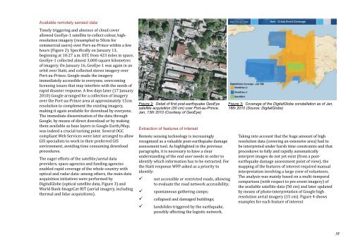
allowed GeoEye-1 satellite to collect colour, highresolution<br />
imagery (resampled to 50cm <strong>for</strong><br />
commercial users) over Port-au-Prince within a few<br />
hours (Figure 2). Specifically on January 13,<br />
beginning at 10:27 a.m. EST, from 423 miles in space,<br />
GeoEye-1 collected almost 3,000 square kilometres<br />
of imagery. On January 16, GeoEye-1 was again in an<br />
orbit over Haiti, <strong>and</strong> collected stereo imagery over<br />
Port-au-Prince. Google made the imagery<br />
immediately accessible to everyone, overcoming<br />
licensing issues that may interfere with the needs of<br />
rapid disaster response. A few days later (17 January<br />
2010) Google arranged <strong>for</strong> a collection of imagery<br />
over the Port-au-Prince area at approximately 15cm<br />
resolution to complement the existing imagery,<br />
making it again available <strong>for</strong> download by everyone.<br />
The immediate dissemination of the data through<br />
Google, by means of direct download or by making<br />
them available as base layers in Google Earth/Map,<br />
was indeed a crucial turning point. Several OGC<br />
compliant Web Services were later arranged to allow<br />
GIS specialists to work in their preferred GIS<br />
environment, avoiding time consuming download<br />
procedures.<br />
The eager ef<strong>for</strong>ts of the satellite/aerial data<br />
providers, space agencies <strong>and</strong> funding agencies<br />
enabled rapid coverage of the whole country with<br />
optical <strong>and</strong> radar data: among others, the main data<br />
acquisition initiatives were per<strong>for</strong>med by<br />
DigitalGlobe (optical satellite data, Figure 3) <strong>and</strong><br />
World Bank-ImageCat-RIT (aerial imagery, including<br />
thermal <strong>and</strong> lidar acquisitions).<br />
Figure 2: Detail of first post-earthquake GeoEye<br />
satellite acquisition (50 cm) over Port-au-Prince.<br />
Jan, 13th 2010 (Courtesy of GeoEye)<br />
Extraction of features of interest<br />
Remote sensing technology is increasingly<br />
recognized as a valuable post-earthquake damage<br />
assessment tool. As highlighted in the previous<br />
paragraphs, it is necessary to have a clear<br />
underst<strong>and</strong>ing of the end user needs in order to<br />
identify which in<strong>for</strong>mation has to be extracted. For<br />
the Haiti response WFP asked as a priority to<br />
identify:<br />
�not accessible or restricted roads, allowing<br />
to evaluate the road network accessibility;<br />
�spontaneous gathering camps;<br />
�collapsed <strong>and</strong> damaged buildings;<br />
�l<strong>and</strong>slides triggered by the earthquake,<br />
possibly affecting the logistic network.<br />
Figure 3: Coverage of the DigitalGlobe constellation as of Jan,<br />
18th 2010 (Source: DigitalGlobe)<br />
Taking into account that the huge amount of high<br />
resolution data (covering an extensive area) had to<br />
be interpreted under harsh time constraints <strong>and</strong> that<br />
procedures to fully <strong>and</strong> rapidly automatically<br />
interpret images do not yet exist (from a postearthquake<br />
damage assessment point of view), the<br />
mapping of the features of interest required manual<br />
interpretation involving a large crew of volunteers.<br />
The analysis was mainly based on a multi-temporal<br />
comparison (with respect to pre-event imagery) of<br />
the available satellite data (50 cm) <strong>and</strong> later updated<br />
by means of photo-interpretation of Google high<br />
resolution aerial imagery (15 cm). Figure 4 shows<br />
examples <strong>for</strong> each feature of interest<br />
33


