

Geoinformation for Disaster and Risk Management - ISPRS
Geoinformation for Disaster and Risk Management - ISPRS
Geoinformation for Disaster and Risk Management - ISPRS

Create successful ePaper yourself
Turn your PDF publications into a flip-book with our unique Google optimized e-Paper software.
Three ingredients <strong>for</strong> success<br />
Multi-hazard approach<br />
GDACS was born out of a need to reduce the need to<br />
monitor several web sites <strong>for</strong> several disaster types.<br />
The European Commission Office <strong>for</strong> Humanitarian<br />
Aid (ECHO), one of the largest donors of<br />
humanitarian aid, expressed the wish <strong>for</strong> a single<br />
portal to access in<strong>for</strong>mation on any natural disaster.<br />
This has driven the early development of GDACS, or<br />
global disaster alert system. Only later was the<br />
system integrated with an in<strong>for</strong>mation system <strong>for</strong><br />
“coordination” response, which proved successful<br />
<strong>and</strong> will be described later.<br />
GDACS provides global multi-hazard disaster<br />
monitoring <strong>and</strong> alerting <strong>for</strong> earthquakes, tsunamis,<br />
floods, volcanoes <strong>and</strong> tropical cyclones. These<br />
hazards have very different physics <strong>and</strong> are studied<br />
in disconnected scientific communities. Through<br />
partnerships with scientific organisations <strong>and</strong> other<br />
hazard monitoring institutions, GDACS collects near<br />
real-time hazard in<strong>for</strong>mation, which is combined in<br />
GIS models with demographic <strong>and</strong> socio-economic<br />
data. GDACS per<strong>for</strong>ms a consequence analysis with a<br />
risk <strong>for</strong>mula combining the magnitude of a hazard<br />
with an element at risk (such as the amount of<br />
people in the affected area) <strong>and</strong> a vulnerability factor<br />
accounting <strong>for</strong> physical <strong>and</strong> socio-economic<br />
resilience of the affected area. For tsunamis, GDACS<br />
uses a novel tsunami system developed at the Joint<br />
Research Centre, which through 135000 precalculated<br />
scenarios, can provide an immediate<br />
assessment of tsunami risk .<br />
A system of systems based on open st<strong>and</strong>ards<br />
As research in early warning <strong>and</strong> alert systems is<br />
developing rapidly, existing data <strong>and</strong> models will<br />
soon be outdated. In order to provide a robust<br />
framework <strong>for</strong> cooperation, GDACS was designed<br />
from the beginning as a system of systems.<br />
Individual components can be exchanged with<br />
newer, better components that provide more added<br />
value <strong>for</strong> emergency responders.<br />
As a means to achieve interoperability of models <strong>and</strong><br />
systems, GDACS has promoted the use of st<strong>and</strong>ards<br />
<strong>for</strong> in<strong>for</strong>mation <strong>and</strong> communication. The two most<br />
important st<strong>and</strong>ards in the GDACS framework are<br />
RSS (a communication st<strong>and</strong>ard) <strong>and</strong> the GLIDE<br />
number (a content st<strong>and</strong>ard).<br />
The first, Really Simple Syndication or RSS, is a wellestablished<br />
XML <strong>for</strong>mat <strong>for</strong> exchange of messages.<br />
Because it is so simple <strong>and</strong> widely used, almost any<br />
organisation has the ability to produce RSS feeds,<br />
making it a very useful st<strong>and</strong>ard. Over the past few<br />
years, JRC has assisted several organisations to start<br />
producing RSS feeds, making their in<strong>for</strong>mation<br />
interoperable with GDACS.<br />
The second st<strong>and</strong>ard, the GLobal IDEntifier <strong>for</strong><br />
1<br />
disasters or GLIDE , is a unique identifier <strong>for</strong> a<br />
disaster, pioneered by the Asian <strong>Disaster</strong> Reduction<br />
Center. Its purpose is to allow many organisations to<br />
link their databases on disasters. This is not a trivial<br />
problem, because a disaster is a loosely defined<br />
concept used in different ways in different research<br />
<strong>and</strong> practitioner communities. The components of a<br />
GLIDE number consist of two letters to identify the<br />
disaster type (e.g. EQ - earthquake); the year of the<br />
disaster; a six-digit, sequential disaster number; <strong>and</strong><br />
the three-letter ISO code <strong>for</strong> country of occurrence.<br />
1 : http://www.glidenumber.net/<br />
Current scientific partners:<br />
�Earthquakes: US, Italian, European,<br />
German, Chinese <strong>and</strong> Russian<br />
seismological institutes<br />
�Tropical cyclones: Pacific <strong>Disaster</strong><br />
Centre<br />
�Floods: Dartmouth Flood Observatory,<br />
NASA, Ithaca<br />
�Volcanic eruptions: Smithsonian Global<br />
Volcanism Program<br />
�Tsunamis: NOAA, UNESCO<br />
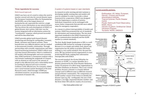
Physical observations<br />
GDACS collects<br />
in<strong>for</strong>mation from existing<br />
observation <strong>and</strong> early<br />
warning systems such<br />
as tsunami detection<br />
systems<br />
Global <strong>Disaster</strong> Alert<br />
<strong>and</strong> Coordination<br />
System (GDACS)<br />
GDACS adds value by<br />
assessing affected<br />
population density <strong>and</strong><br />
vulnerability. If the<br />
situation is severe,<br />
alerts are sent by SMS,<br />
fax <strong>and</strong> email.<br />
Discussion<br />
tools<br />
<strong>Disaster</strong> management<br />
community<br />
GDACS offers tools <strong>for</strong><br />
donors, search <strong>and</strong><br />
rescue <strong>and</strong> relief NGOs<br />
to coordinate response<br />
better<br />
News services<br />
Map services<br />
Web scraping<br />
GIS analysis<br />
Severity<br />
determination<br />
Figure 3. Principle of GDACS system<br />
Population density<br />
Vulnerability<br />
Critical<br />
infrastructure<br />
Alert<br />
(SMS, fax, email)<br />
3


