
Create successful ePaper yourself
Turn your PDF publications into a flip-book with our unique Google optimized e-Paper software.
spawning season. The fertilized eggs are<br />
suspended in water mass. The newly hatching<br />
larval have approximately 6.6 mm. in total<br />
length (TL), before developed from pre-flexion<br />
to flexion, post-flexion and juvenile stage,<br />
respectively. Thai river sprat is nocturnal fish,<br />
feeding on zooplankton (Whitehead, 1985 and<br />
Termvidchakorn, 2003).<br />
Distribution of Thai river sprat occurrs<br />
in the river and reservoir of Mekong basin in Laos,<br />
Cambodia and Thailand. In Thailand, Thai river<br />
sprats are distributed and abundant in the northeastern<br />
part. There were distribution records in<br />
Ubonratana (Khon Kaen province), Sirinthorn<br />
(Ubon Ratchathani province), Lompow (Kalasin<br />
province) and Pasak Jolasid reservoir (Lop Buri<br />
province) (Chookajorn et al., 1977 and Jutagate<br />
and De Silva, 2003).<br />
The aims of this paper were to study<br />
distribution and developing stages of Thai river<br />
sprat larvae in Pasak Jolasid reservoir. The fieldcollection<br />
materials and provided information<br />
were used on size and occurrence of larvae<br />
collected in sampling stations covering the whole<br />
reservoir by griding, that was able to understand<br />
early-life histories and some environmental<br />
conditions that required spawning and nursery.<br />
Finally, the outputs of this paper were be able to<br />
support Thai river sprat fishery management in<br />
Pasak Jolasid and others reservoir based on<br />
spawning-nursery ground and timing information.<br />
MATERIALS AND METHODS<br />
1. Study sites<br />
Pasak Jolasid reservoir is located in<br />
Pasak river at geological coordinated 14°50′ 32″<br />
N 101°05′ 00″E. The dam has been operational<br />
since September 1999 with 960 cubic million<br />
meter at maximum level, 43 meters above the<br />
mean sea level, covering approximately 149 square<br />
kilometers. The dam receives most water from<br />
Pasak river, originating from Phetchabun mountain<br />
Kasetsart J. (Nat. Sci.) 40(1) 189<br />
in the South of Loei province.<br />
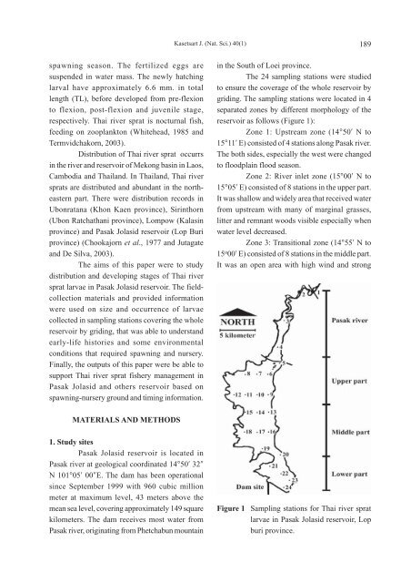
The 24 sampling stations were studied<br />
to ensure the coverage of the whole reservoir by<br />
griding. The sampling stations were located in 4<br />
separated zones by different morphology of the<br />
reservoir as follows (Figure 1):<br />
Zone 1: Upstream zone (14°50′ N to<br />
15°11′ E) consisted of 4 stations along Pasak river.<br />
The both sides, especially the west were changed<br />
to floodplain flood season.<br />
Zone 2: River inlet zone (15°00′ N to<br />
15°05′ E) consisted of 8 stations in the upper part.<br />
It was shallow and widely area that received water<br />
from upstream with many of marginal grasses,<br />
litter and remnant woods visible especially when<br />
water level decreased.<br />
Zone 3: Transitional zone (14°55′ N to<br />
15 o 00′ E) consisted of 8 stations in the middle part.<br />
It was an open area with high wind and strong<br />
Figure 1 Sampling stations for Thai river sprat<br />
larvae in Pasak Jolasid reservoir, Lop<br />
buri province.