You also want an ePaper? Increase the reach of your titles
YUMPU automatically turns print PDFs into web optimized ePapers that Google loves.
interface, has been capably counseled maxima to<br />
five hundred drainage basins calibration. Adequate<br />
hydro-meteorology continuance investigation<br />
might insinuate reliable correlation coefficient<br />
while SWAT model provided contingent<br />
spontaneous precipitation (Srinivasan et al., 1995;<br />
Rosenthal et al.,1995; Srinivasan et al., 1996).<br />
Thus model was physically based requiring<br />
specific inputs for weather, soil, topography,<br />
vegetation, land management practice and<br />
watershed, which would be essential partitioned<br />
into hydrologic response units (HRU). These HRU<br />
(sub-watershed or sub-basins) severely based on<br />
land uses, soil types, channels, ponds or reservoirs.<br />
Hydrology simulation was separated into land<br />
phase and stream phase, while land phase<br />
controlled main channel transportation on water,<br />
sediment and agricultural chemicals but stream<br />
phase would be transported through channel grids<br />
into basin outlet (Sloto and Crouse, 1996; Steven,<br />
1998). Flood hydrograph and base flow analysis<br />
employed hydrologic respond unit together with<br />
stream flow hydrograph separation and analysis<br />
program (HySeP) (Vathananukij and<br />
Thanasiriyakul, 2002). Hydrological sub basin was<br />
basically on the following formulae.<br />
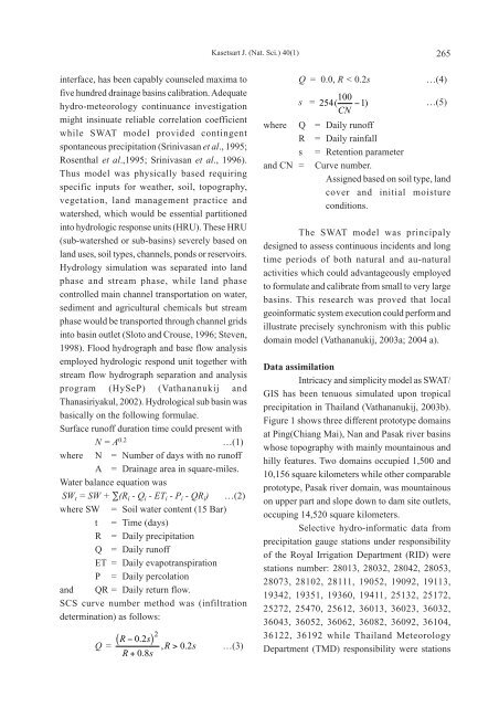
Surface runoff duration time could present with<br />
N = A 0.2 …(1)<br />
where N = Number of days with no runoff<br />
A = Drainage area in square-miles.<br />
Water balance equation was<br />
SW t = SW + ∑(R i - Q i - ET i - P i - QR i) …(2)<br />
where SW = Soil water content (15 Bar)<br />
t = Time (days)<br />
R = Daily precipitation<br />
Q = Daily runoff<br />
ET = Daily evapotranspiration<br />
P = Daily percolation<br />
and QR = Daily return flow.<br />
SCS curve number method was (infiltration<br />
determination) as follows:<br />
Q =<br />
( )<br />
R−02 . s<br />
R+ 08 . s<br />
2<br />
, R> 02 . s …(3)<br />
Kasetsart J. (Nat. Sci.) 40(1) 265<br />
Q=0.0, R < 0.2s …(4)<br />
s = 254 100 ( −1) CN<br />
…(5)<br />
where Q = Daily runoff<br />
R = Daily rainfall<br />
s = Retention parameter<br />
and CN = Curve number.<br />
Assigned based on soil type, land<br />
cover and initial moisture<br />
conditions.<br />
The SWAT model was principaly<br />
designed to assess continuous incidents and long<br />
time periods of both <strong>natural</strong> and au-<strong>natural</strong><br />
activities which could advantageously employed<br />
to formulate and calibrate from small to very large<br />
basins. This research was proved that local<br />
geoinformatic system execution could perform and<br />
illustrate precisely synchronism with this public<br />
domain model (Vathananukij, 2003a; 2004 a).<br />
Data assimilation<br />
Intricacy and simplicity model as SWAT/<br />
GIS has been tenuous simulated upon tropical<br />
precipitation in Thailand (Vathananukij, 2003b).<br />
Figure 1 shows three different prototype domains<br />
at Ping(Chiang Mai), Nan and Pasak river basins<br />
whose topography with mainly mountainous and<br />
hilly features. Two domains occupied 1,500 and<br />
10,156 square kilometers while other comparable<br />
prototype, Pasak river domain, was mountainous<br />
on upper part and slope down to dam site outlets,<br />
occuping 14,520 square kilometers.<br />
Selective hydro-informatic data from<br />
precipitation gauge stations under responsibility<br />
of the Royal Irrigation Department (RID) were<br />
stations number: 28013, 28032, 28042, 28053,<br />
28073, 28102, 28111, 19052, 19092, 19113,<br />
19342, 19351, 19360, 19411, 25132, 25172,<br />
25272, 25470, 25612, 36013, 36023, 36032,<br />
36043, 36052, 36062, 36082, 36092, 36104,<br />
36122, 36192 while Thailand Meteorology<br />
Department (TMD) responsibility were stations


