
You also want an ePaper? Increase the reach of your titles
YUMPU automatically turns print PDFs into web optimized ePapers that Google loves.
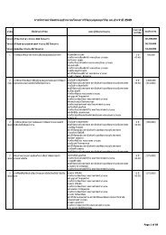
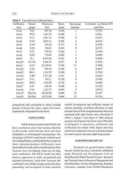
270<br />
Kasetsart J. (Nat. Sci.) 40(1)<br />
Table 3 Correlation on calibrated basin.<br />
Calibration Stream Basin area Basin Rain gauge Correlation coefficient (R 2 )<br />
area gauge Km 2 slope intensity total flow<br />
Area1 P.64 487.18 0.266 1 0.5795<br />
Area2 PN.8 1,567.67 0.299 1 0.5361<br />
Area3 N.17 1,091.15 0.306 0 0.3512<br />
Area4 N.42 2,047.11 0.296 2 0.6219<br />
Area5 N.49 153.16 0.317 0 0.4784<br />
Area6 N.50 194.61 0.324 0 0.4775<br />
Area7 N.51 758.53 0.240 1 0.5284<br />
Area8 N.63 776.05 0.202 1 0.4099<br />
Area9 N.1 4,495.06 0.241 8 0.6008<br />
Area10 N.13A 8,566.91 0.237 8 0.7045<br />
Area11 N.35 10,156.01 0.230 11 0.7008<br />
Area12 S.10 300.79 0.100 0 0.6037<br />
Area13 SM.1 1,132.70 0.248 2 0.7585<br />
Area14 S.4B 3,321.00 0.181 3 0.8285<br />
Area15 S.12 476.11 0.230 0 0.5450<br />
Area16 SM.2 7,329.49 0.158 6 0.8089<br />
Area17 S.13 395.25 0.100 0 0.7182<br />
Area18 S.14 1,252.77 0.087 0 0.8572<br />
Area19 S9.(Un) 14,323.80 0.068 13 0.7397<br />
Area20 S9.(Re) 14,323.80 0.068 13 0.9708<br />
comparison and correlation at outlet verified<br />
features (Chiang Mai basin, upper Nan basin,<br />
regulated & unregulated Pasak basin).<br />
CONCLUSON<br />
Public domain system model SWAT, has<br />
been executed on most water resource freeware<br />
in this decade, which become more and more<br />
standardize to technological contemporary. The<br />
advantages of SWAT model basely calibrate up to<br />
five hundred basins, could perform best results on<br />
these selected domains. Differences were<br />
permissible for both surface runoff and base flow<br />
fractions since investigated values are on large<br />
scale verification. The SWAT model has been<br />
elective appraised on both unregulated and<br />
regulated prototypes, which their issuances had<br />
confirmative best allied on large scale-mild slope<br />
potentiality and un-implied in both continual<br />
rainfall investigation and sufficient number of<br />
stations. Bondage correlation efficiency in large<br />
tropical basin of both unregulated steep slope and<br />
regulated mild slope basins were illustrated in<br />
Table 2, Figure 7 and Figure 8. Data analysis<br />
program development has been much efficiently<br />
investigated to operation, calibration and<br />
verification the model while digital elevation<br />
model was combined to become essential assistant<br />
on water resource decision supporting system.<br />
ACKNOWLEDGMENTS<br />
Research on geoinformatic public<br />
domain models has been consistently subsidized<br />
under Research and Development Unit on<br />
Geoinformatic Public Domain System / Research<br />
and Training Center on Resource Management and<br />
Geoinformatics, Faculty of Engineering, Kasetsart<br />
University. Together with GAME-Chaophraya