Anatolian Civilizations and Historical Sites - TEDA
Anatolian Civilizations and Historical Sites - TEDA
Anatolian Civilizations and Historical Sites - TEDA

Create successful ePaper yourself
Turn your PDF publications into a flip-book with our unique Google optimized e-Paper software.
ANATOLIAN CIVILIZATIONS:10x19 antik kentler 8/1/11 10:51 AM Sayfa<br />
180<br />
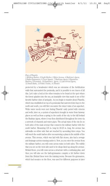
Plan of Phaselis<br />
1.Military Harbor, 2.South Harbor, 3.Main Avenue, 4.Hadrian’s Agora,<br />
5.Baths-Gymnasion, 6.Town Square, 7.Hadrians Agora, 8.Byzantine<br />
Basilica, 9.Fountain, 10.Domitian’s Agora, 11.Late-Period Agora,<br />
12.Small Baths, 13.Public Toilets, 14.Theater.<br />
protected by a breakwater which was an extension of the fortification<br />
walls that surrounded the peninsula, <strong>and</strong> it is possible to see traces of all<br />
this. Let’s take a look at the other remains to be found at the spot where<br />
the forest splashes into the sea, an insatiable view that made it one of the<br />
favorite harbor cities of antiquity. As you begin to w<strong>and</strong>er about Phaselis,<br />
which was established on top of a peninsula that narrowed into bays to the<br />
north <strong>and</strong> south, you will first encounter the intact ruins of an aqueduct.<br />
While water needs were met during Phaselis’ early period with cisterns<br />
<strong>and</strong> wells, later on, a system of aqueducts brought in water from faraway<br />
places as well as from a spring to the north of the city to the hill behind<br />
the Hadrian Agora, where it was then distributed throughout the town via<br />
a network of channels <strong>and</strong> water pipes. The actual ruins of the city lie on<br />
both sides of the main avenue that connects the military harbor with the<br />
south harbor. Measuring 125 m. long by 20-25 m. long, the avenue has<br />
sidewalks on either side that are reached by ascending three steps. You<br />
will reach the south harbor after encountering a plaza in the middle of the<br />
avenue. This avenue, which was laid with flat stones, also had a sewage<br />
<strong>and</strong> drainage system running under it. Now, as you enter the avenue from<br />
the military harbor, you will come across ruins on both sides. The rubble<br />
that you see on the west side used to be shops lined up along the avenue.<br />
Behind these, you will come across a structure with a confusing plan, <strong>and</strong><br />
then you will also see the bath-gymnasion complex a bit further down<br />
from this. Behind these were the training rooms. Because the gymnasion,<br />
which had mosaics on the floor, was used for different purposes in later