Els mapes del territori de Catalunya durant dos-cents anys, 1600-1800
Els mapes del territori de Catalunya durant dos-cents anys, 1600-1800
Els mapes del territori de Catalunya durant dos-cents anys, 1600-1800

You also want an ePaper? Increase the reach of your titles
YUMPU automatically turns print PDFs into web optimized ePapers that Google loves.
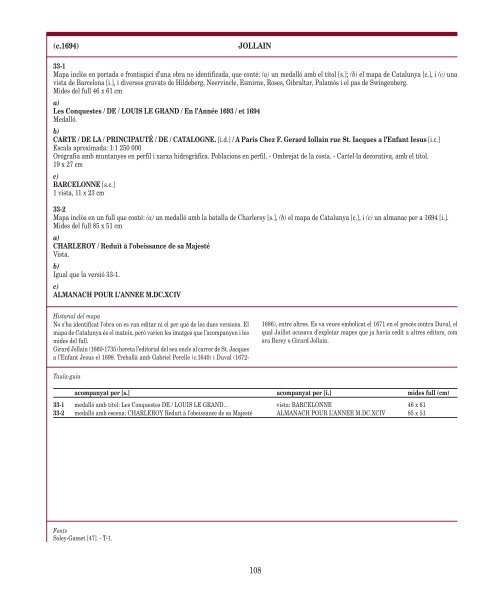
(c.1694) JOLLAIN<br />
33-1<br />
Mapa inclòs en portada o frontispici d’una obra no i<strong>de</strong>ntificada, que conté: (a) un medalló amb el títol [s.]; (b) el mapa <strong>de</strong> <strong>Catalunya</strong> [c.], i (c) una<br />
vista <strong>de</strong> Barcelona [i.], i diversos gravats <strong>de</strong> Hil<strong>de</strong>berg, Neervincle, Esmirne, Roses, Gibraltar, Palamós i el pas <strong>de</strong> Swingenberg.<br />
Mi<strong>de</strong>s <strong><strong>de</strong>l</strong> full 46 x 61 cm<br />
a)<br />
Les Conquestes / DE / LOUIS LE GRAND / En l’Année 1693 / et 1694<br />
Medalló.<br />
b)<br />
CARTE / DE LA / PRINCIPAUTÉ / DE / CATALOGNE. [i.d.] / A Paris Chez F. Gerard Iollain rue St. Iacques a l’Enfant Iesus [i.c.]<br />
Escala aproximada: 1:1 250 000<br />
Orografia amb muntanyes en perfil i xarxa hidrogràfica. Poblacions en perfil. - Ombrejat <strong>de</strong> la costa. - Cartel·la <strong>de</strong>corativa, amb el títol.<br />
19 x 27 cm<br />
c)<br />
BARCELONNE [s.c.]<br />
1 vista, 11 x 23 cm<br />
33-2<br />
Mapa inclòs en un full que conté: (a) un medalló amb la batalla <strong>de</strong> Charleroy [s.], (b) el mapa <strong>de</strong> <strong>Catalunya</strong> [c.], i (c) un almanac per a 1694 [i.].<br />
Mi<strong>de</strong>s <strong><strong>de</strong>l</strong> full 85 x 51 cm<br />
a)<br />
CHARLEROY / Reduït à l’obeissance <strong>de</strong> sa Majesté<br />
Vista.<br />
b)<br />
Igual que la versió 33-1.<br />
c)<br />
ALMANACH POUR L’ANNEE M.DC.XCIV<br />
Historial <strong><strong>de</strong>l</strong> mapa<br />
No s’ha i<strong>de</strong>ntificat l’obra on es van editar ni el per què <strong>de</strong> les dues versions. El<br />
mapa <strong>de</strong> <strong>Catalunya</strong> és el mateix, però varien les imatges que l’acompanyen i les<br />
mi<strong>de</strong>s <strong><strong>de</strong>l</strong> full.<br />
Girard Jollain (1660-1735) hereta l’editorial <strong><strong>de</strong>l</strong> seu oncle al carrer <strong>de</strong> St. Jacques<br />
a l’Enfant Jesus el 1698. Treballà amb Gabriel Perelle (c.1640) i Duval (1672-<br />
Taula-guia<br />
Fonts<br />
Soley-Gasset [47]. - T-1.<br />
1686), entre altres. Es va veure embolicat el 1671 en el procés contra Duval, el<br />
qual Jaillot acusava d’explotar <strong>mapes</strong> que ja havia cedit a altres editors, com<br />
ara Berey o Girard Jollain.<br />
acompanyat per [s.] acompanyat per [i.] mi<strong>de</strong>s full (cm)<br />
33-1 medalló amb títol: Les Conquestes DE / LOUIS LE GRAND... vista: BARCELONNE 46 x 61<br />
33-2 medalló amb escena: CHARLEROY Reduït à l’obeissance <strong>de</strong> sa Majesté ALMANACH POUR L’ANNEE M.DC.XCIV 85 x 51<br />
108