Els mapes del territori de Catalunya durant dos-cents anys, 1600-1800
Els mapes del territori de Catalunya durant dos-cents anys, 1600-1800
Els mapes del territori de Catalunya durant dos-cents anys, 1600-1800

Create successful ePaper yourself
Turn your PDF publications into a flip-book with our unique Google optimized e-Paper software.
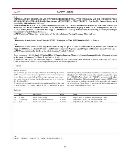
(c.1680) SANSON - BERRY<br />
24-1<br />
CATALONIA UNDER WHICH NAME ARE COMPREHENDED THE PRINCIPALITY OF CATALONIA, AND THE COUNTIES OF ROS-<br />
SILLION AND OF / CERDAGNE, Divi<strong>de</strong>d into its severall VIGUERIES or PROVOST-SHIPS. / Described by Sanson / Corrected &<br />
amen<strong>de</strong>d by William Berry [títol liminar]<br />
PRINCIPALITY OF, / CATALONIA, / in which are Comprehen<strong>de</strong>d / the COUNTIES of ROSSILLION and of CERDAGNE / divi<strong>de</strong>d into<br />
its severall VIGUERIES or PROVOST-SHIP. / To the most Serene & most Sacred Majesty / CHARLES. II. / By the grace of God KING<br />
of Great Britain, France, / and Ireland. This Mapp of CATALONIA is / Humbly Dedicated and Presented By your: / Majesties Loyall<br />
Subject and Servant / William Berry. [i.d.]<br />
LONDON, Sold by William Berry at the Signe of / the Globe, between Chering Cross and White Hall [s.e.]<br />
24-2<br />
...To the most Serene & most Sacred Majesty / ANNE. / By the grace of God QUEEN of Great Britain, France...<br />
24-3<br />
...To the most Serene & most Sacred Majesty / GEORGE II. / By the grace of God KING of Great Britain, France, / and Ireland. This<br />
Mapp of CATALONIA is / Humbly Dedicated and Presented By your: / Majesties Loyall Subject and Servant / Eman: Bowen. [i.d.]<br />
LONDON, printed for John Bowles at the Black House in Cornhill 1740 [s.e.]<br />
Escala aproximada 1:600 000. Scale. 30/Italian Miles; 12/Common Leagues of France; 9/Common Leagues of Spain; 8/Common Leagues<br />
of Germany; 10/Leagues of on Houes Trauelling [= 8,6 cm] [s.e.]<br />
Orla graduada. - Orografia amb muntanyes en perfil i xarxa hidrogràfica. Poblacions en perfil. Divisions <strong>territori</strong>als. - Ombrejat <strong>de</strong> la costa. -<br />
Cartel·les <strong>de</strong>coratives, amb el títol [cavalls i palafreners] i amb l’escala i adreça [pe<strong>de</strong>stal].<br />
53 x 85 cm<br />
Historial <strong><strong>de</strong>l</strong> mapa<br />
Tot i el monopoli que havia aconseguit John Seller, William Berry als volts <strong>de</strong><br />
1680 va treure una col·lecció <strong>de</strong> <strong>mapes</strong> a gran foli basats en els <strong>mapes</strong> <strong>de</strong> Sanson<br />
(li van valdre el sobrenom <strong>de</strong> the English Sanson) que en principi van ser impresos<br />
i venuts per separat, però que el mateix Berry va reunir en un atles sense<br />
títol als volts <strong>de</strong> 1689.<br />
Es coneixen tres versions <strong><strong>de</strong>l</strong> mapa <strong>de</strong> <strong>Catalunya</strong> edita<strong>de</strong>s a Londres. Les dues<br />
primeres no porten any. La datació es pot fer per l’adreça <strong>de</strong> l’editor, ja que<br />
Taula-guia<br />
any <strong>de</strong>dicatòria editor notes<br />
Fonts<br />
COL[22]. - IMCOS[23]. - Tooley, 53, 123. - Tyacke, 109-110. - Ph-LG 3442, 28.<br />
William Berry va treballar a “the Sign of the Globe Between Chering Cross and<br />
White Hall” entre 1676 i 1708, i a partir <strong>de</strong> les <strong>de</strong>dicatòries: Carles II va regnar<br />
entre 1660 i 1685, Anna I Stuart, entre 1702 i 1714. La tercera versió, <strong>de</strong>dicada<br />
a Jordi II i datada el 1740, és <strong>de</strong>guda a Emanuel Bowen (c.1693-1767), gravador<br />
i impressor <strong>de</strong> Londres, que va tenir el títol <strong>de</strong> gravador <strong><strong>de</strong>l</strong>s <strong>mapes</strong> <strong><strong>de</strong>l</strong><br />
rei, i a l’editor John Bowles. Potser va formar part <strong>de</strong> The Large English atlas,<br />
c.1763 o <strong>de</strong> The Royal English atlas, c.1764.<br />
24-1 [c.1680] <strong>de</strong>dicat al rei Carles II W. Berry regnat Carles II, 1660-1685. Recull <strong>de</strong> <strong>mapes</strong> c.1680<br />
24-2 [1702-1708] <strong>de</strong>dicat a la reina Anna I Stuart W. Berry regnat Anna I, 1702-1714. Adreça entre 1676 i 1708<br />
24-3 1740 <strong>de</strong>dicat al rei Jordi II E. Bowen regnat Jordi II, 1727-1760. Ed. Bowen, 1740<br />
90