Els mapes del territori de Catalunya durant dos-cents anys, 1600-1800
Els mapes del territori de Catalunya durant dos-cents anys, 1600-1800
Els mapes del territori de Catalunya durant dos-cents anys, 1600-1800

Create successful ePaper yourself
Turn your PDF publications into a flip-book with our unique Google optimized e-Paper software.
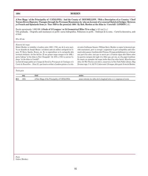
1684 MORDEN<br />
A New Mapp / of the Principality of / CATALONIA. / And the County of / ROUSSILLION. / With a Description of ye Country / Cheif<br />
Townes Rivers Higwaies / Passages through the Pyrenaan Mountaines As / also an Account of ye seuerael Battels & Seidges / Between<br />
ye French and Spaniards from ye / Year 1639 to the prese[n]t 1684 / By Rob. Mor<strong>de</strong>n at the Atlas in / Corn-hill / LONDON [i.d.]<br />
Escala aproximada: 1:800 000. A Scale of 15 Leagues / or 54 Geometrical Miles 72 to a <strong>de</strong>g. [= 9,5 cm] [i.c.]<br />
Orla graduada. - Orografia amb muntanyes en perfil i xarxa hidrogràfica. Poblacions en perfil. - Ombrejat <strong>de</strong> la costa. - Cartel·la <strong>de</strong>corativa, amb<br />
el títol.<br />
38 x 43 cm<br />
Historial <strong><strong>de</strong>l</strong> mapa<br />
Robert Mor<strong>de</strong>n va treballar a Londres entre 1650 i 1703, any <strong>de</strong> la seva mort.<br />
Va ser <strong>de</strong>ixeble <strong>de</strong> Joseph Moxon i col·laborà amb els millors cartògrafs <strong>de</strong> l’època:<br />
W. Berry, Sparke, Bowen, etc. Es va especialitzar en la cartografia <strong><strong>de</strong>l</strong>s<br />
<strong>territori</strong>s britànics i <strong>de</strong> fets bèl·lics. El seu primer mapa conegut és <strong>de</strong> 1669, i<br />
porta l’adreça “at the Atlas in New Cheapsi<strong>de</strong>”. De 1675 a 1703 va canviar l’adreça:<br />
“at the Atlas in Cornhill”.<br />
La font <strong><strong>de</strong>l</strong> mapa podria ser el mapa <strong>de</strong> Duval La Principaute <strong>de</strong> Catalogne et le<br />
Comté <strong>de</strong> Roussillon... [fitxa 21], que hauria arribat a Londres gràcies a la rela-<br />
Taula-guia<br />
any títol notes<br />
Fonts<br />
Galera (Mor<strong>de</strong>n).<br />
ció entre Guillaume Sanson i William Berry. Mor<strong>de</strong>n va copiar la <strong>de</strong>coració gairebé<br />
exactament, però va corregir i augmentar la part cartogràfica amb informació<br />
sobre passos i localitats <strong><strong>de</strong>l</strong>s Pirineus. El mapa probablement no va formar<br />
mai part d’un atles, sinó que va servir per a il·lustrar algun <strong><strong>de</strong>l</strong>s llibres sobre<br />
les guerres europees <strong><strong>de</strong>l</strong> segle XVII, llibre que, per ara, no s’ha pogut localitzar.<br />
Es coneix un exemplar <strong><strong>de</strong>l</strong> mapa inclòs dins d’un atles factici: Miscellaneaus<br />
Atlas: De Witt Thorton and others, conservat a la New York Public Library. Map<br />
Division (sign. C-4), full 70. L’atles conté 110 <strong>mapes</strong>, <strong><strong>de</strong>l</strong>s quals 10 són <strong>de</strong> Mor<strong>de</strong>n.<br />
25-1 1684 A New Mapp of the Principality of CATALONIA sense retícula; les xifres <strong>de</strong> la longitud [orla s.i.i.], impreses al revés<br />
92