Els mapes del territori de Catalunya durant dos-cents anys, 1600-1800
Els mapes del territori de Catalunya durant dos-cents anys, 1600-1800
Els mapes del territori de Catalunya durant dos-cents anys, 1600-1800

You also want an ePaper? Increase the reach of your titles
YUMPU automatically turns print PDFs into web optimized ePapers that Google loves.
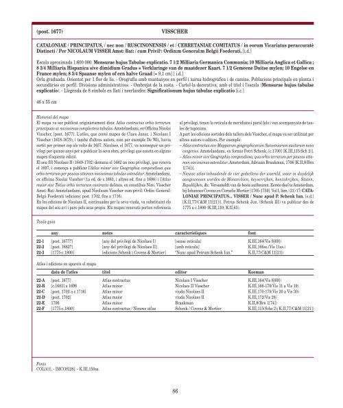
(post. 1677) VISSCHER<br />
CATALONIAE / PRINCIPATUS, / nec non / RUSCINONENSIS / et / CERRETANIAE COMITATUS / in eorum Vicariatus peraccuratè<br />
Distincti / Per NICOLAUM VISSER Amst: Bat: / cum Privil o : Ordin:m General:m Belgii Foe<strong>de</strong>rati. [i.d.]<br />
Escala aproximada 1:600 000. Mensurae hujus Tabulae explicatio. 7 1/2 Milliaria Germanica Communia; 10 Milliaria Anglica et Gallica ;<br />
8 3/4 Milliaria Hispanica sive dimidium Gradus = Verklaringe van <strong>de</strong> maat<strong>de</strong>zer Kaart. 7 1/2 Gemeene Duitse mylen; 10 Engelse en<br />
France mylen; 8 3/4 Spaanse mylen of een halve Graad [= 9,1 cm] [ i.d.]<br />
Orla graduada. Orientat per 1 flor <strong>de</strong> lis. - Orografia amb muntanyes en perfil i xarxa hidrogràfica i <strong>de</strong> camins. Poblacions principals en planta i<br />
secundàries en perfil. Divisions administratives. - Ombrejat <strong>de</strong> la costa. - Cartel·la <strong>de</strong>corativa, amb el títol i l’escala (Mensurae hujus tabulae<br />
explicatio). - Llegenda <strong>de</strong> 8 símbols en llatí i neerlandès: Significationum hujus tabulae explicatio [i.c.]<br />
46 x 55 cm<br />
Historial <strong><strong>de</strong>l</strong> mapa<br />
El mapa va ser publicat originàriament dins: Atlas contractus orbis terrarum<br />
praecipuas ac novissimas complectens tabulas. Amstelaedami, ex Officina Nicolai<br />
Visscher, [post. 1677]. L’atles, que conté <strong>mapes</strong> <strong>de</strong> Claes Jansz. i Nicolaes I<br />
Visscher (1618-1679), i també d’altres autors, com per exemple De Wit, havia<br />
sortit per primer cop als volts <strong>de</strong> 1657. Nicolaes, el 1677, va aconseguir un privilegi<br />
per quinze <strong>anys</strong> per a publicar la seva obra, privilegi que consta en alguns<br />
<strong>mapes</strong> d’aquesta edició.<br />
El seu fill Nicolaes II (1649-1702) <strong>de</strong>mana el 1682 un nou privilegi, que renova<br />
el 1697, i comença a publicar l’Atlas minor sive Geographia compendiosa qua<br />
orbis terrarum per paucas attamen novissimas tabulas ostenditur. Amstelaedami,<br />
ex officina Nicolai Visscher (1a ed. <strong>de</strong> c.1683, i altres ed. fins a 1698) i l’Atlas<br />
maior sive Totius orbis terrarum contracta <strong><strong>de</strong>l</strong>inea. ex conatibus Nico. Visscher<br />
Amst: Bat: Amstelaedami, apud Nicolaum Visscher cum privil: Ordin: General:<br />
Belgii Foe<strong>de</strong>rati (edicions: post. 1702, fins a 1716).<br />
En les edicions <strong>de</strong> Nicolaes II, continua<strong>de</strong>s per la seva viuda, va substituint els<br />
<strong>mapes</strong> <strong><strong>de</strong>l</strong> seu avi i pare pels seus propis. <strong>Els</strong> <strong>mapes</strong> renovats porten referència<br />
Taula-guia<br />
Fonts<br />
COL[41]. - IMCOS[28]. - K.III,150ss.<br />
al privilegi, tenen la retícula <strong>de</strong> meridians i paral·lels i van acompanyats <strong>de</strong> taules<br />
<strong>de</strong> topònims.<br />
A part les edicions sorti<strong>de</strong>s <strong><strong>de</strong>l</strong>s tallers <strong><strong>de</strong>l</strong>s Visscher, el mapa va ser utilitzat per<br />
altres autors o editors. Per exemple:<br />
– Atlas contractus sive Mapparum geographicarum Sansoniarum auctarum nova<br />
congeries. Amstelaedami, ex formis Petri Schenk, [c.1700] [K.III,115(Sch 2)].<br />
– Atlas minor sive Geographia compendiosa, qua orbis terrarum per paucas attamen<br />
novissimas ostenditur. Amsterdam, Adriaan Braakman, 1706 [K.II,8(Brn<br />
1[74])].<br />
– Nieuwe atlas inhou<strong>de</strong>n<strong>de</strong> <strong>de</strong> vier ge<strong>de</strong>eltens <strong>de</strong>r waereld, waar in duy<strong><strong>de</strong>l</strong>ijk<br />
aangeweesen wor<strong>de</strong>n <strong>de</strong> Monarchien, keyserrijken, koninkrijken, Staten,<br />
Republijken, &c. Versameldt van <strong>de</strong> beste autheuren. Eerste <strong>de</strong>el te Amsterdam,<br />
bij Iohannes Covens en Cornelis Mortier [1705-1759]. Vol I, làm. (21) 17: CATA-<br />
LONIAE PRINCIPATUS... VISSER / Nunc apud P. Schenk Iun. [s.d.]<br />
[K.II,77(C&M 11[21])]. Petrus Schenk Jun. (Schenk III) va publicar <strong>de</strong>s <strong>de</strong><br />
1775 a c.<strong>1800</strong> (K.III,110; K.II,63).<br />
any notes característiques font<br />
22-1 [post. 1677?] [any <strong><strong>de</strong>l</strong> privilegi <strong>de</strong> Nicolaes I] [sense retícula] K.III,164(Vis 8[69])<br />
22-2 [post. 1682?] [any <strong><strong>de</strong>l</strong> privilegi <strong>de</strong> Nicolaes II] [amb retícula] K.III,166ss.(Vis 11ss.)<br />
22-3 [1775-c.<strong>1800</strong>] [edicions Schenk i Covens & Mortier] “Nunc apud Petrum Schenk Iun.” K.II,77(C&M 11[21])<br />
Atles i edicions on apareix el mapa<br />
data <strong>de</strong> l’atles títol editor Koeman<br />
22-A [post. 1677] Atlas contractus Nicolaes I Visscher K.III,164(Vis 8[69])<br />
22-B [c.1683] a 1698 Atlas minor Nicolaes II Visscher K.III,166-170(Vis 11 a Vis 19)<br />
22-C [post. 1702 a c.1716] Atlas minor viuda Nicolaes II K.III,170-175(Vis 20 a Vis 30)<br />
22-D [post. 1702] Atlas maior viuda Nicolaes II K.III,172(Vis 28)<br />
22-E 1706 Atlas minor Braakman K.II,8(Brn 1[74])<br />
22-F [1775-c.<strong>1800</strong>] Atlas contractus / Nieuwe atlas Schenk / Covens & Mortier K.III,115(Sche 2); K.II,77(C&M 11[21])<br />
86