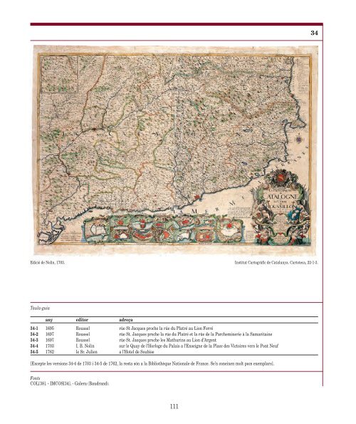
1695 BAUDRAND - ROUSSEL - NOLIN Es coneixen cinc edicions <strong><strong>de</strong>l</strong> mapa, molt semblants però amb adreces i <strong>anys</strong> diferents. Només s’ha consultat la 34-4 i, per aquest motiu, és l’única on es transcriuen els canvis <strong>de</strong> caixa <strong><strong>de</strong>l</strong> text. En canvi, les variacions en el títol prenen com a referència la 34-1. 34-1 La Principauté / <strong>de</strong> / Catalogne / et / le Comté / <strong>de</strong> / Roussillon / Suivant les Nouvelles observations / par / le Sieur abbé Baudrand / <strong>de</strong>diez / a monseigneur / monseigneur / le Marechal duc <strong>de</strong> Noaïlles, / pair <strong>de</strong> France, / Chevalier <strong>de</strong>s / ordres du Roy, Premier / Capitaine <strong>de</strong> ses gar<strong>de</strong>s, Gouver- / neur du Roussillon, Viceroy / et General <strong>de</strong>s Armées <strong>de</strong> / sa Majesté en Catalogne / Par son tres humble et tres / Obeissant Serviteur C. Roussel; / ces epreuves ont été veu et corrigées, / par l’ordre <strong>de</strong> monseigneur le marechal / duc <strong>de</strong> Noaïlles // à Paris: Chez C. Roussel, / Graveur Rüe St. Iacques proche la Rüe du Platré au Lion Ferré, / Avec Privilege du Roi. / 1695. [i.d.] gravé par C. Roussel [i.d.] / P. Le Pautre inv. [i.d.] Escala aproximada: 1:350 000. Echelles. 3/Lieües communes d’Espagne [= 4,8 cm]; 6/Petites Lieües <strong>de</strong> France; 5/Lieües communes <strong>de</strong> France; 4/Gran<strong>de</strong>s Lieües <strong>de</strong> France [= 5,9 cm] [i.e.] Orla graduada. Orientat per 1 rosa <strong><strong>de</strong>l</strong>s vents flor<strong><strong>de</strong>l</strong>isada. - Orografia amb muntanyes en perfil i xarxa hidrogràfica i <strong>de</strong> camins. Poblacions principals en planta i secundàries en perfil. Divisions administratives. - Ombrejat <strong>de</strong> la costa. - Finestres amb plànols <strong>de</strong> 12 places fortes: Barcelone, Rose, Tortose, Palamos, Ostalric, Castel-Foilit, Girone, Tarragone, Collioure, Lerida, Mont-Louis, Perpignan [i.c.], i finestra 11 x 11 cm, sense títol <strong>de</strong>stacat: VALLÉE D’ARAN [s.e.]. - Cartel·les <strong>de</strong>coratives, amb el títol, <strong>de</strong>dicatòria i adreça, i amb els plànols. Fora <strong>de</strong> les cartel·les, escala, nota i llegenda <strong>de</strong> 12 símbols convencionals: Explication [s.d.]. 58 x 85 cm Historial <strong><strong>de</strong>l</strong> mapa Mapa <strong>de</strong> caràcter militar, amb un interès especial per les vies <strong>de</strong> comunicació i les places fortes, que il·lustra el llibre <strong>de</strong> memòries <strong><strong>de</strong>l</strong> duc <strong>de</strong> Noailles recopila<strong>de</strong>s per l’abbé Millot. El mapa fou realitzat per Michel Antoine Baudrand, geògraf, i publicat primer per Clau<strong>de</strong> Roussel, i <strong>de</strong>sprés per Jean Baptiste Nolin (1657-1705), geògraf <strong><strong>de</strong>l</strong> rei <strong>de</strong>s <strong>de</strong> 1701. Pierre Le Pautre va dibuixar la cartel·la. 110 Hi ha una edició <strong>de</strong> 1762 [34-5], amb l’adreça <strong>de</strong> Le Sieur Roth-Joseph Julien, que va treballar a París entre 1750 i 1780, à l’Hotel <strong>de</strong> Soubise. Va tenir el títol <strong>de</strong> geògraf <strong><strong>de</strong>l</strong> rei, va fer <strong>de</strong> marxant <strong>de</strong> <strong>mapes</strong> i d’editor, i va col·laborar amb els Homann, els Rocque i Sayer & Bennett, etc. Va publicar, entre altres, un Atlas géographique et militaire <strong>de</strong> la France el 1751, i el Theatre du mon<strong>de</strong>, el 1768. 34-2 <strong>de</strong>diez / a monseigneur ... gouverneur du Roussillon, viceroy et general <strong>de</strong>s armées <strong>de</strong> Catalogne ... À PARIS: / Chez C. Roussel, / Graveur rüe St. Jacques proche la / Rüe du Platré et la Rüe <strong>de</strong> la / Parcheminerie à la Samaritaine, Avec privilege du Roy. / 1697 Nota, entre cartel·la i plànols: Nouvelle Carte particulier <strong>de</strong> la / Catalogne et du Roussillon en <strong>de</strong>ux gran<strong>de</strong>s / feuilles divisez suivant l’etendue <strong>de</strong> tous leurs / Vigueries avec les Plans <strong>de</strong> leurs Principales Places. Dressée sur les memoires <strong>de</strong> / Monseigr. le Marechal duc <strong>de</strong> Noaille / Ces epreuves ont eté veu et corregées / par l’ordre <strong>de</strong> Monseigneur le Marechal / Duc <strong>de</strong> Nöailles en 1697. [i.d.]. 34-3 <strong>de</strong>diez / a monseigneur ... general <strong>de</strong>s armées <strong>de</strong> Catalogne par son tres humble et tres obeissant serviteur C. Roussel; dressé sur les memoires <strong>de</strong> monseigr. le marechal <strong>de</strong> Noaïlles; ... À Paris: chez C. Roussel, graveur rüe St. Jacques proche les Mathurins au Lion d’Argent, 1697. 34-4 LA PRINCIPAUTÉ / DE / CATALOGNE / et / LE COMTÉ / DE / ROUSSILLON / Suivant les Nouvelles observations / par / le SIEUR ABBÉ BAUDRAND // DEDIEZ / A MONSEIGNEUR / MONSEIGNEUR / LE MARECHAL DUC DE / NÖAILLES / Pair <strong>de</strong> France / Chevalier <strong>de</strong>s / ordres du Roy, Premier / Capitaine <strong>de</strong> ses Gar<strong>de</strong>s, Gouver / neur du Roussillon &c. / Par / son tres humble Serviteur / I.B. Nolin Géographe Ord. / du Roy // A PARIS / chez I.B. Nolin Geographe / Ordinaire du Roy sur le Quay / <strong>de</strong> l’Horloge du Palais a / l’Enseigne <strong>de</strong> la Place <strong>de</strong>s / Victoires vers le Pont / Neuf. Avec Privil. / du Roy 1703 [i.d.] Gravé par C. Roussel [i.d.] / P. le Pautre inv. [i.d.] Nota, entre cartel·la i plànols: Cette carte <strong>de</strong> la Catalogne et du / Roussillon, est la plus particuliere / qui à paru, elle est divisée suivant / leurs Vigueries, auec les Chemins / et les Plans <strong>de</strong>s Principales Places. / Dressée sur les memoires <strong>de</strong> Monseig. / le Marechal Duc <strong>de</strong> Noaïlles. [<strong>Els</strong> noms <strong>de</strong> les places fortes són impresos en cintes dins <strong>de</strong> cada finestra, però són gairebé esborrats, i s’han repetit a la part <strong>de</strong> fora <strong>de</strong> manera poc cuida<strong>dos</strong>a]. 34-5 <strong>de</strong>diez / a monseigneur ... Gouver / neur du Roussillon &c. / Par / son tres humble Serviteur / I.B. Nolin, geographe ord. du roy; dressé sur les memoires <strong>de</strong> monseig.r le marechal duc <strong>de</strong> Noaïlles À PARIS: Chez le Sr. Julien a l’Hotel <strong>de</strong> Soubise, / Avec Privilege du Roy / du 25 Janvier 1762 Gravé par C. Roussel
Edició <strong>de</strong> Nolin, 1703. Taula-guia any editor adreça Fonts COL[38]. - IMCOS[34]. - Galera (Baudrand). 111 34 Institut Cartogràfic <strong>de</strong> <strong>Catalunya</strong>. Cartoteca, 22-1-3. 34-1 1695 Roussel rüe St Jacques proche la rüe du Platré au Lion Ferré 34-2 1697 Roussel rüe St. Jacques proche la rüe du Platré et la rüe <strong>de</strong> la Parcheminerie à la Samaritaine 34-3 1697 Roussel rüe St. Jacques proche les Mathurins au Lion d’Argent 34-4 1703 I. B. Nolin sur le Quay <strong>de</strong> l’Horloge du Palais a l’Enseigne <strong>de</strong> la Place <strong>de</strong>s Victoires vers le Pont Neuf 34-5 1762 le Sr. Julien a l’Hotel <strong>de</strong> Soubise [Excepte les versions 34-4 <strong>de</strong> 1703 i 34-5 <strong>de</strong> 1762, la resta són a la Bibliothèque Nationale <strong>de</strong> France. Se’n coneixen molt pocs exemplars].