- Page 1 and 2:
ELS MAPES DEL TERRITORI DE CATALUNY
- Page 3 and 4:
ELS MAPES DEL TERRITORI DE CATALUNY
- Page 5:
SUMARI Presentació . . . . . . . .
- Page 8 and 9:
l’Associació de Bibliòfils de B
- Page 11:
INTRODUCCIÓ 11
- Page 14 and 15:
gràfics, pot ajudar a situar i a c
- Page 16 and 17:
classes socials. La seva presentaci
- Page 18 and 19:
Breus comentaris sobre les obres de
- Page 20 and 21:
Ejército, Centro Geográfico del E
- Page 22 and 23:
seleccionat per formar part d’aqu
- Page 24 and 25:
si en la planta del Principat que d
- Page 26 and 27:
publicava aquest text dipositat al
- Page 28 and 29:
El seu primer treball conegut en aq
- Page 30 and 31:
cions lleugerament diferents trebal
- Page 32 and 33:
Nova Principatvs Cataloniæ Descrip
- Page 34 and 35:
1605 “...mapes... fetes per talla
- Page 37:
CATÀLEG 37
- Page 40 and 41:
- El número d’ordre s’ha estab
- Page 42 and 43:
NMM National Maritime Museum: catal
- Page 44 and 45:
(1602-1605) VRIENTS 1-1 NOVA PRINCI
- Page 46 and 47:
(1602-1605) ORTELIUS (T.O.T.) - VRI
- Page 48 and 49:
[1609] ORTELIUS (Epitome) - VRIENTS
- Page 50 and 51:
[1611] MERCATOR - HONDIUS CATALONIA
- Page 52 and 53:
[1630] MERCATOR - HONDIUS - CLOPPEN
- Page 54 and 55:
[1633] TASSIN CATALO / nia. [s.d.]
- Page 56 and 57:
[1634] BLAEU 7-1 CATALONIA [s.e.] G
- Page 58 and 59:
[1635] MERCATOR - SPARKE CATALONIA
- Page 60 and 61:
[1635?] [anònim] CATALONIA [s.e.]
- Page 62 and 63:
[1638] JANSSONIUS - HONDIUS CATALON
- Page 64 and 65:
(1640-1645) LOCHOM - MARIETTE 11-1
- Page 66 and 67:
1642 BOISSEAU 12-1 NOVVELLE DESCRIP
- Page 68 and 69:
1642 TASSIN 13-1 DESCRIPTION / DE /
- Page 70 and 71:
1643 PELLICER DESCRIPCION / Del Pri
- Page 72 and 73:
[1648] JANSSONIUS 15-1 CATALO= / NI
- Page 74 and 75:
[1649] GUCHEN - BURDIGALENSIS - MON
- Page 76 and 77:
1660 SANSON PRINCIPAUTÉ de / CATAL
- Page 78 and 79:
(post. 1660) WIT Accuratissima / PR
- Page 80 and 81:
(c.1662) BEAULIEU Carte / de la / P
- Page 82 and 83:
1674 SANSON - JAILLOT 20-1 LA CATAL
- Page 84 and 85:
1677 DUVAL la PRINCIPAUTÉ de / CAT
- Page 86 and 87:
(post. 1677) VISSCHER CATALONIAE /
- Page 88 and 89:
168[.] JAILLOT PRINCIPAUTÉ DE CATA
- Page 90 and 91:
(c.1680) SANSON - BERRY 24-1 CATALO
- Page 92 and 93:
1684 MORDEN A New Mapp / of the Pri
- Page 94 and 95:
[1686] VAQUER - TRISTANY [Sant Jord
- Page 96 and 97:
[1688] CORDIER - MARCA MARCA HISPAN
- Page 98 and 99:
1690 CANTELLI DA VIGNOLA - ROSSI IL
- Page 100 and 101:
(post. 1690) WIT - MORTIER Accurati
- Page 102 and 103:
(post. 1690) SANSON - MORTIER NOVA
- Page 104 and 105:
1691 CANTEL - TILLEMON - NOLIN LA P
- Page 106 and 107:
1692 SANSON - JAILLOT - MORTIER - H
- Page 108 and 109: (c.1694) JOLLAIN 33-1 Mapa inclòs
- Page 110 and 111: 1695 BAUDRAND - ROUSSEL - NOLIN Es
- Page 112 and 113: 1696 JAILLOT - MORTIER NOVA PRINCIP
- Page 114 and 115: (1696-1717) DANCKERTS PRINCIPATUS /
- Page 116 and 117: [1697] ALLARD Accuratissima / PRINC
- Page 118 and 119: (1699-1710) SANSON - HALMA - MORTIE
- Page 120 and 121: (1700?) DUCHATEL CARTE / DE / CATAL
- Page 122 and 123: (1700-1717?) PETRINI IL PRINCIPATO
- Page 124 and 125: (c.1702) VALCK PRINCIPAUTE DE / CAT
- Page 126 and 127: 1705 HARRIS Mapa inclòs en un full
- Page 128 and 129: [1705] FER PRINCIPAUTÉ / DE / CATA
- Page 130 and 131: [1705-1714] STRIDBECK - BODENEHR 44
- Page 132 and 133: 1706 PLACIDE 45-1 LA / CATALOGNE /
- Page 134 and 135: [1706] LA FEUILLE PRINCIPAUTÉ / DE
- Page 136 and 137: [1707] AA 47-1 KAART VAN CATALONIEN
- Page 138 and 139: (1707?) HOMANN PRINCIPATUS / CATALO
- Page 140 and 141: [1709] VALCK PRINCIPATUS CATALONIAE
- Page 142 and 143: [1712-1713] CASSINE PROVINCIA / CAT
- Page 144 and 145: 1714 FER 51-1 LA PRINCIPAUTÉ DE /
- Page 146 and 147: (1717?) INSELIN LE / ROUSSILLON / E
- Page 148 and 149: 1720 APARICI 53-1 NUEVA DESCRIPCION
- Page 150 and 151: (c.1725) SEUTTER CATALONIAE / PRINC
- Page 152 and 153: 1726 DARNIUS Nueuo Mapa DEL PRINCIP
- Page 154 and 155: [1739] FRANCESCHINI PROVINCIA / GOT
- Page 156 and 157: 1756 TOMÁS LÓPEZ 57-1,2 CATA- / L
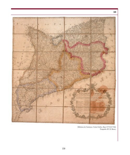
- Page 160 and 161: [1774] BERGER - GUISCHARD CARTE / d
- Page 162 and 163: 1776 TOMÁS LÓPEZ 60-1 MAPA / DEL
- Page 164 and 165: 1781 ESPINALT GARCIA MAPA / DEL PRI
- Page 166 and 167: [1791] REILLY Das FÜRSTENTHUM / CA
- Page 168 and 169: 1798 GÜSSEFELD - HOMANN ERBEN Le P
- Page 170 and 171: [1798] [BERGER] - PEREYRA DESCRIPCI
- Page 172 and 173: 172
- Page 174 and 175: 174
- Page 176 and 177: Danckerts, Cornelis (II) (1664-1717
- Page 178 and 179: Stridbeck, Johann (II) (1666-1714;
- Page 180 and 181: CATALONIA (anònim 1635?): 9 (Blaeu
- Page 182 and 183: NUEVA DESCRIPCION GEOGRAPHICA DEL /
- Page 184 and 185: 184
- Page 186 and 187: 186
- Page 188 and 189: C-2001 IMCOS COL Col 39 38 43 40 45
- Page 190 and 191: 190
- Page 192 and 193: 192
- Page 194 and 195: lización previa de una plancha hec
- Page 196 and 197: antes, visto el tiempo que requerí
- Page 198 and 199: ién da razón de las ediciones fac
- Page 200 and 201: 2. En segundo lugar, y excepcionalm
- Page 202 and 203: Si hemos de hacer una valoración c
- Page 204 and 205: el año de su publicación en estos
- Page 206 and 207: Se trata de un mapa casi idéntico
- Page 208 and 209:
vieron a publicarse -tal como la pr