I-10 Twin Peaks Traffic Interchange, Environmental Assessment
I-10 Twin Peaks Traffic Interchange, Environmental Assessment
I-10 Twin Peaks Traffic Interchange, Environmental Assessment
You also want an ePaper? Increase the reach of your titles
YUMPU automatically turns print PDFs into web optimized ePapers that Google loves.
Alternatives October 2005<br />
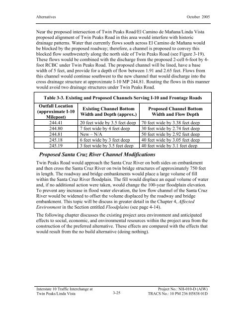
Near the proposed intersection of <strong>Twin</strong> <strong>Peaks</strong> Road/El Camino de Mañana/Linda Vista<br />
proposed alignment of <strong>Twin</strong> <strong>Peaks</strong> Road in this area would interfere with historic<br />
drainage patterns. Water that currently flows south across El Camino de Mañana would<br />
be blocked by the proposed roadway; therefore, a channel is proposed to convey this<br />
blocked flow southwesterly along the north side of <strong>Twin</strong> <strong>Peaks</strong> Road (see Figure 3-19).<br />
These flows would be combined with the discharge from the proposed 2-cell 6-foot by 4foot<br />
RCBC under <strong>Twin</strong> <strong>Peaks</strong> Road. The proposed channel will be lined, have a base<br />
width of 5 feet, and provide for a depth of flow between 1.91 and 2.65 feet. Flows from<br />
this channel would continue southwest to the new channel that would discharge into the<br />
cross drainage structure at approximate I-<strong>10</strong> MP 244.81. Routing the flows in this manner<br />
would avoid two drainage structures under <strong>Twin</strong> <strong>Peaks</strong> Road.<br />
Table 3-3. Existing and Proposed Channels Serving I-<strong>10</strong> and Frontage Roads<br />
Outfall Location<br />
(approximate I-<strong>10</strong><br />
Milepost)<br />
Interstate <strong>10</strong> <strong>Traffic</strong> <strong>Interchange</strong> at<br />
<strong>Twin</strong> <strong>Peaks</strong>/Linda Vista<br />
Existing Channel Bottom<br />
Width and Depth (approx.)<br />
3-25<br />
Proposed Channel Bottom<br />
Width and Flow Depth<br />
244.41 20 feet wide by 3.5 feet deep 70 feet wide by 3.38 feet deep<br />
244.80 7 feet wide by 4 feet deep 30 feet wide by 2.74 feet deep<br />
244.81 New – N/A 50 feet wide by 2.92 feet deep<br />
245.18 6 feet wide by 3 feet deep 40 feet wide by 3.05 feet deep<br />
245.19 3 feet wide by 3.5 feet deep 40 feet wide by 3.1 feet deep<br />
Proposed Santa Cruz River Channel Modifications<br />
<strong>Twin</strong> <strong>Peaks</strong> Road would approach the Santa Cruz River on both sides on embankment<br />
and then cross the Santa Cruz River on twin bridge structures of approximately 750 feet<br />
in length. The roadway and bridge embankments would place a large volume of fill<br />
within the Santa Cruz River floodplain. The fill would displace an equal volume of water<br />
and, if no additional action were taken, would change the <strong>10</strong>0-year floodplain elevation.<br />
To prevent any increase in flood water elevation, the low flow channel of the Santa Cruz<br />
River would be widened to offset the volume displaced by the roadway and bridge<br />
embankment. This topic will be discuss in greater detail in the Chapter 4, Affected<br />
Environment in the Section entitled Floodplains (see page 4-14).<br />
The following chapter discusses the existing project area environment and anticipated<br />
effects to social, economic, and environmental resources within the project area from the<br />
construction of the preferred alternative. These effects are compared with the effects that<br />
would result from the no build alternative (doing nothing).<br />
Project No.: NH-0<strong>10</strong>-D (AIW)<br />
TRACS No.: <strong>10</strong> PM 236 H5838 01D


