

I-10 Twin Peaks Traffic Interchange, Environmental Assessment
I-10 Twin Peaks Traffic Interchange, Environmental Assessment
I-10 Twin Peaks Traffic Interchange, Environmental Assessment

Create successful ePaper yourself
Turn your PDF publications into a flip-book with our unique Google optimized e-Paper software.
Affected Environment and <strong>Environmental</strong> Impacts October 2005<br />
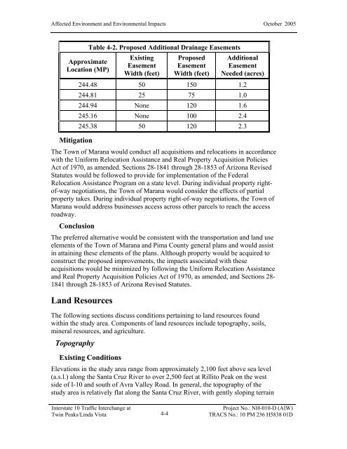
Approximate<br />
Location (MP)<br />
Mitigation<br />
Table 4-2. Proposed Additional Drainage Easements<br />
Existing<br />
Easement<br />
Width (feet)<br />
Proposed<br />
Easement<br />
Width (feet)<br />
Additional<br />
Easement<br />
Needed (acres)<br />
244.48 50 150 1.2<br />
244.81 25 75 1.0<br />
244.94 None 120 1.6<br />
245.16 None <strong>10</strong>0 2.4<br />
245.38 50 120 2.3<br />
The Town of Marana would conduct all acquisitions and relocations in accordance<br />
with the Uniform Relocation Assistance and Real Property Acquisition Policies<br />
Act of 1970, as amended. Sections 28-1841 through 28-1853 of Arizona Revised<br />
Statutes would be followed to provide for implementation of the Federal<br />
Relocation Assistance Program on a state level. During individual property rightof-way<br />
negotiations, the Town of Marana would consider the effects of partial<br />
property takes. During individual property right-of-way negotiations, the Town of<br />
Marana would address businesses access across other parcels to reach the access<br />
roadway.<br />
Conclusion<br />
The preferred alternative would be consistent with the transportation and land use<br />
elements of the Town of Marana and Pima County general plans and would assist<br />
in attaining these elements of the plans. Although property would be acquired to<br />
construct the proposed improvements, the impacts associated with these<br />
acquisitions would be minimized by following the Uniform Relocation Assistance<br />
and Real Property Acquisition Policies Act of 1970, as amended, and Sections 28-<br />
1841 through 28-1853 of Arizona Revised Statutes.<br />
Land Resources<br />
The following sections discuss conditions pertaining to land resources found<br />
within the study area. Components of land resources include topography, soils,<br />
mineral resources, and agriculture.<br />
Topography<br />
Existing Conditions<br />
Elevations in the study area range from approximately 2,<strong>10</strong>0 feet above sea level<br />
(a.s.l.) along the Santa Cruz River to over 2,500 feet at Rillito Peak on the west<br />
side of I-<strong>10</strong> and south of Avra Valley Road. In general, the topography of the<br />
study area is relatively flat along the Santa Cruz River, with gently sloping terrain<br />
Interstate <strong>10</strong> <strong>Traffic</strong> <strong>Interchange</strong> at<br />
<strong>Twin</strong> <strong>Peaks</strong>/Linda Vista<br />
4-4<br />
Project No.: NH-0<strong>10</strong>-D (AIW)<br />
TRACS No.: <strong>10</strong> PM 236 H5838 01D


