- Page 1:
£ ^s^, '
- Page 4:
GENEALOGY COLLecTI •* KHI^
- Page 11 and 12:
History of Middlesex County, MASSAC
- Page 13:
1131986 CONTENTS.
- Page 17 and 18:
west ; HISTORY OF MIDDLESEX COUNTY.
- Page 19 and 20:
of Lexington, near the line of Walt
- Page 21 and 22:
and convert a goodly portion of the
- Page 23 and 24:
ever paid a sacred attention to thi
- Page 25 and 26:
Such a pledge given in religious tr
- Page 29 and 30:
probably Concord was the place of t
- Page 31 and 32:
" Disperse, ye rebels ; lay down yo
- Page 33 and 34:
sacrifice to the lawless oppression
- Page 35 and 36:
uiuuled from tlie voacl iuid with a
- Page 37 and 38:
town. After the close of the Revolu
- Page 39 and 40:
Revolution, such as swords, guus, p
- Page 41 and 42:
the spot where tlie first organized
- Page 43 and 44:
ciliatory character ; and -(vhile w
- Page 45 and 46:
others, inhabitants of the easterly
- Page 47 and 48:
1747 and 1748, without receiving an
- Page 49 and 50:
over, with a noise resembling the d
- Page 51 and 52:
thirty-first day of August, 1774, u
- Page 53 and 54:
Wheeler were chosen a committee to
- Page 55 and 56:
the neighboring towns, especially G
- Page 57 and 58:
above-mentioned families, among who
- Page 59 and 60:
of our Eights and Privileges when c
- Page 61 and 62:
with an occasional lecture precedin
- Page 63 and 64:
0\VELL, ill Middlesex County, State
- Page 65 and 66:
In 1813 Mr. John Goulding invented
- Page 67 and 68:
until he had arrived at the age of
- Page 71 and 72:
Pawtucket Falls ; but John Worthen
- Page 73 and 74:
the Merrimack Company, a quit-claim
- Page 75 and 76:
called upon to participate in the m
- Page 77 and 78:
Dr. Israel Hildreth delivered the o
- Page 79 and 80:
sidered a great improvement. These,
- Page 81 and 82:
The hour of the third meeting arriv
- Page 83 and 84:
for distribution. At the meeting, F
- Page 85:
5{ 2l i
- Page 88 and 89:
76 HISrORY OF MIDDLESEX COUNTY. deg
- Page 90 and 91:
78 HISTORY OF MIDDLESEX COUNTY. for
- Page 92:
80 HISTORY OF MIDDLESEX COUNTY. res
- Page 96 and 97:
84 HISTOBY OF MIDDLESEX COUNTY. sho
- Page 98 and 99:
is recorded a? one of the iucor])or
- Page 100 and 101:
you. It represents my whole command
- Page 102 and 103:
90 HISTORY OF MIDDLESEX COUNTY. wer
- Page 104 and 105:
James W. Hart, 89 men ; Company E,
- Page 106 and 107:
94 HISTOEY OF MIDDLESEX COUXTY. 187
- Page 108 and 109:
homej received an enthusiastic rece
- Page 110 and 111:
98 HISTORY OF MIDDLESEX COUNTY. The
- Page 112 and 113:
100 HISTORY OF mDDLESEJ roUXTY. and
- Page 114:
102 HISTORY OF MIDDLESEX COUNTY. Da
- Page 118 and 119:
106 HISTORY OF MIDDLESEX COUNTY. pr
- Page 120 and 121:
108 HISTORY OF MIDDLESEX COUNTY. th
- Page 122 and 123:
no EISTOBY OF MIDDLESEX COUNTY. tha
- Page 124 and 125:
112 HISTORY OF MIDDLESEX COUNTY. sc
- Page 126 and 127:
114 HIHTORY OF MIDDLESEX COUNTY. eq
- Page 128 and 129:
116 mSTOBY OF MIDDLESEX COUNTY. gra
- Page 130 and 131:
118 HISTORY OF MIDDLESEX COUNTY. to
- Page 132 and 133:
120 HISTOBY OF MIDDLESEX COUNTY. ha
- Page 134 and 135:
122 HISTORY OF MIDDLESEX COUNTY. pi
- Page 136 and 137:
124 HISTORY OF MIDDLESEX COUNTY. th
- Page 138 and 139: 126 HI8T0BY OF MIDDLESEX COUNTY. Ku
- Page 140 and 141: 128 HISTORY OF MIDDLESEX COUNTY. Dr
- Page 142 and 143: 130 HISTORY OF MIDDLESEX COUNTY. th
- Page 144 and 145: 132 HISTORY OF MIDDLESEX COUNTY. br
- Page 146 and 147: 134 HISTORY OF MIDDLESEX COUNTY. du
- Page 148: 13 HISTOHY OF MIDDLESEX COUNTY. res
- Page 152: acre upon all house-lots in the pla
- Page 156 and 157: 145 HISTOnV OF MIDDLESEX COUNTY. la
- Page 158 and 159: 144 HISTORY OF MIDDLESEX COUNTY ill
- Page 160 and 161: 146 IIISTOBY OF MIDDLESEX COUNTY. d
- Page 162 and 163: 148 HISTORY OF MIDDLESEX COUNTY. er
- Page 164 and 165: 150 HISTORY OF MIDDLESEX COUNTY. In
- Page 166 and 167: 15.3 HISTORY OF MIDDLESEX COUXTY. o
- Page 168 and 169: 154 HISTORY OF MIDDLESEX COUNTY. th
- Page 170 and 171: 156 HISTOBY OF MIDDLESEX COUXTY. Br
- Page 172 and 173: 158 m^TVRY OF MIDDLESEX COUXTY. IKE
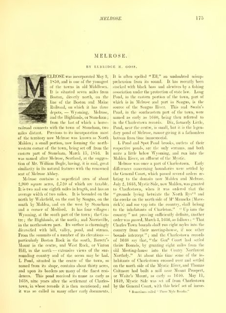
- Page 174 and 175: IGO HISTOHV OF MIDDLESEX COUXTY. "T
- Page 176: 162 Silgamore John, whose Indian na
- Page 180 and 181: IGG HISTORY OF MIDDLESEX COUNTY. Of
- Page 182 and 183: I6y HISTOBY OF 2MIDDLESEX COUNTY. p
- Page 184 and 185: 170 HISTOEY OF MIDDLESEX COUXTY. Fl
- Page 186 and 187: 172 HISTORY OF MIDDLESEX rOUXTY. "T
- Page 190 and 191: 176 HISTOBY OF MIDDLESEX COUNTY. po
- Page 192 and 193: 178 HISTORY OF MIDDLESEX COUNTY. Th
- Page 194 and 195: 180 HISTOBY OF MIDDLESEX COUNTY. Jo
- Page 196 and 197: -182 HISTORY OF MIDDLESEX COUNTY. b
- Page 198 and 199: 184 HISTORY OF MIDDLESEX COUNTY. te
- Page 200 and 201: 18G HISTORY OF MIDDLESEX COUNTY. to
- Page 202 and 203: 188 HISTOBY OF MIDDLESEX COUNTY. Cl
- Page 204 and 205: 190 HISTORY OF MIDDLESEX COUNTY. pu
- Page 206 and 207: 192 HISTORY OF MIDDLESEX COUNTY. fl
- Page 208 and 209: 194 HISTORY OF MIDDLESEX COUNTY. be
- Page 210 and 211: 196 HISTORY OF MIDDLESEX COUNTY. ce
- Page 212 and 213: 198 HISTORY OF MIDDLESEX COLLYTV. ^
- Page 214 and 215: 200 HISTORY OF MIDBLESEX COUNTY. In
- Page 216 and 217: 202 HISTORY OF MIDDLESEX COUNTY. ga
- Page 218 and 219: 204 HISTORY OF MIDDLESEX COUNTY. it
- Page 220 and 221: 206 HIHTORY OF MIDDLESEX COUXTY. ho
- Page 222 and 223: 208 HISTORY OF MIDDLESEX COUNTY. of
- Page 224 and 225: 210 HISTORY OF MIDDLESEX COUXTY. se
- Page 226 and 227: 21; HISTORY OF MIDDLESEX COUNTY. 16
- Page 228 and 229: 214 meeting-house, except two or tl
- Page 230 and 231: 216 HISTORY OF MIDDLESEX COUXTY. to
- Page 232 and 233: 21S IIISTOBY OF MIDDLESEX COUNTY. t
- Page 234 and 235: 220 bursement of moneys which shoul
- Page 236 and 237: 222 HISTORY OF MIDDLESEX COUNTY. wa
- Page 238 and 239:
and individuals their places in iLe
- Page 240 and 241:
• 226 HISTORY OF MIBBLEHEX COUNTY
- Page 242 and 243:
228 In tlie warrant for the town-me
- Page 244 and 245:
1-60 HISTOBY OF MIDDLESEX COUNTY. l
- Page 246 and 247:
2S-2 HISTOEY OF MIDDLESEX COUNTY. w
- Page 248 and 249:
•2U HISTORY OF MIDDLESEX COFXTY.
- Page 250 and 251:
236 HISTORY OF MIDDLESEX COUNTY. In
- Page 252 and 253:
238 HISTOBY OF MIDDLESEX COUNTY. po
- Page 254 and 255:
240 HISTORY OF MIDDLESEX COUNTY. pa
- Page 256 and 257:
242 HISTORY OF MIDDLESEX COUNTY. $
- Page 258 and 259:
244 HISTOBY OF MIDDLESEX COUNTY. Ja
- Page 260 and 261:
246 HISTORY OF MIDDLESEX COUXTY. or
- Page 262 and 263:
248 HISTORY OF MIDDLESEX COUNTY. th
- Page 264 and 265:
5oU HISTORY OF MIDDLESEX COUNTY. fi
- Page 266 and 267:
252 HISTORY OF MIDDLESEX COUNTY. au
- Page 268 and 269:
254 HISTORY OF MIDDLESEX COUNTY. Wh
- Page 270 and 271:
256 to aid in the evangelization of
- Page 272:
J58 HISTORY OF MIDDLE8EX COUA'TY. c
- Page 276 and 277:
260 HISTORY OF MIDDLESEX COUNTY. pe
- Page 278 and 279:
2G; HISTORY OF MIDDLESEX COUNTY. li
- Page 280 and 281:
264 HISTORY OF MIDDLESEX COUNTY col
- Page 282 and 283:
266 HISTORY OF MIDDLESEX COUNTY gan
- Page 284 and 285:
268 HISTORY OF MIDDLESEX COUNTY. 17
- Page 286 and 287:
270 HISTOEY OF MIDDLESEX COUNTY. RE
- Page 288 and 289:
272 HISrOBY OF MIDDLESEX COUNTY. so
- Page 290 and 291:
274 signers. They are described as
- Page 292 and 293:
27G RISTOBF OF MIDDLESEX COUNTY. 17
- Page 294 and 295:
278 HISTORY OF MIDDLESEX COUNTY. co
- Page 296 and 297:
280 HISTORY OF MIDDLESEX COUNTY. wo
- Page 298 and 299:
28; An association of which Messrs.
- Page 300 and 301:
284 HISTORY OF MIBBLMEX COUNTY. Nat
- Page 302 and 303:
286 HISTORY OF MIDDLESEX COUNTY. th
- Page 304 and 305:
may serve to show you to what sort
- Page 306 and 307:
290 HISTORY OF MIDDLESEX COUNTY. in
- Page 308 and 309:
292 HISTORY OF MIDDLESEX COUNTY. ot
- Page 310 and 311:
294 cessors were the Eev. Daniel Ba
- Page 312 and 313:
296 HLSTUBV OF MWDLEiiEX COUNTY. be
- Page 314 and 315:
298 HISTORY OF MIDDLESEX COUNTY. so
- Page 316 and 317:
3(30 HISTOBY OF MIDDLESEX COUNTY. E
- Page 318 and 319:
302 HIS1VII r OF MIDDLESEX COUNTY.
- Page 320 and 321:
304 HISTORY OF MIDDLESEX COUNTY. in
- Page 322 and 323:
306 HISTORY OF MIDDLESEX COUNTY. eq
- Page 324 and 325:
308 HISTORY OF MIDDLESEX COUNTY. Mo
- Page 326 and 327:
310 HIHTURY OF MIDDLESEX COUNTY. Ex
- Page 328 and 329:
312 HISTORY OF MIDDLESEX COUNTY. Al
- Page 330 and 331:
314 HISTORY OF MIDDLESEX COUNTY. st
- Page 332 and 333:
316 surrounded by open lands. It wa
- Page 334 and 335:
318 HISTORY OF MIDDLESEX: COUXTY. t
- Page 336 and 337:
320 HISTORY OF MIDDLESEX COUNTY. sh
- Page 338 and 339:
322 HISTORY OF MIDDLESEX COUNTY. ra
- Page 340 and 341:
•624 HISTORV OF MIDDLESBA CUUXTV.
- Page 342 and 343:
326 HISTOnr OF MIDDLESEX COUXTY. of
- Page 345 and 346:
the years 1870, 1S71, and 1875, and
- Page 347 and 348:
son, donated 820,000 to it. In 1S:3
- Page 349 and 350:
Dr. Bell resigned in 1856, after a
- Page 351 and 352:
institution during so many years, a
- Page 353 and 354:
the east of the convent, on tlie la
- Page 355 and 356:
TOXEIIAM cannot, like many otht-r t
- Page 357 and 358:
ehind a log, and not caring to unne
- Page 359 and 360:
to Medford on the easterly side of
- Page 361 and 362:
Among the military officers were Ma
- Page 363 and 364:
passed through varied scenes of sor
- Page 365 and 366:
DIED IN EEEEL PHISOXS. James Eiley,
- Page 367 and 368:
This territory, being deserted duri
- Page 369 and 370:
previous year, appeared as a candid
- Page 371 and 372:
abolished by the town, the several
- Page 373 and 374:
LL authorities agree that the first
- Page 375 and 376:
forever The same is limited^ butted
- Page 377 and 378:
"20 day last Mo. 16-39. It was orde
- Page 381 and 382:
"The IStli of April, 1876, was obse
- Page 383 and 384:
with Captain Wadsworth in his despe
- Page 385 and 386:
cessful in enlisting men to serve u
- Page 387 and 388:
" 1861. Tlie first legal town-meeti
- Page 391 and 392:
Longfellow's picture of this famous
- Page 393 and 394:
heads, of potatoes 3,400 bushels, -
- Page 395 and 396:
ful view of Lowell with its surroun
- Page 397 and 398:
About this time a vote wns taken to
- Page 399 and 400:
Thomas, and Eev. George T. Raymond.
- Page 401 and 402:
agreed to And the said vote is as f
- Page 403 and 404:
each otlier in ofRce, are William S
- Page 405 and 406:
families in this town. In 1827 the
- Page 407 and 408:
emjes of New England, and they were
- Page 409 and 410:
HIS pleasant rural town, lying in t
- Page 411 and 412:
tan, who, with her assistants, Mary
- Page 413 and 414:
Daniel Fletcher, John Didson, Samue
- Page 415 and 416:
Noah M. Gould, and Sergeant Reuben
- Page 417 and 418:
process of construction a freshet o
- Page 419 and 420:
every hand. The popuhitioii, in 186
- Page 421:
^i^JPTTHSTT ©lanjIBiSSl, W^JKEIFni
- Page 424 and 425:
404 HISTORY OF MIDDLESEX COUNTY. Al
- Page 427 and 428:
! " " Together we have gathered now
- Page 429 and 430:
1 OR the first century after grants
- Page 431 and 432:
drawal of the West Precinct, and it
- Page 433 and 434:
was chosen in his stead. Evidently
- Page 435 and 436:
favor of the master. In November th
- Page 437 and 438:
school during the remainder of the
- Page 439 and 440:
the charges completely exonerate Co
- Page 441 and 442:
Tlie following named individuals co
- Page 443 and 444:
Another committee reported in Novem
- Page 445 and 446:
for seventy-five iu paper of the ol
- Page 447 and 448:
ecords in 1791 appropriating 3.s. Q
- Page 449 and 450:
missed. In May, 1S:J0, the town vot
- Page 451 and 452:
' B. Dunham as pastor. Early in the
- Page 453 and 454:
conscripted. Fifty-three men were k
- Page 457 and 458:
One of the earliest prominent men o
- Page 459 and 460:
called squadrons, running westward,
- Page 461:
^^ci^'
- Page 464 and 465:
43S HISTORY OF MIDDLESEX COUNTY. na
- Page 466 and 467:
440 HISTORY OF MIDDLESEX COUNTY. sa
- Page 469 and 470:
Hastings, John Livermore, Jolm Batc
- Page 471 and 472:
was granted, and to tlie Watertown
- Page 473 and 474:
Street was opened this building had
- Page 475 and 476:
In 17^0j soon after the decease of
- Page 477 and 478:
Perhaps tlie first instance of an i
- Page 479 and 480:
The Phillips Congregational Church
- Page 483 and 484:
above the old one, and another was
- Page 485 and 486:
and was one of the few who could su
- Page 487 and 488:
staked out on two streets, known as
- Page 489 and 490:
Inid out and established " to be a
- Page 493 and 494:
Oil the breaking out of Philijj's W
- Page 495 and 496:
cinct; not granted. In 1713 the eas
- Page 497 and 498:
church music." The town appropriati
- Page 499 and 500:
No mention is made of any resident
- Page 501 and 502:
WESTFORD. 475 WESTFORD. BY EDWIN R.
- Page 503 and 504:
irig taken under consideration the
- Page 505 and 506:
earing plums^ apricots, peaches, pe
- Page 507 and 508:
nary, New York City, in 187 1 . He
- Page 509 and 510:
unless able to read in the Bible re
- Page 511 and 512:
At the present time (1879) there ar
- Page 513 and 514:
ut in that year the town voted that
- Page 515 and 516:
careful observer, gave the followin
- Page 517 and 518:
not till 1710 that a minister wns f
- Page 519 and 520:
a hare's tail on the other. These w
- Page 521 and 522:
Seaverns — contracted to erect an
- Page 523 and 524:
sivelj to Joseph Curtis of Eoxbury,
- Page 525 and 526:
y Governor "\Tiiithrop. The scenery
- Page 527 and 528:
lutionary "War, but did not graduat
- Page 529 and 530:
He was keen, witty, courteous, and
- Page 531 and 532:
Andrew Fiske was a student at Harva
- Page 533 and 534:
The attack was made in the night, ^
- Page 535 and 536:
for the purpose of " shoeing the fa
- Page 537 and 538:
free choice. This act is the more t
- Page 539 and 540:
hundred and three others, of Medfor
- Page 541 and 542:
dauce of water-lilies, whose white
- Page 543 and 544:
At a town-meeting, held April 21, 1
- Page 545 and 546:
in all towu affairs. Dr. Chapin was
- Page 547 and 548:
tion of Lyceum Hall. During this ti
- Page 549 and 550:
Another division was instituted sev
- Page 553 and 554:
pier and better, he did his part. H
- Page 555 and 556:
accept the call. Mr. Thomas Carter
- Page 557 and 558:
uneasiness and suffering, and the s
- Page 559 and 560:
and judgment. Their residences were
- Page 561 and 562:
demand was made upon the government
- Page 563 and 564:
and cabinets to render it an effici
- Page 565:
.^^MJUti
- Page 568 and 569:
538 HISTORY OF MIDDLESEX COUNTY. wa
- Page 570 and 571:
540 HISTORY OF MIDDLESEX COUNTY. qu
- Page 572 and 573:
542 HISTORY OF MIDDLESEX COUNTY. st
- Page 574 and 575:
544 HISTORY OF MIDDLESEX COUNTY. fr
- Page 576 and 577:
546 HISTORY OF MIDDLESEX COUNTY. W.
- Page 578 and 579:
548 HISTORY OF MIDDLESEX COUNTY. Mr
- Page 580 and 581:
550 HISTORY OF MIDDLESEX COUNTY. no
- Page 583 and 584:
a commission in the army, which was
- Page 585 and 586:
APPENDIX JUDICIAL HISTORY AND CIVIL
- Page 587 and 588:
Amos Bond, of Watertown (associate)
- Page 589:
Asliby, March 5, 1767, parts of Tow
- Page 592 and 593:
562 of, decided upon, i. ICG; royal
- Page 594 and 595:
564 INDEX. Desert, singular, found
- Page 596 and 597:
566 i dwulliiy ;a Mailbui- ICO; Noi
- Page 598 and 599:
568 INDEX. Munroe, William, gives b
- Page 600 and 601:
570 Settlers, early hardships of. a
- Page 602 and 603:
573 INDEX. Warren, Admiral, sails a
- Page 604 and 605:
DAVID L. WEBSTER. J. HENRY SYMONDS.
- Page 606 and 607:
BOXBOROtTGH. NATHAN THOMPSON. SIMON
- Page 608 and 609:
FREDERICK T. STEVENS. FRANK FOXCROF
- Page 610 and 611:
JOSEPH H. LADD. ALDEN LELAND. HOLLI
- Page 612 and 613:
10 LIST OF SUBSCRIBERS. FREDERIC T.
- Page 614 and 615:
12 LmT OF SUBSCRIBERS. NATICK. H. H
- Page 616 and 617:
u LIST OF SUBSCTdBEBS. S. Z. BOWMAN
- Page 618 and 619:
10 LIST OF SUBSCTJBEnS. HENRY F. JO
- Page 622:
i;,-.'r
- Page 625 and 626:
''m'.'if- ••^^?^4^«;'^-- • ^