

Atomic Weapons Research Establishment. Orford ... - English Heritage
Atomic Weapons Research Establishment. Orford ... - English Heritage
Atomic Weapons Research Establishment. Orford ... - English Heritage

You also want an ePaper? Increase the reach of your titles
YUMPU automatically turns print PDFs into web optimized ePapers that Google loves.
hostel. Adjacent to this is the site of the RFC Headquarters B7/21 that was last used as<br />
a Mess and Locker Rooms. It too was constructed from pre-cast concrete blocks with<br />
a pitched roof and facing the flying field along its northern side is a covered veranda. To<br />
its east is another Second World War brick structure, the Machine Shop B6/22, this<br />
building has been refurbished as the National Trust site office. Opposite it is a small brick<br />
Lavatory B11 that was constructed in 1962 and remains in use. The last large standing<br />
building is the First World War Motor Transport Shed that was used by AWRE as a<br />
Heavy Workshop B5/24, and remains in use as a workshop (Figure 19). To its east a<br />
number of small huts survive, including the Air Compressor Room 25, Alkaline Battery<br />
Charging Room 82, and the Battery Charging Shop 69. To the north of the main track<br />
are three large concrete slabs that mark the position of Hangars, and to the south<br />
concrete floors of smaller buildings. To the north of this area, on the former flying field,<br />
is a Second World War building that was last used as the Radio Laboratory 84/A5. The<br />
buildings B6/22, B8/78 and B9/77 were all constructed at some time after January 1942<br />
and before the end of the war (RAF/BR289 (VB) 5 7 Jan 1942).<br />
<strong>Orford</strong> Beach<br />
The main area of AWRE development was to the south of Stony Ditch, where eventually<br />
about 80 hectares (198 acres) of <strong>Orford</strong> Beach was enclosed. Prior to this date most of<br />
this area had been part of the bombing range and air photographs show craters caused<br />
by exploding bombs, and many of which remain (Figures 41 and 44). Prior to the 1950s<br />
there were few buildings in this area, the most prominent was the 18 th century lighthouse<br />
and its associated cottages.<br />
The magazine area<br />
On the south side of Stony Ditch are a number of structures pre-dating the Second<br />
World War associated with the storage and handling of bombs and other aircraft<br />
munitions (Figure 44). In keeping with practice elsewhere they are placed remotely from<br />
the flying field and its associated buildings, and in this instance also from the town of<br />
<strong>Orford</strong>. Access to this group of buildings was by a trestle bridge that carried a narrow<br />
gauge tramway across Stony Ditch, on the south side of the ditch are traces of its low<br />
pebbly embankment and occasional wooden sleepers. The earliest buildings dating<br />
from the First World War are two Magazines D1/37 and D2/36/85. Magazine D1 lies<br />
to the east, it is rectangular in plan, 11.15m (36ft 7in) by 8.1m (26ft 6in), of cavity wall<br />
construction with pre-cast concrete block walls and is covered by a pyramidal wooden<br />
roof capped with a central ventilation lantern. The building is entered from the north<br />
through a double door opening with windows to either side; the present doors and<br />
windows probably date from the 1950s. Internally are raised storage platforms to either<br />
side of a central passageway that probably originally allowed stores to be loaded directly<br />
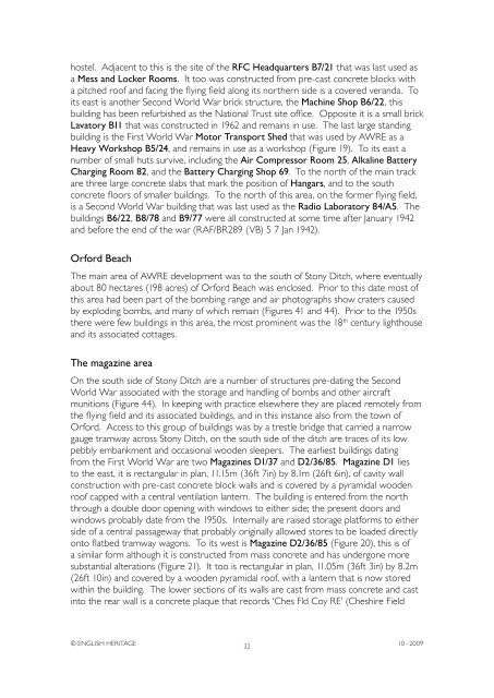
onto flatbed tramway wagons. To its west is Magazine D2/36/85 (Figure 20), this is of<br />
a similar form although it is constructed from mass concrete and has undergone more<br />
substantial alterations (Figure 21). It too is rectangular in plan, 11.05m (36ft 3in) by 8.2m<br />
(26ft 10in) and covered by a wooden pyramidal roof, with a lantern that is now stored<br />
within the building. The lower sections of its walls are cast from mass concrete and cast<br />
into the rear wall is a concrete plaque that records ‘Ches Fld Coy RE’ (Cheshire Field<br />
© ENGLISH HERITAGE<br />
32<br />
10 - 2009


