

Atomic Weapons Research Establishment. Orford ... - English Heritage
Atomic Weapons Research Establishment. Orford ... - English Heritage
Atomic Weapons Research Establishment. Orford ... - English Heritage

You also want an ePaper? Increase the reach of your titles
YUMPU automatically turns print PDFs into web optimized ePapers that Google loves.
of toeboards, separating an inner clean magazine area from the outer dirty area. The<br />
two bays differ slightly in size, the south bay measures 7.45m (24ft 6ins) by 4.55m (15ft),<br />
and the north bay measures 9.15m (30ft) by 7.45m (24ft 6in), both are 5.12m (16ft) high.<br />
Each was ventilated through a roof vent with a tall vertical stack projecting through the<br />
roof, and by a pair of vents leading into a rear air conditioning plant room, which was<br />
entered through a single door to the south.<br />
Final AWRE phases<br />
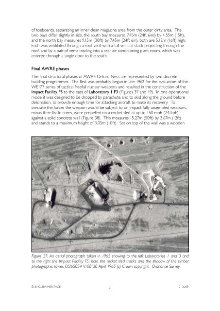
The final structural phases of AWRE <strong>Orford</strong> Ness are represented by two discrete<br />
building programmes. The first was probably begun in late 1962 for the evaluation of the<br />
WE177 series of tactical freefall nuclear weapons and resulted in the construction of the<br />
Impact Facility F5 to the east of Laboratory 1 F3 (Figures 37 and 49). In one operational<br />
mode it was designed to be dropped by parachute and to skid along the ground before<br />
detonation, to provide enough time for attacking aircraft to make its recovery. To<br />
simulate the forces the weapon would be subject to on impact fully assembled weapons,<br />
minus their fissile cores, were propelled on a rocket sled at up to 150 mph (241kph)<br />
against a solid concrete wall (Figure 38). This measures 15.27m (50ft) by 3.67m (12ft)<br />
and stands to a maximum height of 3.05m (10ft). Set on top of the wall was a wooden<br />
Figure 37: An aerial photograph taken in 1965 showing to the left Laboratories 1 and 3 and<br />
to the right the Impact Facility F5, note the rocket sled tracks and the shadow of the timber<br />
photographic tower. OS/65054 V108 30 April 1965 (c) Crown copyright. Ordnance Survey<br />
© ENGLISH HERITAGE<br />
53<br />
10 - 2009


